Epreuve originale réalisée vers 1680. Cundier Louis Auteur.Fines traces de plis dans l’encadrement.Classiques renforts au dos de la marge inférieure.Bon état.Format feuille : 51 x 41,5cm.Orignal antiq[...]
Original folding map mounted on linenRare and highly detailed folding map of London published by George Frederick Cruchley, titled Cruchley’s New Plan of London, in the edition “Improved to 1st Januar[...]
Plan of a small Estate located in Bordeaux, whose auction (...) is to take place on May 14, 1845. Watercolored plan, taken in 1821. Folds and tears, small paper losses on the edges, small soiling. 40.[...]
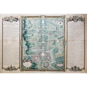
https://cartes-livres-anciens.com/produit/cartes-geographiques-anciennes-original-antique-maps/france/ile-de-france-78-versailles/plan-monumental-de-versailles-ville-et-chateau/Original plan from 1717[...]
Räth terrestrial globe. Varnished turned wooden base. Printed in Leipzig. Publisher Paul RÄTH Height: 47 cm Diameter 33 cm Made in GDR ex GDR Scale 1: 38 600 000 Year 1983 (March) Good general conditi[...]
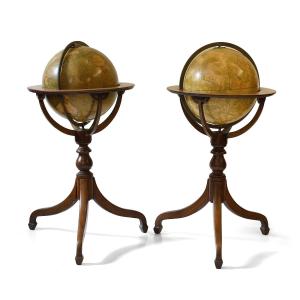
Smiths & Son, Celestial and Terrestrial Globes, London, 19th centuryTwo wooden globes covered with paper spindles bearing captions and engravings, one depicting the terrestrial globe and one the celes[...]
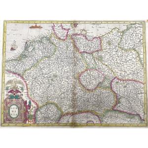
Epreuve originale réalisée vers 1780. Denis et Patour éditeur.Fines traces de plis dans l’encadrement.Beaux coloris anciens.Bon état.Format feuille : 68 x 46 cm.Original antique map of 1780.Grande car[...]
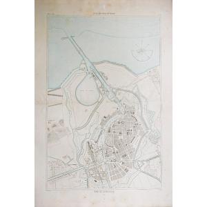
Epreuve originale réalisée en 1898. Labouche frères éditeurs.Première édition.Impression en couleurs.1 rousseur dans la rue de la Chaine.Très bon état.Format feuille : 59 x 48,5 cm.Format replié : 13,[...]
Giovanni Maria Cassini 1745 – 1824
Six antique engravings from the "Nuovo Atlante Geografico Universale delineato sulle ultime osservazioni", published in Rome from 1792 to 1801: – World Map – Spheri[...]
Epreuve originale réalisée vers 1630. Johannes Jansson cartographe.Fines rousseurs dans la marge supérieure loin de la carte.Très beaux coloris anciensTexte explicatif au verso en vieux français.Très [...]
Map of the French capital Paris and its environs published by cartographer Louis-Charles Desnos in 1787. Louis Charles Desnos (1725-1805) was the son of a cloth merchant from Pont-Sainte-Maxence and w[...]
Epreuve originale réalisée en 1556. Munster éditeur.Beaux coloris aquarelle, gravée sur bois.Texte explicatif en vieux français sous l’épreuve et au verso.Classique renfort au dos du pli central.Fine [...]
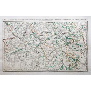
Carte ancienne gouvernement du DauphinéEpreuve originale réalisée vers 1710. De Witt cartographe.Limites colorées de l’époque.Très bon état.Format feuille : 62,5 x 53,5 cm.Format gravure : 60,5 x 50 c[...]
This color map is from the 18th century. It was framed under glass in the 1960s. It is in generally acceptable condition, but not perfect, with some foxing. Our photos allow you to appreciate the qual[...]
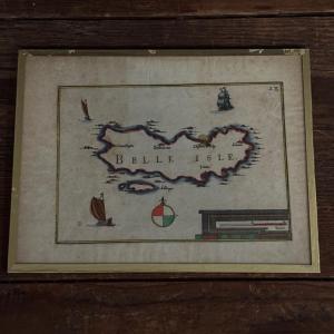
This color engraving is from the 17th century, it is authentic and old. It bears the inscription "Belle Isle" and the number 28 at the top right. It was framed under glass in the 1960s. You will notic[...]
Les élections de Tours, d’Amboise, de Loches, de Richelieu, de Chinon, de Bauge, de Montreuil Bellay et d’Angers, dans la généralité de Tours.Epreuve originale réalisée en 1711. Jaillot cartographe.Li[...]
Grand plan original réalisé en 1860.Entoilé d’époque et monté en 32 sections.Rousseurs claires éparses.Bon état.Format feuille : 111,5 x 94 cm.Format repliée : 24 x 14 cm.Original antique map of 1860.[...]
LUTECE conquered by the French from the Romans; or Second Map of the City of Paris original old engraving, colored with watercolor, old colors 1705 by M.L.C.D.L.M. (meaning : Monsieur Le Commissaire D[...]
Grande épreuve originale réalisée en 1908. Publiée par la Compagnie Scarborough.Carte recto verso gravée sur papier parcheminé.Très belle impression en couleurs.Emboitage d’époque.traces de plis d'ori[...]
Rare historical document: Handwritten letter signed in 1786 by José Moñino y Redondo, better known as the Count of Floridablanca, a prominent 18th-century Spanish political figure and Minister of Stat[...]
Epreuve originale réalisée en 1899. Lecocq graveur.Impression en couleurs.Très bon état.Format feuille : 39 x 29 cm.Original antique map of 1899.Edition de la fin du 19ème siècle agrémentée d’un carto[...]
Title of the engraving, MONSPESSULANUS, MONTPELLIER. Copper engraving colored in watercolor, this copy seems to be one of the oldest, from 1575. The work, initially published in Latin around 1572 unde[...]
Old map of the Duchy of Savoy, 17th century. Water stains, small foxing. 46 x 56 cm. Sent by Colissimo with signature. Careful packaging. Unless otherwise indicated, the objects published on Proantic [...]
Carte géographique ancienne de la Perse – Iran Grande épreuve originale en seconde édition de 1785 par Dezauche.Limites colorées de l’époque.Très bon état.Format feuille : 82 x 57,5 cm.Format gravure[...]
Epreuve originale réalisée en 1867. Chez J. Rothschild éditeur.Beaux coloris aquarelle.Très bon état.Format feuille : 61 x 42,5 cm.Format gravure : 47,5 x 32,5 cm.Original antique engraving of 1867.Pl[...]
Grande épreuve originale réalisée en 1873.Impression en couleurs.Rousseurs claires dans les marges.Bon état.Format feuille : 95,5 x 66,5 cm.Original antique chart of 1873.Rare collection illustrant le[...]
Epreuve originale réalisée en 1608 éditée par Ortelius, d’après un travail de Licimo Guijeto réalisé en 1579.Beaux coloris anciens.2 rousseurs claires dans les marges, et 3 renforts de papier au dos.T[...]
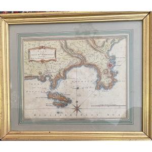
Map of the harbor of Brest and those of Bertheaume and Camaret, titled in a cartouche at the top left with the scale of the places, below, fleur-de-lis indicating the North. Original proof made around[...]
Mercator color map of the County Carlow region in southeastern Ireland, with decorative cartouche at bottom left. Map engraved by Gerard MERCATOR, probably from the French edition of the atlas publish[...]
Beautiful colored engraving of Guyenne, one of the largest provinces of France under the Ancien Régime. It included various regions and provinces such as Périgord, Agenais, Quercy, and Rouergue. Very [...]
Gerardum Mercatorem Cum Privilegio. Map engraved by Gérard MERCATOR from the French edition of the atlas published by HONDIUS.Gerardi Mercatoris - The Atlas or Cosmographic Meditations of the Fabricat[...]
This rare map of ancient Greece depicts the region at the time of Agamemnon, Helen of Troy, and Homer. The map expands to show western Turkey. Decorated with an elaborate title cartouche symbolizing t[...]
Geographical map BOHEMIA engraved by G MERCATOR between 1613 and 1616 (Czech Republic, Prague) map engraved by Gérard MERCATOR from the French edition of the atlas published by HONDIUS between 1613 an[...]
Original engraving paper from the time, framed, in excellent condition, size 53x42. . Decorative map of the Netherlands, published by Rossi in his Mercury geographical guide in all parts of the world [...]
Map of the Levant countries traveled by M Paul Lucas, drawn up on his memoirs and on some others by G De l'Isle of the Royal Academy – 1712 Paul Lucas (1664–1737) sculptor B. Ruyter Paul Lucas receive[...]
Large map of Gaul under the Romans produced in 1820 by Brué, Adrien-Hubert (1786-1832) to be used for reading the History of France before the establishment of the monarchy Desray bookseller publisher[...]
A significant historical episode of the city of Toulon, the 1707 siege took place in the context of England’s territorial expansion during the War of the Spanish Succession.Our map, has for legend : “[...]
Epreuve originale réalisée en 1771. Desnos géographe.Rousseurs claires dans les textes explicatifs.Bon état.Format feuille : 55,5 x 40 cm.Original antique map of 1771.Gouvernements d’Orléanois, de Tou[...]
RARE NAUTICAL CHART OF CANCALE TO THE POTERIEU ISLANDS - SAINT MALO BAY - POINTE SAINT CAST - HERQUY - SAINT BRIEUX - Ep. END OF THE 17TH CENTURY PART OF THE BRITTANY COAST - SAINT MALORARE BAY NAUTIC[...]
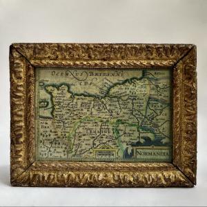
Map of Normandy (extending to Paris and Picardy in the East), in a very attractive little 18th-century carved and gilded wooden frame. Dimensions: height 12.8 cm - width 16.7 cm. Good overall conditio[...]
Watercolor map of Normandy by Tassin dating from 1634 with towns, a decoration of cartouches, a compass rose and a boat. Very beautiful original colors. Oak frame 28 cm x 23 cm.
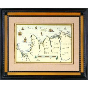
Watercolor map of Brittany by Tassin dating from 1634 with the towns, the islands of Groix, Belle Ile ... with decorations of cartouche, a compass rose and numerous boats. Very beautiful original colo[...]
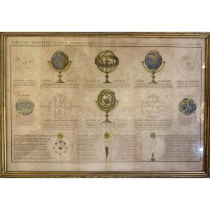
Beautiful hand-enhanced engraving dated 1838 by Charles François Delamarche (1740-1817) representing the different systems of the world by means of armillary spheres. Please note: The engraving is sli[...]
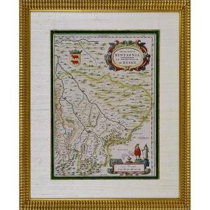
RARE MAP OF THE PRINCIPALITY OF BEARN (SOUTHWEST)Original intaglio engraving in period colors.It depicts the Principality of Béarn (Principatus Benearnia), a historical region located in the present-d[...]
TURGOT (Michel-Etienne) . Louis BRETEZ. Map of Paris, begun in 1734, drawn and engraved under the orders of Turgot, 1739. Old part showing the center of Paris: Place Royale, Pont Marie, Rue Saint-Anto[...]
Situé à la partie septentrionale de l’ile de CorseEpreuve originale réalisée en 1851. Gauttier Duparc lithographe.Coloris aquarelle.Très bon état.Format feuille : 29 x 21 cm.Original antique chart of [...]
Carte gravée en 1895. L.Smith graveur.Coloris aquarelle.Bon état.Format : 52,5 x 39,5 cm.Original antique map of 1895.Edition de la fin du 19ème siècle, impression en couleurs. Cartouche aquarellé ill[...]
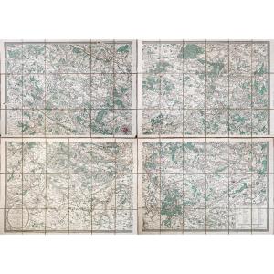
4 Plans entoilés d’époque montés en 18 sections.Coloris aquarelle.Emboitage avec traces de frottements, couvercle fendu.Très bon état.Format de chaque plan : 71 x 50,5 cm.Format assemblé : 145 x 105 c[...]
Pair of maps of Europe 18th century Cartographer R. Bonne "Orbis Vetus", The world in antiquity April 1781 Copper engraving Image 32 x 21 cm Full page: 37.5 x 26.5 cm Cartographer R. Bonne "General ma[...]
World map specially drawn and engraved based on the most recent documents. Large original proof made between 1897 and 1900. Color printing. Canvas-backed for perfect conservation. Very good condition.[...]
Epreuve originale réalisée en 1581. Abraham Ortelius éditeur.Texte explicatif en vieux français au verso.Beaux coloris aquarelle.Très bon état.Format feuille : 60,5 x 43,5 cm.Format gravure : 51,5 x 3[...]
Map of the Kingdom of Naples divided into all its provinces Paris 1703 Map from the very beginning of the 18th century made by Hubert Jaillot, (1632- November 3, 1712) French geographer and cartograph[...]
Carte originale réalisée en 1895. L. Smith graveur.Très bon état.Format feuille : 53 x 39,5 cm.Original antique map of 1895.Edition de la fin du 19ème siècle, impression en couleurs.s Vignettesaquarel[...]
Carte gravée en 1894.Belle impression en couleurs.Très bon état.Format feuille : 67 x 49 cm.Original antique chart of 1894.Rare collection illustrant les ports de France.Institution qui modèle le litt[...]
Proantic uses a cookie to analyze traffic and improve its service by using Google Analytics. Data sent to Google Analytics (frequency of visits to the site and pages visited) are anonymous. No other cookie tracks your activity, your personal data is not collected. Thank you for helping us to have better understanding how Proantic is used.


 Le Magazine de PROANTIC
 TRÉSORS Magazine
 Rivista Artiquariato