THIS OBJECT WAS SOLD
Old Map Of The History Of Palestine


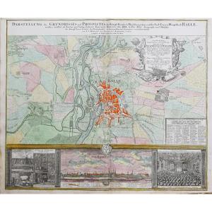
Carte originale réalisée en 1895. L. Smith graveur.
Très bon état.
Format feuille : 53 x 39,5 cm.
Original antique map of 1895.
Edition de la fin du 19ème siècle, impression en couleurs.s Vignettesaquarellées illustrant le temple de Salomon et d’Hérode.
Vous pouvez consulter l’ensemble des cartes, livres et gravures disponibles en cliquant sur le lien de notre site internet spécialisé en archives, livres et documents anciens géographiques : https://cartes-livres-anciens.com/categorie-produit/cartes-geographiques-anciennes-original-antique-maps/moyen-orient/israel-palestine-jordanie/
Règlement sécurisé par carte bancaire sur notre site internet en cliquant sur le lien ci-dessous :
https://cartes-livres-anciens.com/produit/cartes-geographiques-anciennes-original-antique-maps/moyen-orient/israel-palestine-jordanie/carte-ancienne-de-lhistoire-de-la-palestine/
Toutes nos cartes, livres et gravures sont accompagnées d’un certificat d’authenticité.
Original map made in 1895. L. Smith engraver. Very good condition. Sheet size: 53 x 39.5 cm. Original antique map of 1895. Edition from the end of the 19th century, printed in colors. Watercolored vignettes illustrating the temple of Solomon and Herod. You can consult all the maps, books and engravings available by clicking on the link to our website specializing in archives, books and old geographical documents: https://cartes-livres-anciens.com/categorie-produit/cartes-geographiques-anciennes-original-antique-maps/moyen-orient/israel-palestine-jordanie/ Secure payment by credit card on our website by clicking on the link below: https://cartes-livres-anciens.com/produit/cartes-geographiques-anciennes-original-antique-maps/moyen-orient/israel-palestine-jordan/carte-ancienne-de-lhistoire-de-la-palestine/ All our maps, books and engravings are accompanied by a certificate of authenticity.
Explore similar pieces and discover your ideal find:
Old Maps