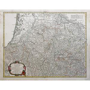
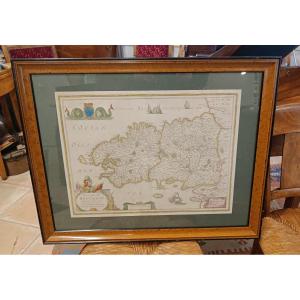
Old Map Of The English Channel - Brittany - Normandy
Artist: Visscher
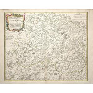
Epreuve originale réalisée vers 1690. Visscher cartographe.
Beaux coloris anciens.
Très bon état.
Format feuille : 64 x 52,5 cm.
Format gravure : 56,5 x 48 cm.
Original antique map around 1690.
Très belle carte du Canal de la Manche illustrant la partie nord de l’Angleterre, la Bretagne, la Normandie ainsi qu’une partie de la Touraine.
Vous pouvez consulter l’ensemble des cartes, livres et gravures disponibles sur votre région en cliquant sur le lien de notre site internet spécialisé en archives anciennes géographiques : https://cartes-livres-anciens.com/categorie-produit/cartes-geographiques-anciennes-original-antique-maps/france/bretagne/
Règlement sécurisé par carte bancaire sur notre site internet en cliquant sur le lien ci-dessous : https://cartes-livres-anciens.com/produit/cartes-geographiques-anciennes-original-antique-maps/europe/angleterre-irlande-ecosse/carte-ancienne-du-canal-de-la-manche/
Toutes nos cartes et gravures sont accompagnées d’un certificat d’authenticité.
VISSCHER
Pendant près d’un siècle, les membres de la famille Visscher étaient d’importants marchands d’art et éditeurs de cartes à Amsterdam. Le fondateur de l’entreprise, C. J. Visscher, avait des locaux proches de ceux de Pieter van den Keere et de Jodocus Hondius, dont il était peut-être l’élève.
À partir de 1620 environ, il conçut un certain nombre de cartes individuelles, dont l’une des îles Britanniques, mais son premier atlas consistait en des cartes imprimées à partir de planches achetées à van den Keere et émises telles quelles avec quelques ajouts, dont des scènes historiques de batailles. Certaines cartes portent la forme latinisée du nom de famille : Piscator.
Après la mort de Visscher, son fils et son petit-fils, tous deux du même nom, ont publié un nombre considérable d’atlas, constamment révisés et mis à jour, mais la plupart d’entre eux manquant d’index et de contenu varié. La veuve de Nicholaes Visscher II a poursuivi l’affaire jusqu’à ce qu’elle soit finalement passée aux mains de Pieter Schenk.
Original proof made around 1690. Visscher cartographer. Beautiful old colors. Very good condition. Sheet size: 64 x 52.5 cm. Engraving size: 56.5 x 48 cm. Original antique map around 1690. Very beautiful map of the English Channel illustrating the northern part of England, Brittany, Normandy and part of Touraine. You can consult all the maps, books and engravings available in your region by clicking on the link to our website specializing in old geographical archives: https://cartes-livres-anciens.com/categorie-produit/cartes-geographiques-anciennes-original-antique-maps/france/bretagne/ Secure payment by credit card on our website by clicking on the link below: https://cartes-livres-anciens.com/produit/cartes-geographiques-anciennes-original-antique-maps/europe/angleterre-irlande-cosse/carte-ancienne-du-canal-de-la-manche/ All our maps and engravings are accompanied by a certificate of authenticity.VISSCHERFor nearly a century, members of the Visscher family were prominent art dealers and map publishers in Amsterdam. The firm's founder, C.J. Visscher, had premises near those of Pieter van den Keere and Jodocus Hondius, of whom he may have been a pupil. From about 1620, he designed a number of individual maps, including one of the British Isles, but his first atlas consisted of maps printed from plates purchased from van den Keere and issued as is with a few additions, including historical battle scenes. Some maps bear the Latinized form of the family name: Piscator. After Visscher's death, his son and grandson, both of the same name, published a considerable number of atlases, which were constantly revised and updated, but most of them lacked indexes and varied content. Nicholas Visscher II's widow continued the business until it finally passed into the hands of Pieter Schenk.
470 €
Period: 17th century
Style: Other Style
Condition: Excellent condition
Material: Paper
Reference (ID): 1549040
Availability: In stock
Print