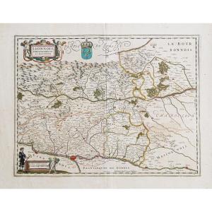
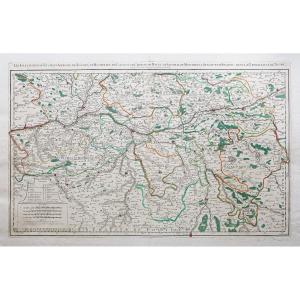


Old Map Of The Pays De La Loire
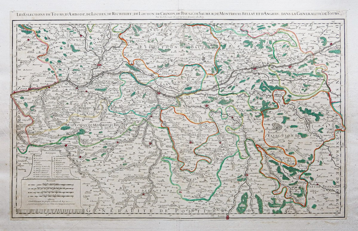
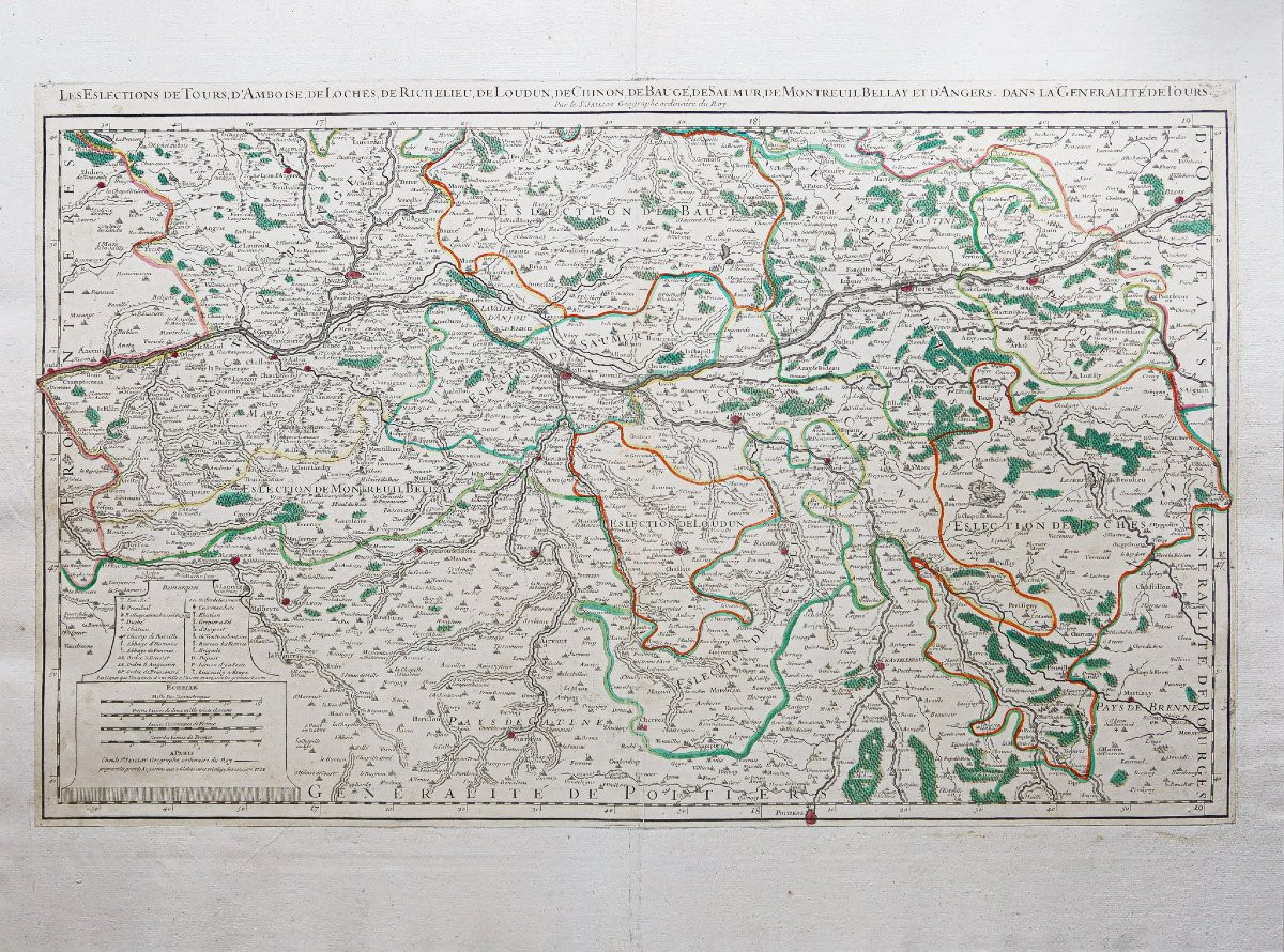
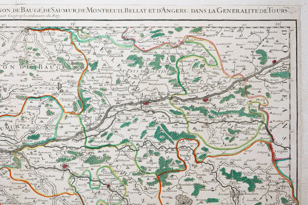
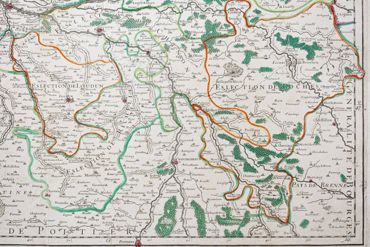
Les élections de Tours, d’Amboise, de Loches, de Richelieu, de Chinon, de Bauge, de Montreuil Bellay et d’Angers, dans la généralité de Tours.
Epreuve originale réalisée en 1711. Jaillot cartographe.
Limites colorées de l’époque.
Réemmargée anciennement.
Bon état.
Format feuille : 80 x 59,5 cm.
Format gravure : 74 x 46,5 cm.
Original antique map of 1711.
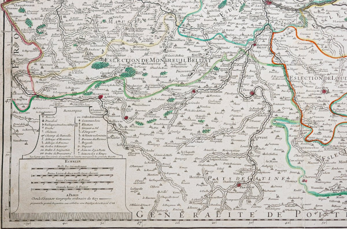
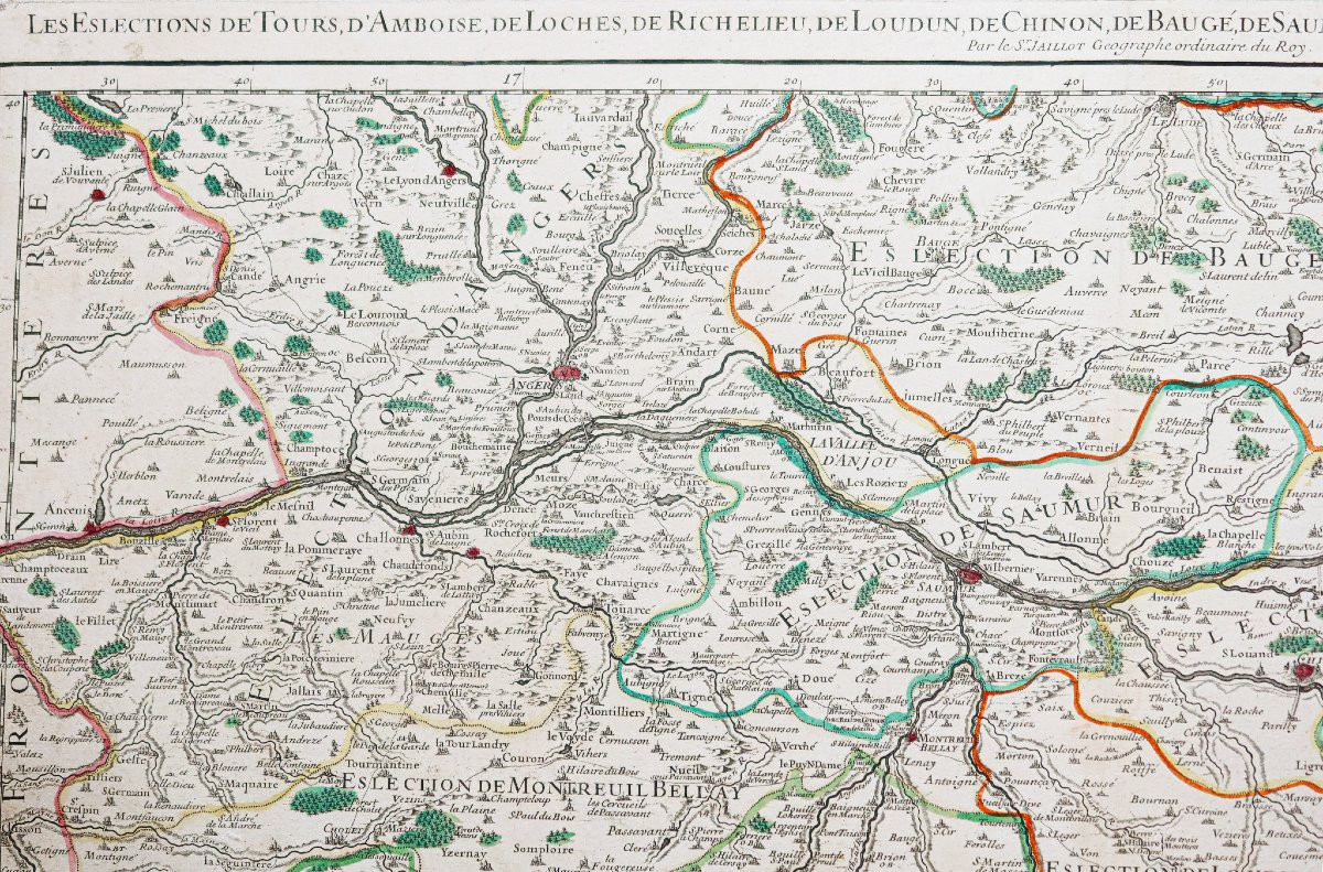
Carte de la région Centre Val de Loire de Blois à Oudon et Le Jude à Poitiers.
Encart avec échelle des lieux et repères situant les principaux monuments, Châteaux, abbayes de la région.
Vous pouvez consulter l’ensemble des cartes, livres et gravures disponibles sur votre région en cliquant sur le lien de notre site internet spécialisé en archives anciennes géographiques : https://cartes-livres-anciens.com/categorie-produit/cartes-geographiques-anciennes-original-antique-maps/france/centre-val-de-loire/
Règlement sécurisé par carte bancaire sur notre site internet en cliquant sur le lien ci-dessous : https://cartes-livres-anciens.com/produit/cartes-geographiques-anciennes-original-antique-maps/france/centre-val-de-loire/carte-ancienne-des-pays-de-la-loire/
Toutes nos cartes et gravures sont accompagnées d’un certificat d’authenticité.
Alexis-Hubert Jaillot (1632-1712) est un ingénieur géographe et cartographe français, imprimeur à Paris, de la fin du XVIIe siècle et du début du XVIIIe siècle, au service du roi Louis XIV.
« Les plus grandes cartes du 17ème siècle »
Il publie de nombreux travaux de géographes contemporains ainsi que ses propres œuvres.
« L’Atlas François », Jaillot, 1692-1695, compilation des cartes de Nicolas Sanson (cartographe), Édité à Paris et à Amsterdam chez R. et J. Ottens.
Son travail sera continué par son fils, Bernard Jean Hyacinthe Jaillot (1673-1739), son petit-fils, Bernard Antoine Jaillot, ainsi que le beau-frère de celui-ci, Jean Baptiste-Michel Renou de Chauvigné dit Jaillot (1710-1780).
The elections of Tours, Amboise, Loches, Richelieu, Chinon, Bauge, Montreuil Bellay and Angers, in the generality of Tours. Original proof made in 1711. Jaillot cartographer. Coloured limits of the time. Re-margined formerly. Good condition. Sheet size: 80 x 59.5 cm. Engraving size: 74 x 46.5 cm. Original antique map of 1711. Map of the Centre Val de Loire region from Blois to Oudon and Le Jude to Poitiers. Insert with scale of places and markers locating the main monuments, castles, abbeys of the region. You can consult all the maps, books and engravings available on your region by clicking on the link of our website specialized in old geographical archives: https://cartes-livres-anciens.com/categorie-produit/cartes-geographiques-anciennes-original-antique-maps/france/centre-val-de-loire/ Secure payment by credit card on our website by clicking on the link below: https://cartes-livres-anciens.com/produit/cartes-geographiques-anciennes-original-antique-maps/france/centre-val-de-loire/carte-ancienne-des-pays-de-la-loire/ All our maps and engravings are accompanied by a certificate of authenticity. Alexis-Hubert Jaillot (1632-1712) was a French geographer and cartographer, printer in Paris, from the end of the 17th century and the beginning of the 18th century, in the service of King Louis XIV. "The greatest maps of the 17th century" He published many works by contemporary geographers as well as his own works. "L'Atlas François", Jaillot, 1692-1695, compilation of maps by Nicolas Sanson (cartographer), published in Paris and Amsterdam by R. and J. Ottens. His work was continued by his son, Bernard Jean Hyacinthe Jaillot (1673-1739), his grandson, Bernard Antoine Jaillot, as well as his brother-in-law, Jean Baptiste-Michel Renou de Chauvigné known as Jaillot (1710-1780).
Epreuve originale réalisée en 1711. Jaillot cartographe.
Limites colorées de l’époque.
Réemmargée anciennement.
Bon état.
Format feuille : 80 x 59,5 cm.
Format gravure : 74 x 46,5 cm.
Original antique map of 1711.
Carte de la région Centre Val de Loire de Blois à Oudon et Le Jude à Poitiers.
Encart avec échelle des lieux et repères situant les principaux monuments, Châteaux, abbayes de la région.
Vous pouvez consulter l’ensemble des cartes, livres et gravures disponibles sur votre région en cliquant sur le lien de notre site internet spécialisé en archives anciennes géographiques : https://cartes-livres-anciens.com/categorie-produit/cartes-geographiques-anciennes-original-antique-maps/france/centre-val-de-loire/
Règlement sécurisé par carte bancaire sur notre site internet en cliquant sur le lien ci-dessous : https://cartes-livres-anciens.com/produit/cartes-geographiques-anciennes-original-antique-maps/france/centre-val-de-loire/carte-ancienne-des-pays-de-la-loire/
Toutes nos cartes et gravures sont accompagnées d’un certificat d’authenticité.
Alexis-Hubert Jaillot (1632-1712) est un ingénieur géographe et cartographe français, imprimeur à Paris, de la fin du XVIIe siècle et du début du XVIIIe siècle, au service du roi Louis XIV.
« Les plus grandes cartes du 17ème siècle »
Il publie de nombreux travaux de géographes contemporains ainsi que ses propres œuvres.
« L’Atlas François », Jaillot, 1692-1695, compilation des cartes de Nicolas Sanson (cartographe), Édité à Paris et à Amsterdam chez R. et J. Ottens.
Son travail sera continué par son fils, Bernard Jean Hyacinthe Jaillot (1673-1739), son petit-fils, Bernard Antoine Jaillot, ainsi que le beau-frère de celui-ci, Jean Baptiste-Michel Renou de Chauvigné dit Jaillot (1710-1780).
The elections of Tours, Amboise, Loches, Richelieu, Chinon, Bauge, Montreuil Bellay and Angers, in the generality of Tours. Original proof made in 1711. Jaillot cartographer. Coloured limits of the time. Re-margined formerly. Good condition. Sheet size: 80 x 59.5 cm. Engraving size: 74 x 46.5 cm. Original antique map of 1711. Map of the Centre Val de Loire region from Blois to Oudon and Le Jude to Poitiers. Insert with scale of places and markers locating the main monuments, castles, abbeys of the region. You can consult all the maps, books and engravings available on your region by clicking on the link of our website specialized in old geographical archives: https://cartes-livres-anciens.com/categorie-produit/cartes-geographiques-anciennes-original-antique-maps/france/centre-val-de-loire/ Secure payment by credit card on our website by clicking on the link below: https://cartes-livres-anciens.com/produit/cartes-geographiques-anciennes-original-antique-maps/france/centre-val-de-loire/carte-ancienne-des-pays-de-la-loire/ All our maps and engravings are accompanied by a certificate of authenticity. Alexis-Hubert Jaillot (1632-1712) was a French geographer and cartographer, printer in Paris, from the end of the 17th century and the beginning of the 18th century, in the service of King Louis XIV. "The greatest maps of the 17th century" He published many works by contemporary geographers as well as his own works. "L'Atlas François", Jaillot, 1692-1695, compilation of maps by Nicolas Sanson (cartographer), published in Paris and Amsterdam by R. and J. Ottens. His work was continued by his son, Bernard Jean Hyacinthe Jaillot (1673-1739), his grandson, Bernard Antoine Jaillot, as well as his brother-in-law, Jean Baptiste-Michel Renou de Chauvigné known as Jaillot (1710-1780).
290 €
Period: 18th century
Style: Other Style
Condition: Excellent condition
Material: Paper
Reference (ID): 1571577
Availability: In stock
Print