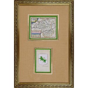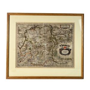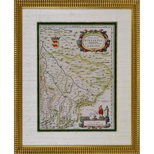


Engraving - Map Of The Principality Of Bearn (south West) By J. Blaeu - Ep. 17th Century (circa 1640)
Artist: J Blaeu - Cartographe
RARE MAP OF THE PRINCIPALITY OF BEARN (SOUTHWEST)Original intaglio engraving in period colors.It depicts the Principality of Béarn (Principatus Benearnia), a historical region located in the present-day Pyrénées-Atlantiques department in southwest France.By Joan BLAEU (1596–1673), one of the most famous Dutch cartographers of the 17th century. "PRINCIPATVS BENEARNIA. The Principality of Béarn" is inscribed in a cartouche sumptuously decorated with polychrome scrolls and foliage, typical of the Baroque style.At the top left are the coat of arms of Béarn—two red cows on a gold background, crowned—the ancestral symbol of this Pyrenean region.The map is oriented with north at the top, as indicated by the words Septentrio (north) at the top and Meridies (south) at the bottom. At the bottom right, a decorative cartouche presents a graphic scale entitled Lieues Bearnoises, surmounted by an antique incense burner and framed by two figures dressed in traditional Béarnese costumes, testifying to the ethnographic interest specific to the period. The Adour River structures the landscape on the left side of the map. The Pyrenean relief is rendered by shaded and stylized mountain motifs. The main localities — such as Pau, Orthez, Oloron, Navarrenx, or Sauveterre — are indicated, often accompanied by schematic illustrations of buildings or fortifications. The neighboring regions are also designated, notably Gascony, Soule, Bigorre, Labédant, as well as the Navarre Frontier. Dimension(s): Height 56 cm – Length 46 cm - Width Baguette: 3 cm,Condition(s): PERFECT CONDITION,Era: 1st HALF 17th century (Circa 1640),Framing: CURRENT - Composed of a bronze green wild silk net, an aged gold bevel, a marie-louise in ecru wild silk, all framed by a wooden baguette in water gilding.PAYMENT and TRANSPORTPAYMENTS ACCEPTED BANK TRANSFER / PAYPAL / BANK TRANSFER / CB online or by CHECK (Possibility of payment in installments).PARCELS WILL BE POSTED WITHIN 4 DAYS. GROUPED SHIPPING POSSIBLE IN CASE OF PURCHASE OF SEVERAL ITEMS.
580 €
Period: 17th century
Style: Louis 14th, Regency
Condition: Perfect condition
Material: Paper
Length: 46 cm
Height: 56 cm
Reference (ID): 1552297
Availability: In stock
Print