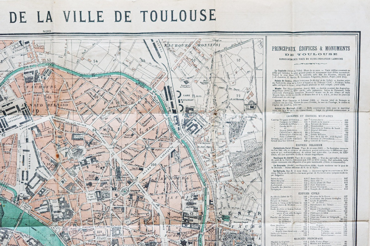


Old Map Of The City Of Toulouse
Première édition.
Impression en couleurs.
1 rousseur dans la rue de la Chaine.
Très bon état.
Format feuille : 59 x 48,5 cm.
Format replié : 13,5 x 9 cm.
Original antique map of 1898.
Plan détaillé de la ville de Toulouse. Encart avec description des principaux monuments et édifices, marchés, transports hôtels…
Vous pouvez consulter l’ensemble des cartes et gravures disponibles sur votre région en cliquant sur le lien de notre site internet spécialisé en archives anciennes géographiques :
https://cartes-livres-anciens.com/categorie-produit/cartes-geographiques-anciennes-original-antique-maps/france/midi-pyrenees/
Règlement sécurisé par carte bancaire sur notre site internet en cliquant sur le lien :
https://cartes-livres-anciens.com/produit/cartes-geographiques-anciennes-original-antique-maps/france/midi-pyrenees/plan-ancien-de-la-ville-de-toulouse/
Toutes nos cartes et gravures sont accompagnées d’un certificat d’authenticité.
Original proof made in 1898. Labouche frères éditeurs. First edition. Color printing. 1 foxing in the rue de la Chaine. Very good condition. Sheet size: 59 x 48.5 cm. Folded size: 13.5 x 9 cm. Original antique map of 1898. Detailed plan of the city of Toulouse. Insert with description of the main monuments and buildings, markets, transport, hotels...You can consult all the maps and engravings available in your region by clicking on the link to our website specializing in old geographical archives: https://cartes-livres-anciens.com/categorie-produit/cartes-geographiques-anciennes-original-antique-maps/france/midi-pyrenees/Secure payment by credit card on our website by clicking on the link: https://cartes-livres-anciens.com/produit/cartes-geographiques-anciennes-original-antique-maps/france/midi-pyrenees/plan-ancien-de-la-ville-de-toulouse/All our maps and engravings are accompanied by a certificate of authenticity.
Period: 19th century
Style: Other Style
Condition: Excellent condition
Material: Paper
Reference (ID): 1580215
Availability: In stock