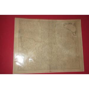
Antique Wall Map Of Italy – Corsica
Artist: Desnos
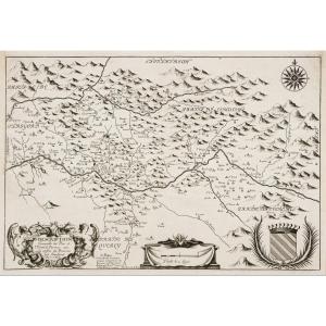
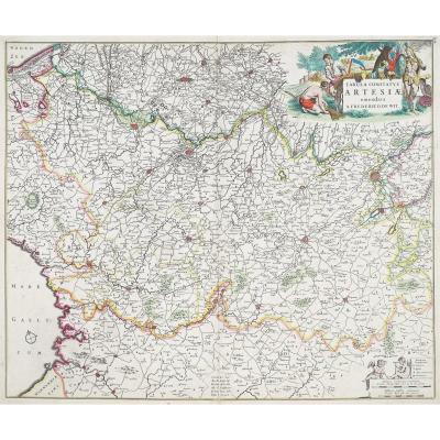
Carte d’Italie, assujettie aux observations astronomiques et aux itinéraires comprenant toutes les grandes routes qui traversent les différents états de cette région, avec les distances par postes.
Grande épreuve originale gravée en 1766. Desnos et Brion géographes.
Beaux coloris anciens.
Très bon état général.
Format assemblée : 94 (largeur) x 91,5 cm (hauteur).
Format de chaque feuille : 53 x 39,5 cm.
Carte gravée en 6 feuillets. Possibilité de montage sur demande.
Cartouche de titre décoratif et encart avec remarque explicative ; les chiffres à côté des routes expriment le nombre de postes d’un lieu à un autre. Echelle des lieux.
Vous pouvez consulter l’ensemble des cartes, livres et gravures disponibles sur votre région en cliquant sur le lien de notre site internet spécialisé en archives anciennes géographiques : https://cartes-livres-anciens.com/categorie-produit/cartes-geographiques-anciennes-original-antique-maps/europe/italie/
Règlement sécurisé par carte bancaire sur notre site internet en cliquant sur le lien ci-dessous : https://cartes-livres-anciens.com/produit/cartes-geographiques-anciennes-original-antique-maps/europe/italie/carte-murale-ancienne-de-litalie-corse/
Toutes nos cartes et gravures sont accompagnées d’un certificat d’authenticité.
Desnos a été un fabricant important d’instruments de cartographie et de globes. Il occupa auprès du roi de Danemark, Christian VII, le poste convoité de royal globe maker. Il recevait pour cela une allocation annuelle de 500 livres. En retour il envoyait chaque année au roi, des cartes, des livres et des atlas. Il fut libraire et éditeur et produit une collection de cartes importante. Il fut souvent associé aux géographes Zannoni et Louis brion de la Tour (1756-1823).
Sa grande production de cartes publiées lui a valu parfois, parmi ses détracteurs jaloux de sa notoriété, une mauvaise réputation parmi les autres cartographes, qui l’ont considéré sans scrupules et sans discernement de ce qui devait être publiable ou non.
Map of Italy, subject to astronomical observations and itineraries including all the major roads that cross the different states of this region, with the distances by posts. Large original proof engraved in 1766. Desnos and Brion geographers. Beautiful old colors. Very good general condition. Assembled format: 94 (width) x 91.5 cm (height). Format of each sheet: 53 x 39.5 cm. Map engraved in 6 sheets. Possibility of mounting on request. Decorative title cartridge and insert with explanatory note; the numbers next to the roads express the number of posts from one place to another. Scale of places. You can consult all the maps, books and engravings available on your region by clicking on the link of our website specialized in old geographical archives: https://cartes-livres-anciens.com/categorie-produit/cartes-geographiques-anciennes-original-antique-maps/europe/italie/ Secure payment by credit card on our website by clicking on the link below: https://cartes-livres-anciens.com/produit/cartes-geographiques-anciennes-original-antique-maps/europe/italie/carte-murale-ancienne-de-litalie-corse/ All our maps and engravings are accompanied by a certificate of authenticity. Desnos was an important manufacturer of cartographic instruments and globes. He held the coveted position of royal globe maker for the King of Denmark, Christian VII. He received an annual allowance of 500 pounds for this. In return, he sent the king maps, books, and atlases every year. He was a bookseller and publisher, producing a large collection of maps. He was often associated with the geographers Zannoni and Louis Brion de la Tour (1756–1823). His large output of published maps sometimes earned him a bad reputation among his detractors, jealous of his fame, among other cartographers, who considered him unscrupulous and without discernment about what should be publishable or not.
600 €
Period: 18th century
Style: Other Style
Condition: Excellent condition
Material: Paper
Reference (ID): 1597863
Availability: In stock
Print