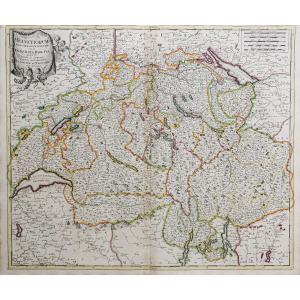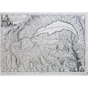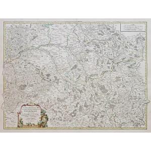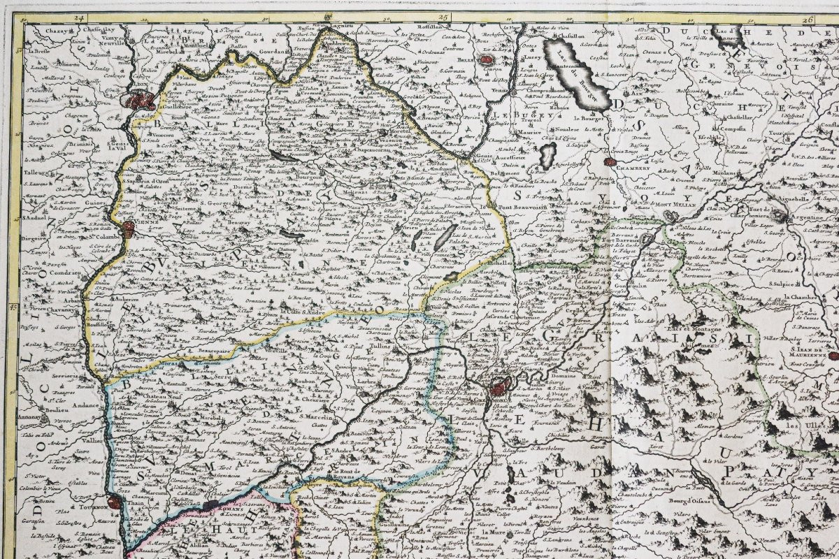
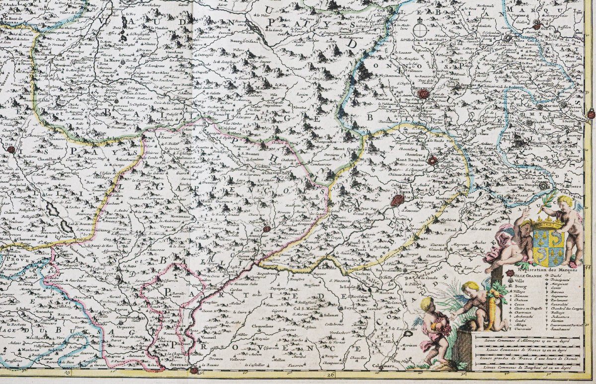


Old Map Of The Dauphiné Government
Carte ancienne gouvernement du Dauphiné
Epreuve originale réalisée vers 1710. De Witt cartographe.
Limites colorées de l’époque.
Très bon état.
Format feuille : 62,5 x 53,5 cm.
Format gravure : 60,5 x 50 cm.
Original antique map of 1710.
Le gouvernement général du Dauphiné divisé en haut et bas … avec privilège de nos très puissants Seigneurs.
Cartouche de titre surmonté de 2 angelots, explications des marques, échelle des lieux.
Vous pouvez consulter l’ensemble des cartes et gravures disponibles sur votre région en cliquant sur le lien de notre site internet spécialisé en archives anciennes géographiques : https://cartes-livres-anciens.com/categorie-produit/cartes-geographiques-anciennes-original-antique-maps/france/rhone-alpes/
Règlement sécurisé par carte bancaire sur notre site internet en cliquant sur le lien : https://cartes-livres-anciens.com/produit/cartes-geographiques-anciennes-original-antique-maps/france/rhone-alpes/carte-ancienne-gouvernement-du-dauphine/
Toutes nos cartes et gravures sont accompagnées d’un certificat d’authenticité.
De Witt fut l’un des graveurs de cartes et des éditeurs les plus en vue à Amsterdam dans la période qui suivit le déclin des établissements Blaeu et Jansson, auprès desquels il acquit de nombreuses plaques de cuivre lors de leur dispersion aux enchères. Ses travaux couvrent la plupart des aspects de la cartographie : cartes marines, atlas mondiaux, atlas des Pays-Bas, « livres de ville » couvrant les plans de villes des Pays-Bas et d’Europe, et cartes murales. Son travail, qui se distingue par la beauté de la gravure et de la couleur, a été très populaire et les éditions ont été publiées de nombreuses années après sa mort par Pieter Mortier et Covens and Mortier.
Old map of the government of Dauphiné. Original proof made around 1710. De Witt cartographer. Coloured boundaries of the time. Very good condition. Sheet size: 62.5 x 53.5 cm. Engraving size: 60.5 x 50 cm. Original antique map of 1710. The general government of Dauphiné divided into upper and lower … with privilege of our very powerful Lords. Title cartouche surmounted by 2 cherubs, explanations of the marks, scale of the places. You can consult all the maps and engravings available on your region by clicking on the link of our website specializing in old geographical archives: https://cartes-livres-anciens.com/categorie-produit/cartes-geographiques-anciennes-original-antique-maps/france/rhone-alpes/ Secure payment by credit card on our website by clicking on the link: https://cartes-livres-anciens.com/produit/cartes-geographiques-anciennes-original-antique-maps/france/rhone-alpes/carte-ancienne-gouvernement-du-dauphine/ All our maps and engravings are accompanied by a certificate of authenticity. De Witt was one of the most prominent map engravers and publishers in Amsterdam in the period following the decline of the Blaeu and Jansson firms, from whom he acquired many copper plates when they were dispersed at auction. His works cover most aspects of cartography: nautical charts, world atlases, atlases of the Netherlands, "city books" covering city plans of the Netherlands and Europe, and wall maps. His work, distinguished by the beauty of the engraving and color, was very popular and editions were published many years after his death by Pieter Mortier and Covens and Mortier.
325 €
Period: 18th century
Style: Other Style
Condition: Excellent condition
Material: Paper
Reference (ID): 1574604
Availability: In stock
Print