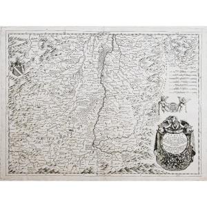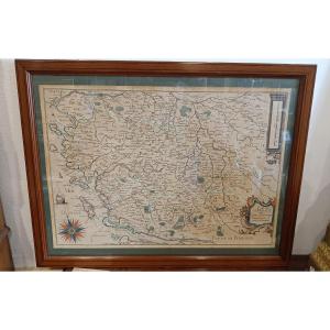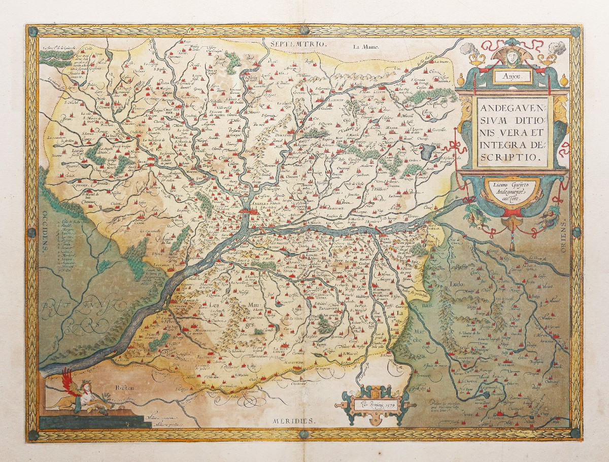
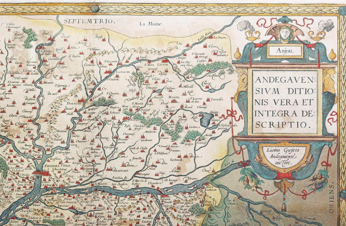
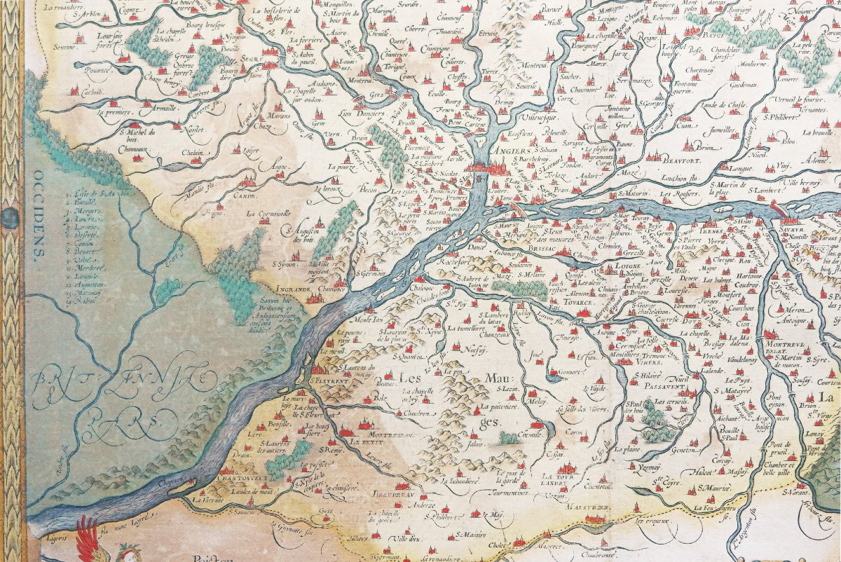


Old Geographical Map Of Anjou
Beaux coloris anciens.
2 rousseurs claires dans les marges, et 3 renforts de papier au dos.
Texte explicatif en italien au verso.
Très bon état.
Format feuille : 55 x 42 cm.
Format gravure : 47,5 x 35,5 cm.
Original antique map of 1608.
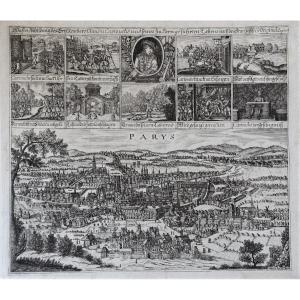
Carte publiée pour la première fois à Paris en 1573 par Lezin Guyet et dédié au Duc d’Anjou.
Vous pouvez consulter l’ensemble des cartes et gravures disponibles sur votre région en cliquant sur le lien de notre site internet spécialisé en archives anciennes géographiques : https://cartes-livres-anciens.com/categorie-produit/cartes-geographiques-anciennes-original-antique-maps/france/pays-de-la-loire/
Règlement sécurisé par carte bancaire sur notre site internet en cliquant sur le lien : https://cartes-livres-anciens.com/produit/cartes-geographiques-anciennes-original-antique-maps/france/pays-de-la-loire/carte-geographique-ancienne-de-lanjou-4/
Toutes nos cartes et gravures sont accompagnées d’un certificat d’authenticité.
Abraham Ortel, mieux connu sous le nom d’Ortelius, est né à Anvers et, après avoir étudié le grec, le latin et les mathématiques, s’y est établi avec sa sœur, en tant que libraire et « peintre de cartes ». Voyageant beaucoup, particulièrement aux grandes foires du livre, son entreprise prospéra et il noua des contacts avec des lettrés dans de nombreux pays.
Un tournant dans sa carrière est atteint en 1564 avec la publication d’une carte du monde en huit feuilles dont un seul exemplaire est connu : d’autres cartes individuelles suivront, puis, à la suggestion d’un ami, il rassemble une collection de cartes qu’il fit graver dans une taille uniforme, formant ainsi un ensemble de cartes qui fut publié pour la première fois en 1570 sous le nom de Theatrum Orbis Terrarum (Atlas du monde entier).
Bien que Lafreri et d’autres cartographes italiens aient publié des collections de cartes « modernes » sous forme de livre au cours des années précédentes, le Theatrum a été la première collection systématique de cartes de taille uniforme et peut donc être appelé le « premier atlas », bien que ce terme n’ait été utilisé vingt ans plus tard par Mercator.
Le Theatrum, avec la plupart de ses cartes élégamment gravées par Frans Hogenberg, connaît un succès immédiat et apparaît dans de nombreuses éditions dans différentes langues. La dernière édition de cartes parut en 1612.
Contrairement à bon nombre de ses contemporains, Ortelius nota ses sources d’informations. Dans la première édition, quatre-vingt-sept cartographes étaient remerciés.
Outre les cartes modernes de son atlas principal, Ortelius a lui-même compilé une série de cartes historiques connues sous le nom de Parergon Theatri, qui sont apparues à partir de 1579, parfois sous forme de publication distincte et parfois incorporées au Theatrum.
Original proof made in 1608 published by Ortelius, after a work by Licimo Guijeto made in 1579. Beautiful old colors. 2 light foxing in the margins, and 3 paper reinforcements on the spine. Explanatory text in Italian on the back. Very good condition. Sheet size: 55 x 42 cm. Engraving size: 47.5 x 35.5 cm. Original antique map of 1608. Map published for the first time in Paris in 1573 by Lezin Guyet and dedicated to the Duke of Anjou. You can consult all the maps and engravings available on your region by clicking on the link of our website specialized in old geographical archives: https://cartes-livres-anciens.com/categorie-produit/cartes-geographiques-anciennes-original-antique-maps/france/pays-de-la-loire/ Secure payment by credit card on our website by clicking on the link: https://cartes-livres-anciens.com/produit/cartes-geographiques-anciennes-original-antique-maps/france/pays-de-la-loire/carte-geographique-ancienne-de-lanjou-4/ All our maps and engravings are accompanied by a certificate of authenticity. Abraham Ortel, better known as Ortelius, was born in Antwerp and, after studying Greek, Latin and mathematics, settled there with his sister, as a bookseller and “map painter”. Traveling extensively, particularly to the great book fairs, his business prospered and he made contacts with scholars in many countries. A turning point in his career was reached in 1564 with the publication of a world map in eight sheets of which only one copy is known: other individual maps followed, and then, at the suggestion of a friend, he assembled a collection of maps which he had engraved in a uniform size, thus forming a set of maps which was first published in 1570 as the Theatrum Orbis Terrarum (Atlas of the Whole World). Although Lafreri and other Italian cartographers had published collections of 'modern' maps in book form in earlier years, the Theatrum was the first systematic collection of maps of a uniform size and can therefore be called the 'first atlas', although this term was not used until twenty years later by Mercator. The Theatrum, with most of its maps elegantly engraved by Frans Hogenberg, was a success immediate and appears in numerous editions in different languages. The last edition of maps appeared in 1612. Unlike many of his contemporaries, Ortelius noted his sources of information. In the first edition, eighty-seven cartographers were acknowledged. In addition to the modern maps in his main atlas, Ortelius himself compiled a series of historical maps known as the Parergon Theatri, which appeared from 1579 onwards, sometimes as a separate publication and sometimes incorporated into the Theatrum.
Period: 16th century
Style: Other Style
Condition: Excellent condition
Material: Paper
Reference (ID): 1562790
Availability: In stock