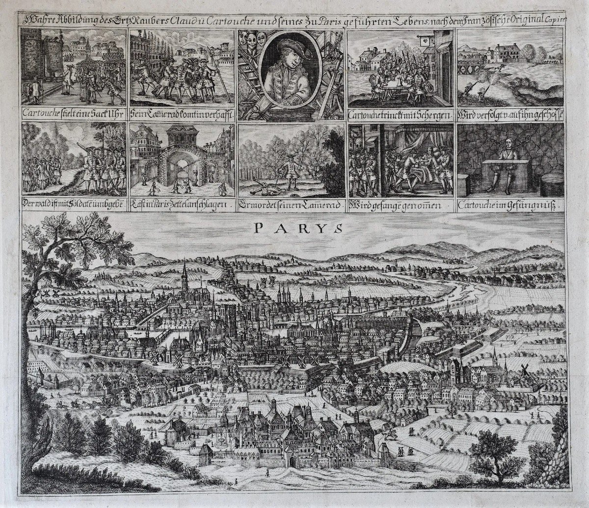
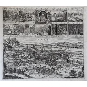
Map Of Paris And The History Of Cartouche
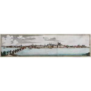
“Mahre Abbildung des Srtz Raubers Claudù Cartouche undfeines du Paris geführten Leben”. "The true illustrated story of the great brigand Cartouche and his life in Paris". Original plan engraved in 1722. Beautiful impression. Sheet size: 31 x 36 cm. Original antique map of 1722. Plan showing the panorama of Paris from Merian from the middle of the 17th century in the lower part. 10 vignettes illustrate on the upper part the exploits of Cartouche “The French Robin des Bois”. Rare plan not referenced in the work of Paris plans by Jean Boutier. You can consult all the maps, books and engravings available in your region by clicking on the link of our website specializing in ancient geographical archives: https://cartes-livres-anciens.com/categorie-produit/cartes-geographiques -anciens-original-antique-maps/france/paris-plans-maps/ Secure payment by credit card on our website by clicking on the link below: https://cartes-livres-anciens.com/produit/cartes -geographiques-anciennes-original-antique-maps/france/paris-plans-maps/plan-de-paris-et-lhistoire-de-cartouche/ All our maps and engravings are accompanied by a certificate of authenticity.
« Mahre Abbildung des Srtz Raubers Claudù Cartouche undfeines du Paris geführten Leben ».
« La véritable histoire illustrée du grand brigand Cartouche et de sa vie menée à Paris ».
Plan original gravé en 1722.
Belle impression.
Format feuille : 31 x 36 cm.
Original antique map of 1722.
Plan reprenant le panorama de Paris de Merian du milieu du 17ème siècle dans la partie inférieure.
10 vignettes illustrent sur la partie supérieure les exploits de Cartouche
» Le Robin des Bois français « .
Rare plan non référencé dans l’ouvrage des plans de Paris de Jean Boutier.
Vous pouvez consulter l’ensemble des cartes, livres et gravures disponibles sur votre région en cliquant sur le lien de notre site internet spécialisé en archives anciennes géographiques :
https://cartes-livres-anciens.com/categorie-produit/cartes-geographiques-anciennes-original-antique-maps/france/paris-plans-maps/
Règlement sécurisé par carte bancaire sur notre site internet en cliquant sur le lien ci-dessous :
https://cartes-livres-anciens.com/produit/cartes-geographiques-anciennes-original-antique-maps/france/paris-plans-maps/plan-de-paris-et-lhistoire-de-cartouche/
Toutes nos cartes et gravures sont accompagnées d’un certificat d’authenticité.
1 850 €
Period: 18th century
Style: Other Style
Condition: Excellent condition
Material: Paper
Reference (ID): 995061
Availability: In stock
Print