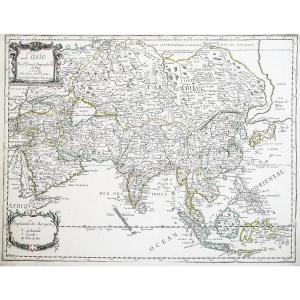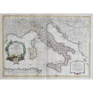


Old Map Of Italy
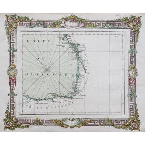
Epreuve originale réalisée en 1762. Jean Janvier cartographe.
Limites colorées de l’époque.
Très bon état.
Format feuille : 51 x 38,5 cm.
Format gravure : 46 x 32 cm.
Original antique map of 1762.
Echelle des lieux. Cartouche de titre décoratif.
Vous pouvez consulter l’ensemble des cartes, livres et gravures disponibles sur votre région en cliquant sur le lien de notre site internet spécialisé en archives anciennes géographiques :
https://cartes-livres-anciens.com/categorie-produit/cartes-geographiques-anciennes-original-antique-maps/europe/italie/
Règlement sécurisé par carte bancaire sur notre site internet en cliquant sur le lien ci-dessous :
https://cartes-livres-anciens.com/produit/cartes-geographiques-anciennes-original-antique-maps/europe/italie/carte-ancienne-de-litalie-3/
Toutes nos cartes et gravures sont accompagnées d’un certificat d’authenticité.
Jean Janvierétait un cartographe français qui travailla à Paris dans la seconde moitié du XVIIIe siècle. Parmi ses œuvres figurent de belles cartes parues dans l’Atlas Moderne de Jean Lattré . Cet atlas contenait des cartes du monde entier, gravées par Lattré, graveur ordinaire du Roi. Les cartes de Janvier présentaient les meilleures informations disponibles à l’époque.
Original print made in 1762. Jean Janvier, cartographer. Contemporary colored borders. Very good condition. Sheet size: 51 x 38.5 cm. Image size: 46 x 32 cm. Original antique map of 1762. Scale of locations. Decorative title cartouche. You can view all the maps, books, and engravings available for your region by clicking on the link to our website specializing in antique geographical archives: https://cartes-livres-anciens.com/categorie-produit/cartes-geographiques-anciennes-original-antique-maps/europe/italie/ Secure payment by credit card on our website by clicking on the link below: https://cartes-livres-anciens.com/produit/cartes-geographiques-anciennes-original-antique-maps/europe/italie/carte-ancienne-de-litalie-3/ All our maps and engravings come with a certificate of authenticity. Jean Janvier was a French cartographer who worked in Paris in the second half of the 18th century. Among his works are beautiful maps published in Jean Lattré's Atlas Moderne. This atlas contained maps of the entire world, engraved by Lattré, the King's engraver. The January maps presented the best information available at the time.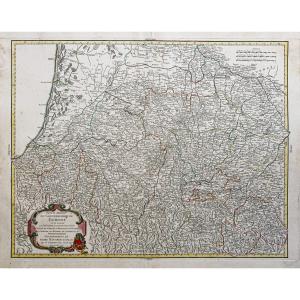
200 €
Period: 18th century
Style: Other Style
Condition: Excellent condition
Material: Paper
Reference (ID): 1691636
Availability: In stock
Print