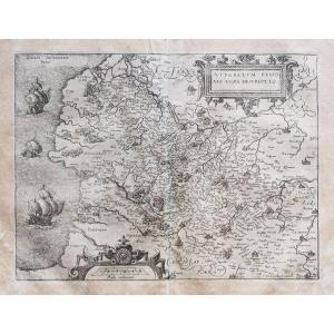
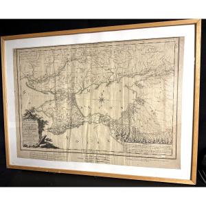
Old Geographical Map Of Sardinia
Beaux coloris anciens.
Marge latérale gauche rapportée anciennement.
Texte explicatif en vieux français au verso.
Très bon état.
Format feuille : 47,5 x 27,5 cm.
Format gravure : 34,5 x 22,5 cm.
Original antique map of 1636
Vous pouvez consulter l’ensemble des cartes, livres et gravures disponibles sur votre région en cliquant sur le lien de notre site internet spécialisé en archives anciennes géographiques : https://cartes-livres-anciens.com/categorie-produit/cartes-geographiques-anciennes-original-antique-maps/europe/italie/
Règlement sécurisé par carte bancaire sur notre site internet en cliquant sur le lien ci-dessous : https://cartes-livres-anciens.com/produit/cartes-geographiques-anciennes-original-antique-maps/europe/italie/carte-geographique-ancienne-de-la-sardaigne/
Toutes nos cartes et gravures sont accompagnées d’un certificat d’authenticité.
MERCATOR
Pendant près de soixante ans, au cours de la période la plus importante et la plus passionnante de l’histoire de la cartographie moderne, Gérard Mercator fut le cartographe suprême.
Son nom venait juste après Ptolémée, synonyme de la forme de projection cartographique encore utilisée aujourd’hui. Bien que n’étant pas l’inventeur de ce type de projection, il a été le premier à l’appliquer aux cartes de navigation sous une forme telle que les relèvements au compas puissent être tracés sur des cartes en ligne droite, offrant ainsi aux marins une solution à un problème de navigation de longue date en mer.
Son influence transforma l’arpentage, et ses recherches et calculs le conduisirent à rompre avec la conception qu’avait laissé Ptolémée, de la taille et de la silhouette des continents, réduisant radicalement la longueur longitudinale de l’Europe et de l’Asie et modifiant la forme de l’Ancien Monde, telle que visualisée au début du XVIe siècle.
Mercator est née à Rupelmonde en Flandre et a étudié à Louvain auprès de Gemma Frisius, écrivaine, astronome et mathématicienne néerlandaise. Il s’y établit en tant que cartographe, créateur d’instruments et de globe, et à vingt-cinq ans, dessine et grave sa première carte (de Palestine) et produit ensuite une carte de Flandre (1540) . L’excellence de son travail lui valut le patronage de Charles V pour lequel il construisit un globe.
Malgré sa faveur auprès de l’Empereur, il fut pris dans la persécution des protestants luthériens et accusé d’hérésie, heureusement sans conséquences graves.
Nul doute que la crainte de nouvelles persécutions ait influencé son déménagement à Duisburg en 1552, où il poursuivit la production de cartes, de globes et d’instruments aboutissant aux cartes à grande échelle de l’Europe (1554), des îles Britanniques (1564) et de la célèbre Carte du monde 18 feuilles dessinées à sa nouvelle projection (1569). Toutes ces premières cartes sont extrêmement rares, certaines ne sont connues que par un seul exemplaire.
Original proof made in 1636. Gérard Mercator geographer. Beautiful old colors. Left side margin brought back previously. Explanatory text in old French on the back. Very good condition. Sheet format: 47.5 x 27.5 cm. Engraving format: 34.5 x 22.5 cm. Original antique map of 1636 You can consult all the maps, books and engravings available in your region by clicking on the link to our website specializing in old geographical archives: https://cartes-livres-anciens.com/categorie-produit/cartes-geographiques-anciennes-original-antique-maps/europe/italie/ Secure payment by credit card on our website by clicking on the link below: https://cartes-livres-anciens.com/produit/cartes-geographiques-anciennes-original-antique-maps/europe/italie/carte-geographique-ancienne-de-la-sardaigne/ All our maps and engravings are accompanied by a certificate of authenticity.MERCATORFor nearly sixty years, during the most important and exciting period in the history of modern cartography, Gerard Mercator was the supreme cartographer. His name was second only to Ptolemy, synonymous with the form of map projection still used today. Although not the inventor of this type of projection, he was the first to apply it to navigational charts in such a form that compass bearings could be plotted on charts in a straight line, thus providing mariners with a solution to a long-standing problem of navigation at sea. His influence transformed surveying, and his research and calculations led him to break with Ptolemy's conception of the size and outline of continents, radically reducing the longitudinal length of Europe and Asia and changing the shape of the Old World, as visualized in the early 16th century. Mercator was born in Rupelmonde in Flanders and studied in Leuven under Gemma Frisius, a Dutch writer, astronomer, and mathematician. There he established himself as a cartographer, instrument maker, and globe maker, and at the age of twenty-five drew and engraved his first map (of Palestine) and subsequently produced a map of Flanders (1540). The excellence of his work earned him the patronage of Charles V, for whom he constructed a globe. Despite his favor with the Emperor, he was caught up in the persecution of Lutheran Protestants and accused of heresy, fortunately without serious consequences. No doubt the fear of further persecution influenced his move to Duisburg in 1552, where he continued the production of maps, globes, and instruments, culminating in the large-scale maps of Europe (1554), the British Isles (1564), and the famous 18-sheet Map of the World drawn to its new projection (1569). All of these early maps are extremely rare, some known from only a single copy.
Period: 17th century
Style: Other Style
Condition: Excellent condition
Material: Paper
Reference (ID): 1599892
Availability: In stock