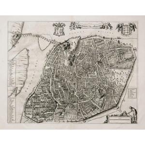


Old Geographical Map – Holland
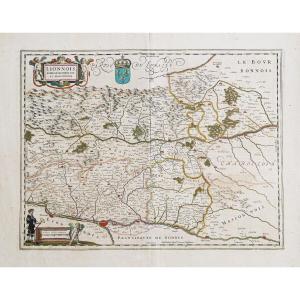
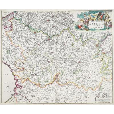
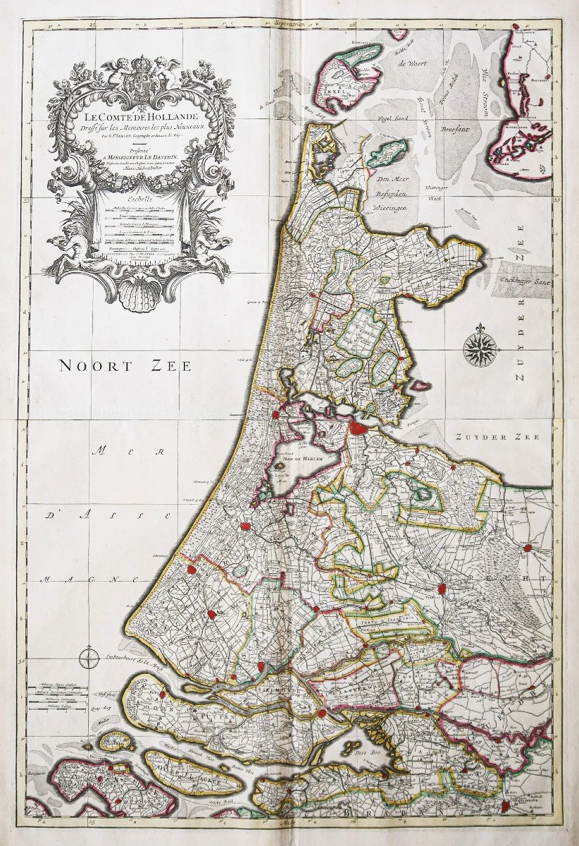
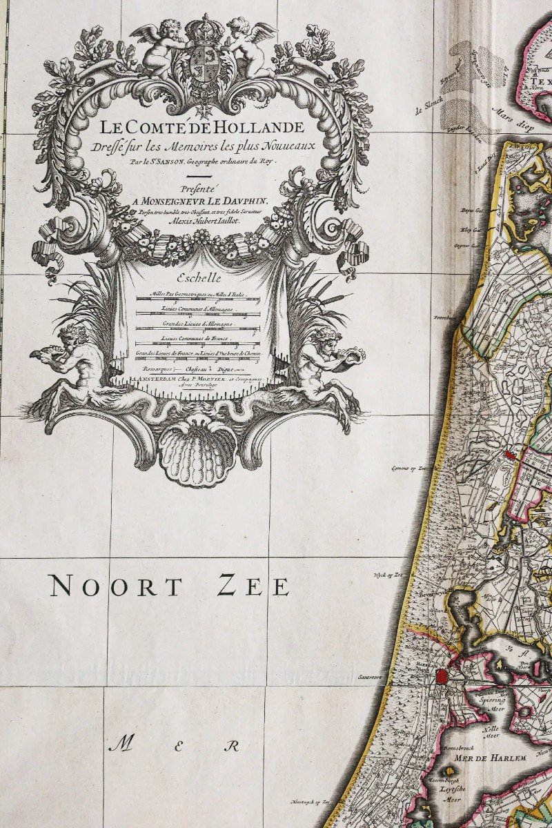
Epreuve originale réalisée vers 1720. Par Jaillot chez Mortier.
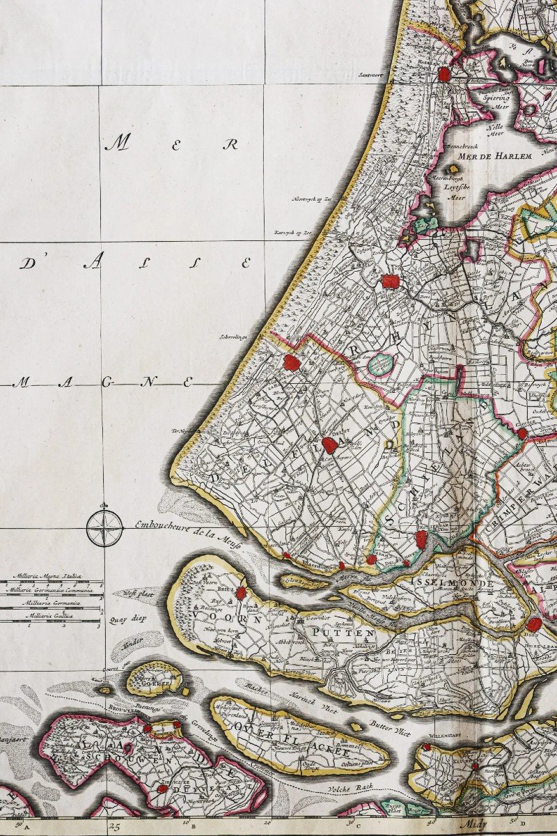
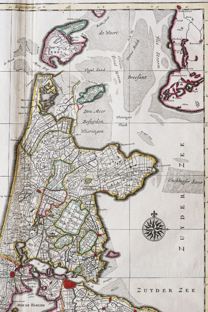
Limites colorées de l’époque.
Bon état général.
Format feuille : 92,5 x 60 cm.
Format gravure : 84 x 56,5 cm.
Original antique map around 1720.
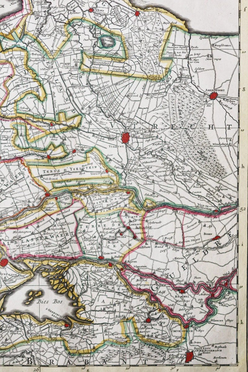
Splendide carte réalisée sur 2 feuillets joints. Large cartouche de titre surplombant l’échelle des lieux. 2 boussoles.
Vous pouvez consulter l’ensemble des cartes, livres et gravures disponibles sur votre région en cliquant sur le lien de notre site internet spécialisé en archives anciennes géographiques :
https://cartes-livres-anciens.com/categorie-produit/cartes-geographiques-anciennes-original-antique-maps/europe/paysbas-belgique-luxembourg/
Règlement sécurisé par carte bancaire sur notre site internet en cliquant sur le lien ci-dessous :
https://cartes-livres-anciens.com/produit/cartes-geographiques-anciennes-original-antique-maps/europe/paysbas-belgique-luxembourg/carte-geographique-ancienne-hollande-2/
Toutes nos cartes et gravures sont accompagnées d’un certificat d’authenticité.
Alexis-Hubert Jaillot (1632-1712) est un ingénieur géographe et cartographe français, imprimeur à Paris, de la fin du XVIIe siècle et du début du XVIIIe siècle, au service du roi Louis XIV.
« Les plus grandes cartes du 17ème siècle »
Il publie de nombreux travaux de géographes contemporains ainsi que ses propres œuvres.
« L’Atlas François », Jaillot, 1692-1695, compilation des cartes de Nicolas Sanson (cartographe), Édité à Paris et à Amsterdam chez R. et J. Ottens.
Son travail sera continué par son fils, Bernard Jean Hyacinthe Jaillot (1673-1739), son petit-fils, Bernard Antoine Jaillot, ainsi que le beau-frère de celui-ci, Jean Baptiste-Michel Renou de Chauvigné dit Jaillot (1710-1780).
Pieter et David MORTIER étaient des frères d’origine française dont les publications couvraient un vaste domaine englobant les œuvres françaises et anglaises ainsi que néerlandaises. Pieter a probablement été formé à la vente de livres et de cartes géographiques à Paris et David a passé de nombreuses années en Angleterre ; en fait, il acquit la nationalité britannique et mourut vers 1728 environ. Après le décès de Pieter, sa veuve poursuivit ses activités jusqu’à ce que leur fils, Cornelis, soit en mesure de prendre la relève. Puis, en 1721, Cornelis s’associa avec son beau-frère, Johannes Covens, pour former le célèbre nom Covens and Mortier, une entreprise qui conserva un léger changement de nom jusqu’au milieu du XIXe siècle.
Original proof made around 1720. By Jaillot at Mortier. Colorful boundaries of the time. Good condition. Sheet size: 92.5 x 60 cm. Engraving format: 84 x 56.5 cm. Original antique map around 1720. Splendid map produced on 2 attached sheets. Large title block overlooking the scale of the place. 2 compasses. You can consult all the maps, books and engravings available in your region by clicking on the link to our website specializing in ancient geographical archives: https://cartes-livres-anciens.com/categorie-produit/cartes-gegraphiques -Ancienes-original-antique-maps/europe/paysbas-belgique-luxembourg/ Secure payment by credit card on our website by clicking on the link below: https://cartes-livres-anciens.com/produit/cartes -geographic-old-original-antique-maps/europe/paysbas-belgique-luxembourg/geographic-map-old-holland-2/ All our maps and engravings are accompanied by a certificate of authenticity. Alexis-Hubert Jaillot (1632-1712) was a French geographical engineer and cartographer, printer in Paris, from the end of the 17th century and the beginning of the 18th century, in the service of King Louis XIV. “The greatest maps of the 17th century” He publishes numerous works by contemporary geographers as well as his own works. “L'Atlas François”, Jaillot, 1692-1695, compilation of maps by Nicolas Sanson (cartographer), Published in Paris and Amsterdam by R. and J. Ottens. His work will be continued by his son, Bernard Jean Hyacinthe Jaillot (1673-1739), his grandson, Bernard Antoine Jaillot, as well as his brother-in-law, Jean Baptiste-Michel Renou de Chauvigné dit Jaillot (1710- 1780). Pieter and David MORTIER were brothers of French origin whose publications covered a vast area encompassing French and English as well as Dutch works. Pieter was probably trained in selling books and maps in Paris and David spent many years in England; in fact, he acquired British citizenship and died around 1728 or so. After Pieter's death, his widow continued his activities until their son, Cornelis, was able to take over. Then, in 1721, Cornelis joined forces with his brother-in-law, Johannes Covens, to form the famous Covens and Mortier, a company that retained a slight name change until the mid-19th century.
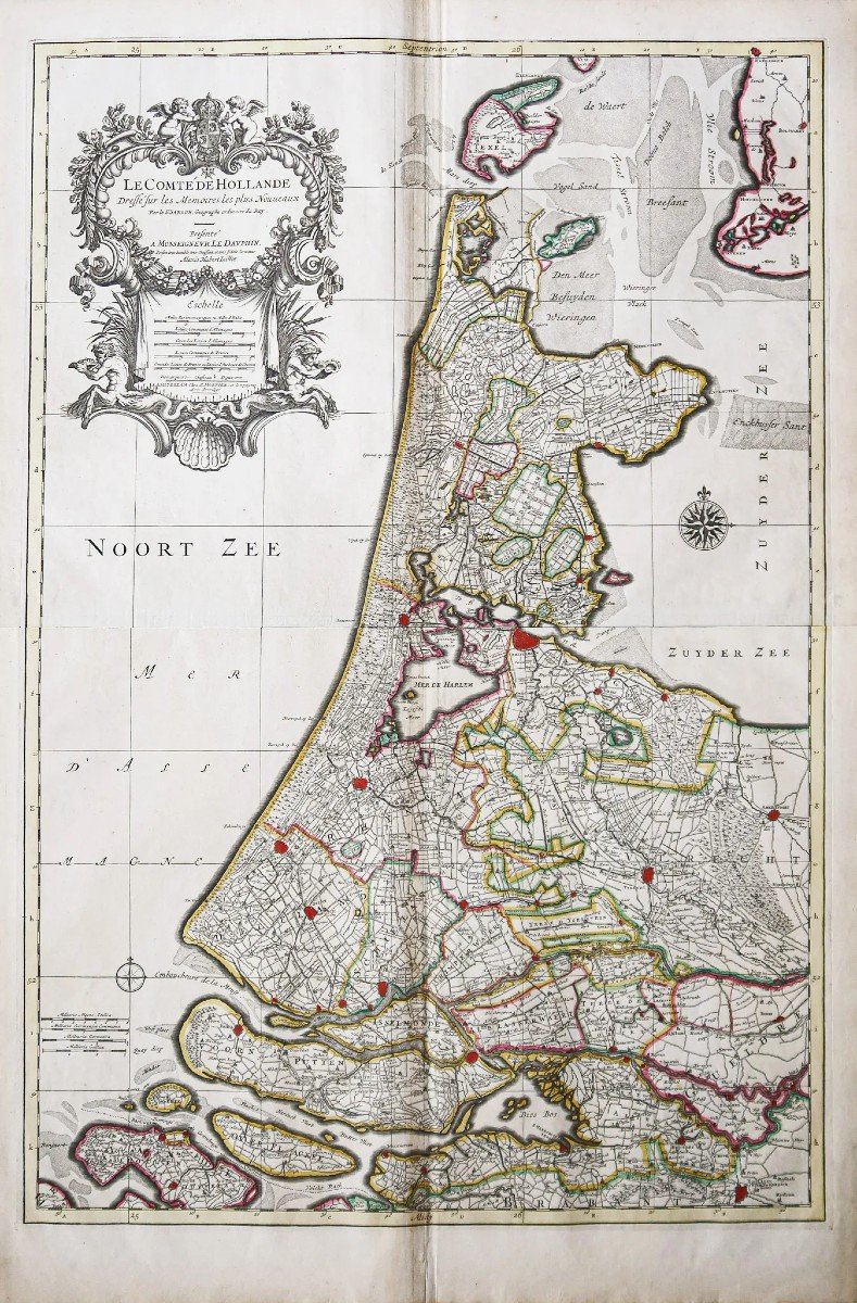
Limites colorées de l’époque.
Bon état général.
Format feuille : 92,5 x 60 cm.
Format gravure : 84 x 56,5 cm.
Original antique map around 1720.
Splendide carte réalisée sur 2 feuillets joints. Large cartouche de titre surplombant l’échelle des lieux. 2 boussoles.
Vous pouvez consulter l’ensemble des cartes, livres et gravures disponibles sur votre région en cliquant sur le lien de notre site internet spécialisé en archives anciennes géographiques :
https://cartes-livres-anciens.com/categorie-produit/cartes-geographiques-anciennes-original-antique-maps/europe/paysbas-belgique-luxembourg/
Règlement sécurisé par carte bancaire sur notre site internet en cliquant sur le lien ci-dessous :
https://cartes-livres-anciens.com/produit/cartes-geographiques-anciennes-original-antique-maps/europe/paysbas-belgique-luxembourg/carte-geographique-ancienne-hollande-2/
Toutes nos cartes et gravures sont accompagnées d’un certificat d’authenticité.
Alexis-Hubert Jaillot (1632-1712) est un ingénieur géographe et cartographe français, imprimeur à Paris, de la fin du XVIIe siècle et du début du XVIIIe siècle, au service du roi Louis XIV.
« Les plus grandes cartes du 17ème siècle »
Il publie de nombreux travaux de géographes contemporains ainsi que ses propres œuvres.
« L’Atlas François », Jaillot, 1692-1695, compilation des cartes de Nicolas Sanson (cartographe), Édité à Paris et à Amsterdam chez R. et J. Ottens.
Son travail sera continué par son fils, Bernard Jean Hyacinthe Jaillot (1673-1739), son petit-fils, Bernard Antoine Jaillot, ainsi que le beau-frère de celui-ci, Jean Baptiste-Michel Renou de Chauvigné dit Jaillot (1710-1780).
Pieter et David MORTIER étaient des frères d’origine française dont les publications couvraient un vaste domaine englobant les œuvres françaises et anglaises ainsi que néerlandaises. Pieter a probablement été formé à la vente de livres et de cartes géographiques à Paris et David a passé de nombreuses années en Angleterre ; en fait, il acquit la nationalité britannique et mourut vers 1728 environ. Après le décès de Pieter, sa veuve poursuivit ses activités jusqu’à ce que leur fils, Cornelis, soit en mesure de prendre la relève. Puis, en 1721, Cornelis s’associa avec son beau-frère, Johannes Covens, pour former le célèbre nom Covens and Mortier, une entreprise qui conserva un léger changement de nom jusqu’au milieu du XIXe siècle.
Original proof made around 1720. By Jaillot at Mortier. Colorful boundaries of the time. Good condition. Sheet size: 92.5 x 60 cm. Engraving format: 84 x 56.5 cm. Original antique map around 1720. Splendid map produced on 2 attached sheets. Large title block overlooking the scale of the place. 2 compasses. You can consult all the maps, books and engravings available in your region by clicking on the link to our website specializing in ancient geographical archives: https://cartes-livres-anciens.com/categorie-produit/cartes-gegraphiques -Ancienes-original-antique-maps/europe/paysbas-belgique-luxembourg/ Secure payment by credit card on our website by clicking on the link below: https://cartes-livres-anciens.com/produit/cartes -geographic-old-original-antique-maps/europe/paysbas-belgique-luxembourg/geographic-map-old-holland-2/ All our maps and engravings are accompanied by a certificate of authenticity. Alexis-Hubert Jaillot (1632-1712) was a French geographical engineer and cartographer, printer in Paris, from the end of the 17th century and the beginning of the 18th century, in the service of King Louis XIV. “The greatest maps of the 17th century” He publishes numerous works by contemporary geographers as well as his own works. “L'Atlas François”, Jaillot, 1692-1695, compilation of maps by Nicolas Sanson (cartographer), Published in Paris and Amsterdam by R. and J. Ottens. His work will be continued by his son, Bernard Jean Hyacinthe Jaillot (1673-1739), his grandson, Bernard Antoine Jaillot, as well as his brother-in-law, Jean Baptiste-Michel Renou de Chauvigné dit Jaillot (1710- 1780). Pieter and David MORTIER were brothers of French origin whose publications covered a vast area encompassing French and English as well as Dutch works. Pieter was probably trained in selling books and maps in Paris and David spent many years in England; in fact, he acquired British citizenship and died around 1728 or so. After Pieter's death, his widow continued his activities until their son, Cornelis, was able to take over. Then, in 1721, Cornelis joined forces with his brother-in-law, Johannes Covens, to form the famous Covens and Mortier, a company that retained a slight name change until the mid-19th century.
750 €
Period: 18th century
Style: Other Style
Condition: Excellent condition
Material: Paper
Reference (ID): 1208825
Availability: In stock
Print