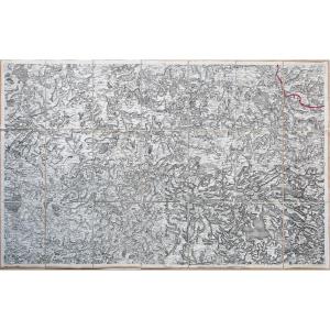
Old Map – Passage Through The Alps
Epreuve originale réalisée vers 1780. Liébaux Henri Auteur.
Beaux coloris anciens.
Très bon état.
Format feuille : 42 x 25 cm.
Format gravure : 29,5 x 22,5 cm.
Original map around 1780.
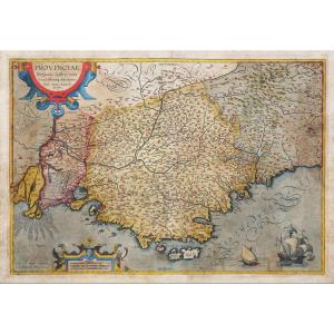
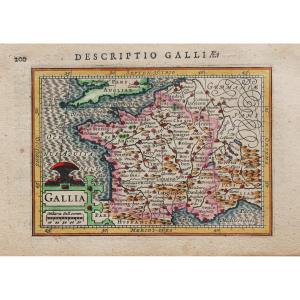
Echelle des lieux. Cartouche de titre illustré. Carte de la route d’Annibal dans les Gaules et de son passage en Italie. Le passage des Alpes par Hannibal est une étape majeure de la marche vers l’Italie de l’armée d’Hannibal Barca, réalisée à la fin de l’année 218 av J-C, au début de la deuxième guerre punique déclenchée contre Rome. Ce périple précis s’étala sur quinze jours, pour approximativement deux cents kilomètres parcourus.
Vous pouvez consulter l’ensemble des cartes, livres et gravures disponibles sur votre région en cliquant sur le lien de notre site internet spécialisé en archives anciennes géographiques :
https://cartes-livres-anciens.com/categorie-produit/cartes-geographiques-anciennes-original-antique-maps/france/provence-cote-dazur/
Règlement sécurisé par carte bancaire sur notre site internet en cliquant sur le lien ci-dessous :
https://cartes-livres-anciens.com/produit/cartes-geographiques-anciennes-original-antique-maps/europe/italie/carte-geographique-ancienne-passage-des-alpes/
Toutes nos cartes et gravures sont accompagnées d’un certificat d’authenticité.
Original print made around 1780. Author: Henri Liébaux. Beautiful original coloring. Very good condition. Sheet size: 42 x 25 cm. Image size: 29.5 x 22.5 cm. Original map circa 1780. Scale of locations. Illustrated title cartouche. Map of Hannibal's route through Gaul and his crossing into Italy. Hannibal's crossing of the Alps was a major stage in the march to Italy by Hannibal Barca's army, undertaken at the end of 218 BC, at the beginning of the Second Punic War against Rome. This specific journey took place over fifteen days, covering approximately two hundred kilometers. You can view all the maps, books, and engravings available for your region by clicking on the link to our website specializing in antique geographical archives: https://cartes-livres-anciens.com/categorie-produit/cartes-geographiques-anciennes-original-antique-maps/france/provence-cote-dazur/ Secure payment by credit card is available on our website by clicking on the link below: https://cartes-livres-anciens.com/produit/cartes-geographiques-anciennes-original-antique-maps/europe/italie/carte-geographique-ancienne-passage-des-alpes/ All our maps and engravings come with a certificate of authenticity.
Beaux coloris anciens.
Très bon état.
Format feuille : 42 x 25 cm.
Format gravure : 29,5 x 22,5 cm.
Original map around 1780.
Echelle des lieux. Cartouche de titre illustré. Carte de la route d’Annibal dans les Gaules et de son passage en Italie. Le passage des Alpes par Hannibal est une étape majeure de la marche vers l’Italie de l’armée d’Hannibal Barca, réalisée à la fin de l’année 218 av J-C, au début de la deuxième guerre punique déclenchée contre Rome. Ce périple précis s’étala sur quinze jours, pour approximativement deux cents kilomètres parcourus.
Vous pouvez consulter l’ensemble des cartes, livres et gravures disponibles sur votre région en cliquant sur le lien de notre site internet spécialisé en archives anciennes géographiques :
https://cartes-livres-anciens.com/categorie-produit/cartes-geographiques-anciennes-original-antique-maps/france/provence-cote-dazur/
Règlement sécurisé par carte bancaire sur notre site internet en cliquant sur le lien ci-dessous :
https://cartes-livres-anciens.com/produit/cartes-geographiques-anciennes-original-antique-maps/europe/italie/carte-geographique-ancienne-passage-des-alpes/
Toutes nos cartes et gravures sont accompagnées d’un certificat d’authenticité.
Original print made around 1780. Author: Henri Liébaux. Beautiful original coloring. Very good condition. Sheet size: 42 x 25 cm. Image size: 29.5 x 22.5 cm. Original map circa 1780. Scale of locations. Illustrated title cartouche. Map of Hannibal's route through Gaul and his crossing into Italy. Hannibal's crossing of the Alps was a major stage in the march to Italy by Hannibal Barca's army, undertaken at the end of 218 BC, at the beginning of the Second Punic War against Rome. This specific journey took place over fifteen days, covering approximately two hundred kilometers. You can view all the maps, books, and engravings available for your region by clicking on the link to our website specializing in antique geographical archives: https://cartes-livres-anciens.com/categorie-produit/cartes-geographiques-anciennes-original-antique-maps/france/provence-cote-dazur/ Secure payment by credit card is available on our website by clicking on the link below: https://cartes-livres-anciens.com/produit/cartes-geographiques-anciennes-original-antique-maps/europe/italie/carte-geographique-ancienne-passage-des-alpes/ All our maps and engravings come with a certificate of authenticity.
155 €
Period: 18th century
Style: Other Style
Condition: Excellent condition
Material: Paper
Reference (ID): 1697599
Availability: In stock
Print