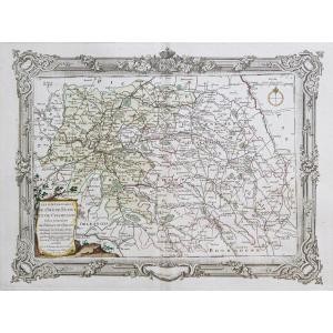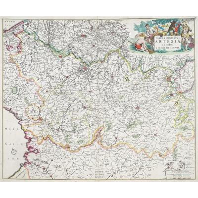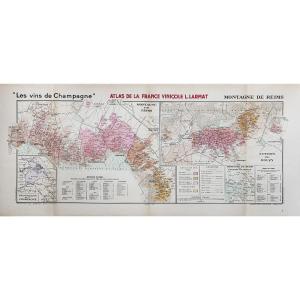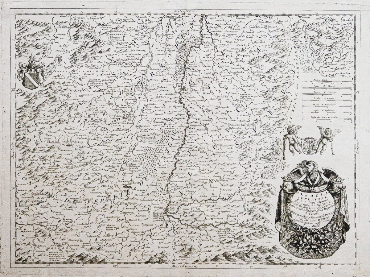
Antique Map Of Alsace
Épreuve originale réalisée vers 1690. Coronelli cartographe.
Greffe de papier sur 1cm x 5 cm dans l’angle supérieur gauche de la marge loin de la carte.
2 oxydations dans les marges latérales.
Bon état.
Format feuille : 67,5 x 51 cm.
Format gravure : 63,5 x 47 cm.
Original antique map around 1690.
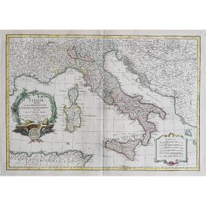
Belle carte originale de Coronelli, cartographe particulier de Louis XIV.
La carte est embellie d’un large cartouche de titre parfaitement gravé à l’eau-forte.
2 angelots portent de blason de l’Alsace. Echelle des lieux.
Vous pouvez consulter l’ensemble des cartes, livres et gravures disponibles sur votre région en cliquant sur le lien de notre site internet spécialisé en archives anciennes géographiques :
https://cartes-livres-anciens.com/categorie-produit/cartes-geographiques-anciennes-original-antique-maps/france/alsace-lorraine/
Règlement sécurisé par carte bancaire sur notre site internet en cliquant sur le lien ci-dessous :
https://cartes-livres-anciens.com/produit/cartes-geographiques-anciennes-original-antique-maps/france/alsace-lorraine/carte-geographique-ancienne-de-lalsace-5/
Toutes nos cartes et gravures sont accompagnées d’un certificat d’authenticité.
CORONELLI Vincenzo Mario : (1650 – 1718), Célèbre cartographe italien, fondateur de l’Académie Cosmographique de Argonauti (1680).
Cartographe de Louis XIV, il tranchera avec beaucoup de dextérité les travaux existant de ce 17ème siècle.
Les cartes sont d’une grande pureté, imprimées sur un splendide papier chiffon, le trait est vif, le seul cartographe à utiliser tous les atouts de l’eau-forte et à finalement rendre la géographie « artistique ».
Original proof by Coronelli, cartographer, circa 1690.
Paper scratch on 1cm x 5 cm in the upper left corner of the margin away from the map.
2 oxidations in the side margins.
Good condition.
Sheet size: 67.5 x 51 cm.
Engraving size: 63.5 x 47 cm.
Original antique map around 1690.
Beautiful original map by Coronelli, private cartographer to Louis XIV.
The map is embellished with a large title cartouche perfectly engraved in etching.
2 cherubs bear the Alsace coat of arms. Scale of locations.
You can view all availablemaps, books and engravings available for your region by clicking on the linklink to our website specializing in old geographical archivesarchives:
https://cartes-livres-anciens.com/categorie-produit/cartes-geographiques-anciennes-original-antique-maps/france/alsace-lorraine/
Secure payment by credit cardon our website by clicking on the link below:
https://cartes-livres-anciens.com/produit/cartes-geographiques-anciennes-original-antique-maps/france/alsace-lorraine/carte-geographique-ancienne-de-lalsace-5/
All our maps and prints are accompanied by a credit card.our maps and engravings are accompanied by a certificate of authenticity.
CORONELLI Vincenzo Mario : (1650 - 1718), Famous Italian cartographer, founder of the Cosmographic Academy of Argonauti (1680).
Cartographer to Louis XIV, he cut through the existing works of the 17th century with great dexterity.
The maps are of great purity, printed on splendid rag paper, the line is vivid, the only cartographer to use all the advantages of etching and finally make geography "artistic".
Greffe de papier sur 1cm x 5 cm dans l’angle supérieur gauche de la marge loin de la carte.
2 oxydations dans les marges latérales.
Bon état.
Format feuille : 67,5 x 51 cm.
Format gravure : 63,5 x 47 cm.
Original antique map around 1690.
Belle carte originale de Coronelli, cartographe particulier de Louis XIV.
La carte est embellie d’un large cartouche de titre parfaitement gravé à l’eau-forte.
2 angelots portent de blason de l’Alsace. Echelle des lieux.
Vous pouvez consulter l’ensemble des cartes, livres et gravures disponibles sur votre région en cliquant sur le lien de notre site internet spécialisé en archives anciennes géographiques :
https://cartes-livres-anciens.com/categorie-produit/cartes-geographiques-anciennes-original-antique-maps/france/alsace-lorraine/
Règlement sécurisé par carte bancaire sur notre site internet en cliquant sur le lien ci-dessous :
https://cartes-livres-anciens.com/produit/cartes-geographiques-anciennes-original-antique-maps/france/alsace-lorraine/carte-geographique-ancienne-de-lalsace-5/
Toutes nos cartes et gravures sont accompagnées d’un certificat d’authenticité.
CORONELLI Vincenzo Mario : (1650 – 1718), Célèbre cartographe italien, fondateur de l’Académie Cosmographique de Argonauti (1680).
Cartographe de Louis XIV, il tranchera avec beaucoup de dextérité les travaux existant de ce 17ème siècle.
Les cartes sont d’une grande pureté, imprimées sur un splendide papier chiffon, le trait est vif, le seul cartographe à utiliser tous les atouts de l’eau-forte et à finalement rendre la géographie « artistique ».
Original proof by Coronelli, cartographer, circa 1690.
Paper scratch on 1cm x 5 cm in the upper left corner of the margin away from the map.
2 oxidations in the side margins.
Good condition.
Sheet size: 67.5 x 51 cm.
Engraving size: 63.5 x 47 cm.
Original antique map around 1690.
Beautiful original map by Coronelli, private cartographer to Louis XIV.
The map is embellished with a large title cartouche perfectly engraved in etching.
2 cherubs bear the Alsace coat of arms. Scale of locations.
You can view all availablemaps, books and engravings available for your region by clicking on the linklink to our website specializing in old geographical archivesarchives:
https://cartes-livres-anciens.com/categorie-produit/cartes-geographiques-anciennes-original-antique-maps/france/alsace-lorraine/
Secure payment by credit cardon our website by clicking on the link below:
https://cartes-livres-anciens.com/produit/cartes-geographiques-anciennes-original-antique-maps/france/alsace-lorraine/carte-geographique-ancienne-de-lalsace-5/
All our maps and prints are accompanied by a credit card.our maps and engravings are accompanied by a certificate of authenticity.
CORONELLI Vincenzo Mario : (1650 - 1718), Famous Italian cartographer, founder of the Cosmographic Academy of Argonauti (1680).
Cartographer to Louis XIV, he cut through the existing works of the 17th century with great dexterity.
The maps are of great purity, printed on splendid rag paper, the line is vivid, the only cartographer to use all the advantages of etching and finally make geography "artistic".
300 €
Period: 17th century
Style: Other Style
Condition: Good condition
Material: Paper
Reference (ID): 1764045
Availability: In stock
Print