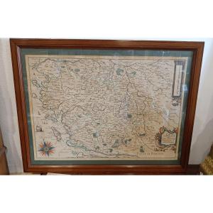
Old Map Of Corsica
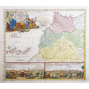
Grande épreuve originale réalisée en 1784. Jaillot cartographe, Santini éditeur.
Limites colorées de l’époque.
Très bon état.
Format feuille : 76 x 53 cm.
Format gravure : 67 x 49 cm.
Original antique map of 1784.
Belle impression sur papier fort. Cartouche de titre décoratif, agrémenté d’une tête de Maure, boussole, échelle des lieux. Remarques de A à P situant les différents fiefs et juridictions de l’île.
Encart illustrant la pointe du Cap Corse.
Vous pouvez consulter l’ensemble des cartes, livres et gravures disponibles sur votre région en cliquant sur le lien de notre site internet spécialisé en archives anciennes géographiques :
https://cartes-livres-anciens.com/categorie-produit/cartes-geographiques-anciennes-original-antique-maps/france/corse/
Règlement sécurisé par carte bancaire sur notre site internet en cliquant sur le lien ci-dessous :
https://cartes-livres-anciens.com/produit/cartes-geographiques-anciennes-original-antique-maps/france/corse/carte-geographique-ancienne-de-la-corse-11/
Toutes nos cartes et gravures sont accompagnées d’un certificat d’authenticité.
Alexis-Hubert Jaillot(1632-1712) est un ingénieur géographe et cartographe français, imprimeur à Paris, de la fin du XVIIe siècle et du début du XVIIIe siècle, au service du roi Louis XIV.
« Les plus grandes cartes du 17ème siècle »
Il publie de nombreux travaux de géographes contemporains ainsi que ses propres œuvres.
« L’Atlas François », Jaillot, 1692-1695, compilation des cartes de Nicolas Sanson (cartographe), Édité à Paris et à Amsterdam chez R. et J. Ottens.
Son travail sera continué par son fils, Bernard Jean Hyacinthe Jaillot (1673-1739), son petit-fils, Bernard Antoine Jaillot, ainsi que le beau-frère de celui-ci, Jean Baptiste-Michel Renou de Chauvigné dit Jaillot (1710-1780).
Large original proof made in 1784. Jaillot cartographer, Santini publisher. Contemporary colored borders. Very good condition. Sheet size: 76 x 53 cm. Image size: 67 x 49 cm. Original antique map of 1784. Beautiful impression on heavy paper. Decorative title cartouche, embellished with a Moor's head, compass, and scale of locations. Notes from A to P locating the different fiefs and jurisdictions of the island. Inset illustrating the tip of Cap Corse. You can consult all the maps, books and engravings available for your region by clicking on the link to our website specializing in old geographical archives: https://cartes-livres-anciens.com/categorie-produit/cartes-geographiques-anciennes-original-antique-maps/france/corse/ Secure payment by credit card on our website by clicking on the link below: https://cartes-livres-anciens.com/produit/cartes-geographiques-anciennes-original-antique-maps/france/corse/carte-geographique-ancienne-de-la-corse-11/ All our maps and engravings are accompanied by a certificate of authenticity. Alexis-Hubert Jaillot (1632-1712) was a French engineer, geographer and cartographer, printer in Paris, of the late 17th century. century and early 18th century, in the service of King Louis XIV. "The greatest maps of the 17th century" He published numerous works by contemporary geographers as well as his own works. "The French Atlas", Jaillot, 1692-1695, compilation of maps by Nicolas Sanson (cartographer), Published in Paris and Amsterdam by R. and J. Ottens. His work was continued by his son, Bernard Jean Hyacinthe Jaillot (1673-1739), his grandson, Bernard Antoine Jaillot, as well as the latter's brother-in-law, Jean Baptiste-Michel Renou de Chauvigné dit Jaillot (1710-1780).
850 €
Period: 18th century
Style: Other Style
Condition: Excellent condition
Material: Paper
Reference (ID): 1714056
Availability: In stock
Print