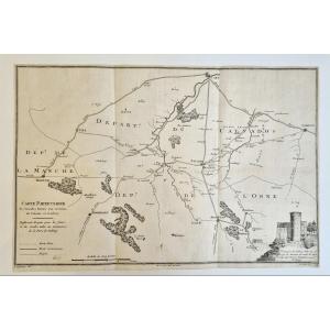
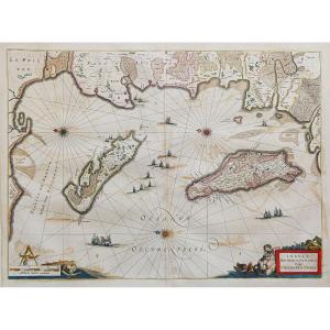
Large Map Of Japan, 1906-1915
Artist: Service Hydrographique De La Marine
Large map of Japan produced by the Navy's Hydraugraphic Service in 1906. This is the 1915 edition. This map represents exactly: "East Coast of Asia. Islands and Seas of Japan. Yellow Sea". The map is engraved by Vavasseur and Dumas Vorzet. Small tears at the folds, otherwise good condition. Rare map. Sheet size: 102x72cm. It is folded in two.
280 €
Period: 20th century
Style: Other Style
Condition: Condition of use
Material: Paper
Reference (ID): 1504128
Availability: In stock
Print