

Orignal Antique Plan City Of Aix En Provence
Epreuve originale réalisée vers 1680. Cundier Louis Auteur.
Fines traces de plis dans l’encadrement.
Classiques renforts au dos de la marge inférieure.
Bon état.
Format feuille : 51 x 41,5cm.
Orignal antique plan of 1680.
Vous pouvezconsulter l’ensemble des cartes et gravures disponibles sur votre région encliquant sur le lien de notre site internet spécialisé enarchives anciennes géographiques : https://cartes-livres-anciens.com/categorie-produit/cartes-geographiques-anciennes-original-antique-maps/france/provence-cote-dazur/
Règlement sécurisépar carte bancaire sur notre site internet en cliquant sur le lien : https://cartes-livres-anciens.com/produit/cartes-geographiques-anciennes-original-antique-maps/france/provence-cote-dazur/plan-ancien-de-la-ville-daix-en-provence/
Toutesnos cartes et gravures sont accompagnées d’un certificat d’authenticité.
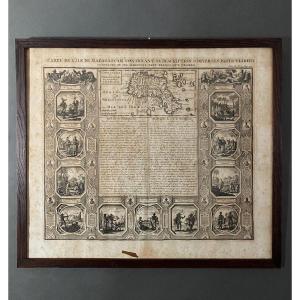
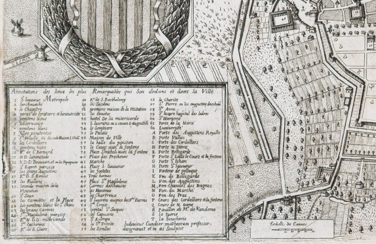
Rare plan géométrique de la ville d’Aix réalisé au 17ème siècle. Encart dans la partie inférieure gauche avec les annotations « des lieux les plus remarquables qui sont dedans et deors de la ville ». Grand blason de la ville, échelle des lieux.
Louis Cundier (1615 ? – 1681) fut un géomètre et graveur réputé de la ville d’Aix, suivant les traces de son beau-père, Jacques Maretz qui réalisa également un plan de la ville en 1624.
Original proof made around 1680. Cundier Louis Author. Fine traces of folds in the frame. Classic reinforcements on the back of the lower margin. Good condition. Sheet format: 51 x 41.5cm. Original antique plan of 1680. You can consult all the maps and engravings available on your region by clicking on the link of our website specialized in old geographical archives: https://cartes-livres-anciens.com/categorie-produit/cartes-geographiques-anciennes-original-antique-maps/france/provence-cote-dazur/ Secure payment by credit card on our website by clicking on the link: https://cartes-livres-anciens.com/produit/cartes-geographiques-anciennes-original-antique-maps/france/provence-cote-dazur/plan-ancien-de-la-ville-daix-en-provence/ All our maps and engravings are accompanied by a certificate of authenticity. Rare geometric plan of the city of Aix produced in the 17th century. Insert in the lower left part with the annotations "of the most remarkable places which are in and outside the city". Large coat of arms of the city, scale of the places. Louis Cundier (1615? – 1681) was a renowned surveyor and engraver of the city of Aix, following in the footsteps of his father-in-law, Jacques Maretz who also produced a plan of the city in 1624.
Fines traces de plis dans l’encadrement.
Classiques renforts au dos de la marge inférieure.
Bon état.
Format feuille : 51 x 41,5cm.
Orignal antique plan of 1680.
Vous pouvezconsulter l’ensemble des cartes et gravures disponibles sur votre région encliquant sur le lien de notre site internet spécialisé enarchives anciennes géographiques : https://cartes-livres-anciens.com/categorie-produit/cartes-geographiques-anciennes-original-antique-maps/france/provence-cote-dazur/
Règlement sécurisépar carte bancaire sur notre site internet en cliquant sur le lien : https://cartes-livres-anciens.com/produit/cartes-geographiques-anciennes-original-antique-maps/france/provence-cote-dazur/plan-ancien-de-la-ville-daix-en-provence/
Toutesnos cartes et gravures sont accompagnées d’un certificat d’authenticité.
Rare plan géométrique de la ville d’Aix réalisé au 17ème siècle. Encart dans la partie inférieure gauche avec les annotations « des lieux les plus remarquables qui sont dedans et deors de la ville ». Grand blason de la ville, échelle des lieux.
Louis Cundier (1615 ? – 1681) fut un géomètre et graveur réputé de la ville d’Aix, suivant les traces de son beau-père, Jacques Maretz qui réalisa également un plan de la ville en 1624.
Original proof made around 1680. Cundier Louis Author. Fine traces of folds in the frame. Classic reinforcements on the back of the lower margin. Good condition. Sheet format: 51 x 41.5cm. Original antique plan of 1680. You can consult all the maps and engravings available on your region by clicking on the link of our website specialized in old geographical archives: https://cartes-livres-anciens.com/categorie-produit/cartes-geographiques-anciennes-original-antique-maps/france/provence-cote-dazur/ Secure payment by credit card on our website by clicking on the link: https://cartes-livres-anciens.com/produit/cartes-geographiques-anciennes-original-antique-maps/france/provence-cote-dazur/plan-ancien-de-la-ville-daix-en-provence/ All our maps and engravings are accompanied by a certificate of authenticity. Rare geometric plan of the city of Aix produced in the 17th century. Insert in the lower left part with the annotations "of the most remarkable places which are in and outside the city". Large coat of arms of the city, scale of the places. Louis Cundier (1615? – 1681) was a renowned surveyor and engraver of the city of Aix, following in the footsteps of his father-in-law, Jacques Maretz who also produced a plan of the city in 1624.
1 500 €
Period: 17th century
Style: Other Style
Condition: Good condition
Material: Paper
Reference (ID): 1584029
Availability: In stock
Print