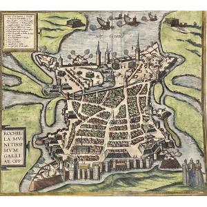
Mercator Historical Map: Vdrone Irlandiæ In Catherlagh Baronia, Carlow Ireland
Artist: Gérard Mercator (1512 - 1594)
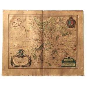
Mercator color map of the County Carlow region in southeastern Ireland, with decorative cartouche at bottom left.
Map engraved by Gerard MERCATOR, probably from the French edition of the atlas published by HONDIUS.
Gerardi Mercatoris - 1512-1594
Date of first edition: 1585, probable date of this map: 1628 - 1633.
Copperplate engraving, printed on paper.
Verso: French text: titled "LAVTABLE D'Irlande…" Very beautiful polychromy, very fine drawings and writings
Good condition: fold in the center, minimal tears, on the photo of the verso, it is the trace of the color of the country outline of the recto, not a trace of a halo.
Dimensions: sheet of 565 x 460 mm, engraving (plate) of 350 x 28.5 mm.
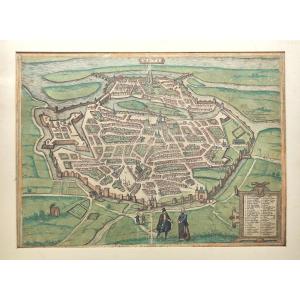
220 €
Period: 17th century
Style: Renaissance, Louis 13th
Condition: Excellent condition
Material: Paper
Length: 56,5 cm
Height: 46 cm
Reference (ID): 1562598
Availability: In stock
Print