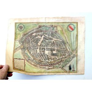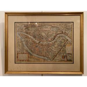


Map Of Metz Georg Braun And Frans Hogenberg
Artist: Georg Braun Et Frans Hogenberg
Plan of the city of Metz in 1572, taken from the book "Civitates Orbis Terrarum", and including 564 perspective views of the main cities of the world. The plan is framed in a pitch pine frame with ebony fillets from the 19th century. The dimensions of the bowl are 35.5x48 cm
280 €
Period: 16th century
Style: Renaissance, Louis 13th
Condition: Good condition
Material: Paper
Width: 54
Height: 41,5
Reference (ID): 1308615
Availability: In stock
Print