Plan de la ville et citadelle d’Anvers.Epreuve originale réalisée en 1711. Henri Fricz auteur.Belle impression bien contrastée.Très bon état.Format feuille : 58 x 42 cm.Format gravure : 53,5 x 39,5 cm[...]
Epreuve originale réalisée en 1705. Nicolas de Fer géographe.Rousseurs dans les marges n’atteignant pas le plan.Bon état.Format feuille : 42,5 x 30,5 cm.Format gravure : 39 x 28,5 cm.Original antique [...]
Rare and beautiful map circa 1679 of the bishopric of Luçon in Vendée, drawn up by Guillaume SANSON, son of Nicolas SANSON d'ABBEVILLE. It is decorated with three cartouches including a large title ca[...]
18th century watercolor map by Rigobert Bonne titled "Map of the Regions and Places spoken of in the New Testament" representing the entire Mediterranean basin at the time of the Gospels. Representati[...]
Carte originale réalisée en 1581. Abraham Ortelius cartographe.Belle impression. Coloris aquarelle.Explication de la carte en français au verso.Format feuille : 61,5 x 43,5 cm.Format cuivre : 57,5 x 3[...]
Original proof made around 1650. Jansson Johanne geographer. Antique colors. Explanatory text on the back in Spanish. Very good condition. Sheet size: 60 x 49.5 cm. Engraving size: 50 x 8.5 cm. Origin[...]
Epreuve originale réalisée en 1811. Chardin Jean auteur.Auréole et rousseur dans l’angle inférieur droit.Etat correct.Format feuille : 50 x 33,5 cm.Format gravure : 40 x 24 cm.Original antique engravi[...]
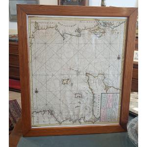
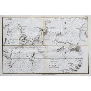
Large nautical chart "for the second part of the English Channel between England and France" circa 1680 by Van Keulen with: The French coasts of Normandy (Cotentin and Bessin) and northern Brittany (I[...]
Epreuve originale réalisée en 1705. Nicolas De Fer cartographe.Rousseurs claires dans la marge latérale gauche.Bon état.Format feuille : 40 x 28 cm.Original antique map of 1705.Ile, rocher, ville, châ[...]
Epreuve originale réalisée en 1784. Zatta cartographe.Beaux coloris anciens.Petite restauration de 1cm dans la marge latérale gauche, loin de la carte.1 trace de pli dans la marge inférieure.Bon état.[...]
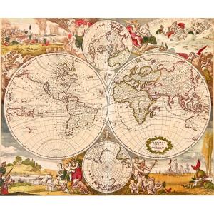
In Amsterdam in the late 1660s, Justus Danckerts created his first version of a decorative, double-page, double-hemisphere engraved world map, Nova Totius Terrarum Orbis Tabula. This finely colored ex[...]
This 19th century map was framed in the 20th century. We note stains and folds on the map. Our photos allow you to appreciate the quality of this map. For the condition, please detail the photos. Do n[...]
Epreuve originale réalisée en 1793. Faden éditeur.Beaux coloris aquarelle.2 mouillures dans la marge supérieure n’atteignant pas la carte.Très bon état.Format feuille : 37 x 27 cm.Format gravure : 35 [...]
Epreuve originale réalisée en 1728. Homann cartographe.Beaux coloris aquarelle.Fine oxydation dans le pli central.Très bon état.Format feuille : 63,5 x 53 cm.Format gravure : 58 x 49,5 cm.Original ant[...]
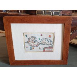
Rare watercolor map of the island of Noirmoutier from 1634 by Christophe TASSIN. Beautiful old colors with Cartouche at the bottom right "Isle de Narmoustier" and many ships. Old walnut frame 31.5 cm [...]
Rare General Map of Poitou, Xaintonge, Angoulmois and the Aulnix region" by Christophe TASSIN from the 17th century around 1634. Map engraved on paper and watercolored from the period (foxing and fold[...]
Epreuve originale réalisée en 1890.Impression en couleurs.Rousseurs claires éparses.Bon état.Format feuille : 65 x 49 cm.Original antique chart of 1890.Rare collection illustrant les ports de France.I[...]
Nouvelle carte géographique des postes et autres routes d’Allemagne, poussées jusque dans les Pays-Bas, en Suisse, en Italie, en Hongrie, en Pologne, en Prusse, au Danemark…Grande épreuve originale gr[...]
Belle épreuve sur grand papier réalisée vers 1750. Bellin cartographe.Coloris aquarelle.Très bon état.Format feuille : 48,5 x 33,5 cm.Format gravure : 23 x 18 cm.Original antique map around 1750Vous p[...]
Carte d’Italie, assujettie aux observations astronomiques et aux itinéraires comprenant toutes les grandes routes qui traversent les différents états de cette région, avec les distances par postes.Gra[...]
Very beautiful map of Europe engraved in 1754 by Jean-Baptiste d'ANVILLE (1697-1782). These are 2 plates engraved with etching and enhanced with watercolor measuring 51 x 83 cm (copper) and 55.5 x 84 [...]
Very beautiful map from 1763 showing the "Known World of the Ancients" ("Orbis veteribus notus") by Jean-Baptiste d'ANVILLE (1697-1782). It is an etching enhanced with watercolor measuring 54.5 x 77.5[...]
Very beautiful map showing a view of ILLYRIA/DALMATIA by Nicolas SANSON (1600-1667). This is an etching enhanced with watercolor measuring 42 x 53 cm (copper) and 46 x 60.5 cm (sheet). Free delivery i[...]
Very beautiful map showing a view of the EUPHRATES and the TIGER in 1779 by Jean-Baptiste d'ANVILLE (1697-1782). It is an etching enhanced with watercolor measuring 44.5 x 53 cm (copper) and 51.5 x 68[...]
Very beautiful etching by Jean-Baptiste d'ANVILLE (1697-1782) depicting a view of Egypt and Saudi Arabia in 1765. The work measures 69 x 41.5 cm (copper) and 72.5 x 56.5 cm (sheet). Free delivery in P[...]
Very beautiful map of Africa engraved by Jean-Baptiste d'ANVILLE (1697-1782) in 1772. It is an etching enhanced with watercolor measuring 53.5 x 124 cm (copper) and 55 x 127 cm (sheet). Free delivery [...]
Epreuve originale réalisée en 1705. Nicolas De Fer cartographe.Limites colorées de l’époque.1 pincement de papier ancien dans le cartouche de titre.Débord d’encre dans les légendes autour de la ville [...]
Épreuve originale réalisée vers 1710 chez Pierre Mortier à Amsterdam. Nicolas de Fer cartographe.Rousseurs claires dans les marges.Coloris aquarelle.Très bon état.Format feuille : 33,5 x 27,5 cm.Forma[...]
Petite carte d’Orient et de la Méditerranée.Epreuve originale réalisée en 1840. Ch. Avril graveur et Simon lithographe.Limites colorées de l’époque.Très bon état.Format feuille : 43,5 x 27,5 cm.Origin[...]
Epreuve originale réalisée vers 1770. Lotter cartographe.Beaux coloris anciens.Rousseurs et renforts au dos des marges latérales n’atteignant pas la carteBon état.Format feuille : 65,5 x 53,5 cm.Forma[...]
Giovanni Valle was a Venetian engraver and cartographer active in the late 18th and early 19th century. He is mainly known for his geographical engravings and maps that contributed to the great cartog[...]
Epreuve originale réalisée vers 1820. Benedetto Bordiga auteur.Infime manque de papier dans l’angle inférieur droit.Fines rousseurs claires au-dessus du Mont Blanc.2 renforts sur 1 cm au dos de la pre[...]
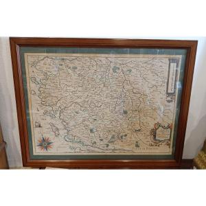
This map is old, it was framed in the 60s with protective glass. We note that the map is stained in places, traces of wear on the small golden element which fixes the tile. Our numerous photos allow y[...]
Original proof made around 1790. Delamarche cartographer. Beautiful watercolor colors. A light foxing in the lower margin far from the map. Very good condition. Sheet size: 77 x 59 cm. Engraving size:[...]
This color engraving is old. It was framed under glass in the 1960s. We note some foxing on the engraving and various small stains. The engraving remains, however, in acceptable but not perfect condit[...]
Epreuve originale réalisée vers 1680. Cundier Louis Auteur.Fines traces de plis dans l’encadrement.Classiques renforts au dos de la marge inférieure.Bon état.Format feuille : 51 x 41,5cm.Orignal antiq[...]
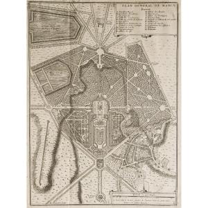
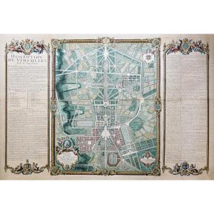
https://cartes-livres-anciens.com/produit/cartes-geographiques-anciennes-original-antique-maps/france/ile-de-france-78-versailles/plan-monumental-de-versailles-ville-et-chateau/Original plan from 1717[...]
Epreuve originale réalisée vers 1780. Denis et Patour éditeur.Fines traces de plis dans l’encadrement.Beaux coloris anciens.Bon état.Format feuille : 68 x 46 cm.Original antique map of 1780.Grande car[...]
Epreuve originale réalisée en 1898. Labouche frères éditeurs.Première édition.Impression en couleurs.1 rousseur dans la rue de la Chaine.Très bon état.Format feuille : 59 x 48,5 cm.Format replié : 13,[...]
Giovanni Maria Cassini 1745 – 1824
Six antique engravings from the "Nuovo Atlante Geografico Universale delineato sulle ultime osservazioni", published in Rome from 1792 to 1801: – World Map – Spheri[...]
Epreuve originale réalisée vers 1630. Johannes Jansson cartographe.Fines rousseurs dans la marge supérieure loin de la carte.Très beaux coloris anciensTexte explicatif au verso en vieux français.Très [...]
Carte ancienne gouvernement du DauphinéEpreuve originale réalisée vers 1710. De Witt cartographe.Limites colorées de l’époque.Très bon état.Format feuille : 62,5 x 53,5 cm.Format gravure : 60,5 x 50 c[...]
This color map is from the 18th century. It was framed under glass in the 1960s. It is in generally acceptable condition, but not perfect, with some foxing. Our photos allow you to appreciate the qual[...]
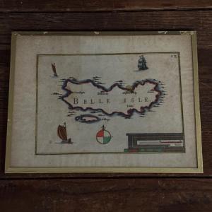
This color engraving is from the 17th century, it is authentic and old. It bears the inscription "Belle Isle" and the number 28 at the top right. It was framed under glass in the 1960s. You will notic[...]
Les élections de Tours, d’Amboise, de Loches, de Richelieu, de Chinon, de Bauge, de Montreuil Bellay et d’Angers, dans la généralité de Tours.Epreuve originale réalisée en 1711. Jaillot cartographe.Li[...]
Grand plan original réalisé en 1860.Entoilé d’époque et monté en 32 sections.Rousseurs claires éparses.Bon état.Format feuille : 111,5 x 94 cm.Format repliée : 24 x 14 cm.Original antique map of 1860.[...]
Grande épreuve originale réalisée en 1908. Publiée par la Compagnie Scarborough.Carte recto verso gravée sur papier parcheminé.Très belle impression en couleurs.Emboitage d’époque.traces de plis d'ori[...]
Rare historical document: Handwritten letter signed in 1786 by José Moñino y Redondo, better known as the Count of Floridablanca, a prominent 18th-century Spanish political figure and Minister of Stat[...]
Epreuve originale réalisée en 1899. Lecocq graveur.Impression en couleurs.Très bon état.Format feuille : 39 x 29 cm.Original antique map of 1899.Edition de la fin du 19ème siècle agrémentée d’un carto[...]
Title of the engraving, MONSPESSULANUS, MONTPELLIER. Copper engraving colored in watercolor, this copy seems to be one of the oldest, from 1575. The work, initially published in Latin around 1572 unde[...]
Carte géographique ancienne de la Perse – Iran Grande épreuve originale en seconde édition de 1785 par Dezauche.Limites colorées de l’époque.Très bon état.Format feuille : 82 x 57,5 cm.Format gravure[...]
Epreuve originale réalisée en 1867. Chez J. Rothschild éditeur.Beaux coloris aquarelle.Très bon état.Format feuille : 61 x 42,5 cm.Format gravure : 47,5 x 32,5 cm.Original antique engraving of 1867.Pl[...]
Proantic uses a cookie to analyze traffic and improve its service by using Google Analytics. Data sent to Google Analytics (frequency of visits to the site and pages visited) are anonymous. No other cookie tracks your activity, your personal data is not collected. Thank you for helping us to have better understanding how Proantic is used.


 Le Magazine de PROANTIC
 TRÉSORS Magazine
 Rivista Artiquariato