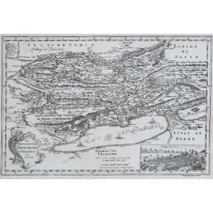
Color Map Of Gallia Antiqua, 19th Century
This 19th century map was framed in the 20th century. We note stains and folds on the map. Our photos allow you to appreciate the quality of this map. For the condition, please detail the photos. Do not hesitate to zoom in. The photos are an integral part of the description. Dimensions: Frame Height: 44 cm Width: 39 cm View Height: 25 cm Width: 20 cm L9220
200 €
Period: 19th century
Style: Other Style
Condition: Condition of use
Width: 39 cm
Height: 44 cm
Reference (ID): 1608199
Availability: In stock
Print