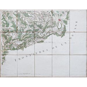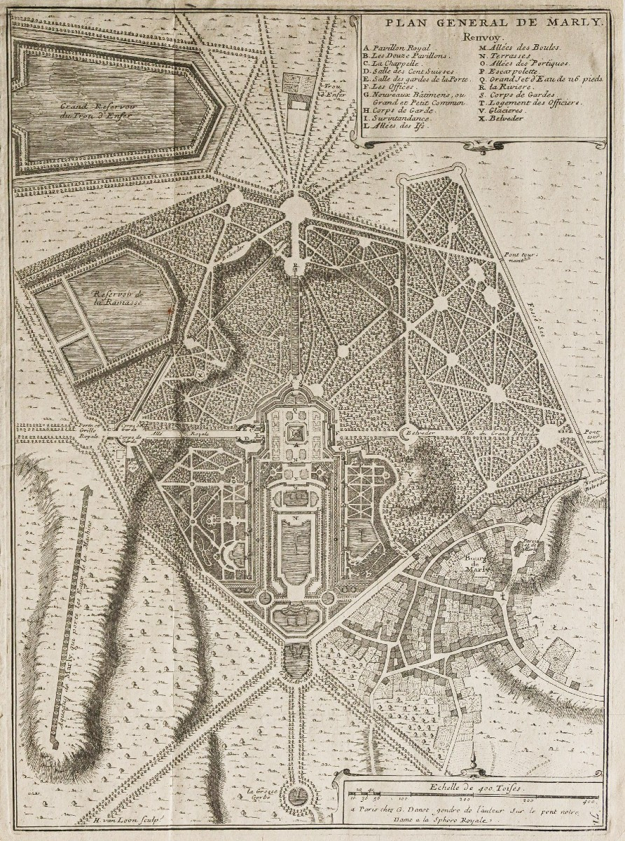


General Plan Of Marly Le Roi
Rousseurs dans les marges n’atteignant pas le plan.
Bon état.
Format feuille : 42,5 x 30,5 cm.
Format gravure : 39 x 28,5 cm.
Original antique engraving of 1705.
Beau plan des jardins du Château de Marly le Roi. Cartouche avec renvois de A à X situant les principaux lieux.
Vous pouvez consulter l’ensemble des cartes, livres et gravures disponibles sur votre région en cliquant sur le lien de notre site internet spécialisé en archives anciennes géographiques :
https://cartes-livres-anciens.com/categorie-produit/cartes-geographiques-anciennes-original-antique-maps/france/ile-de-france-78-versailles/
Règlement sécurisé par carte bancaire sur notre site internet en cliquant sur le lien ci-dessous :
https://cartes-livres-anciens.com/produit/cartes-geographiques-anciennes-original-antique-maps/france/ile-de-france-78-versailles/plan-general-de-marly-le-roi/
Toutes nos cartes et gravures sont accompagnées d’un certificat d’authenticité.
De Fer Nicolas 1647 – 1720
Géographe de Sa Majesté catholique 1702 et de Monseigneur le Dauphin 1690) et géographe des Enfants royaux.
Nicolas de Fer était Fils du marchand d’estampes Antoine de Fer. Il rentra en apprentissage à l’âge de 12 ans chez le graveur Louis Spirinx en mai 1659 puis travaille avec son père jusqu’à la mort de ce dernier en juin 1673, puis avec sa mère jusqu’en 1687, année où celle-ci lui cède son commerce (8 nov. 1687).
Ingénieur et cartographe, il emploiera plusieurs graveurs qui réaliseront ses cartes marines, la cartographie des conquêtes de Louis XIV, soit plus de 600 cartes ou plans dont la France politique, administrative, ecclésiastique, hydrographique, orographique, ainsi que divers pays limitrophes.
Son œuvre marquante résultera de la réunion des cartes dans l’Atlas Curieux où le Monde représenté dans les cartes générales et particulières du Ciel et de la Terre.
Original proof made in 1705. Nicolas de Fer geographer. Foxing in the margins not reaching the plan. Good condition. Sheet size: 42.5 x 30.5 cm. Engraving size: 39 x 28.5 cm. Original antique engraving of 1705. Beautiful plan of the gardens of the Château de Marly le Roi. Cartridge with references from A to X locating the main places. You can consult all the maps, books and engravings available in your region by clicking on the link to our website specializing in old geographical archives: https://cartes-livres-anciens.com/categorie-produit/cartes-geographiques-anciennes-original-antique-maps/france/ile-de-france-78-versailles/ Secure payment by credit card on our website by clicking on the link below: https://cartes-livres-anciens.com/produit/cartes-geographiques-anciennes-original-antique-maps/france/ile-de-france-78-versailles/plan-general-de-marly-le-roi/ All our maps and engravings are accompanied by a certificate of authenticity. De Fer Nicolas 1647 – 1720 Geographer of His Catholic Majesty 1702 and of Monseigneur the Dauphin 1690) and geographer of the Royal Children. Nicolas de Fer was the son of the print merchant Antoine de Fer. He entered an apprenticeship at the age of 12 with the engraver Louis Spirinx in May 1659 and then worked with his father until the latter's death in June 1673, then with his mother until 1687, the year in which she sold him her business (November 8, 1687). An engineer and cartographer, he employed several engravers who produced his nautical charts, the cartography of the conquests of Louis XIV, more than 600 maps or plans including political, administrative, ecclesiastical, hydrographic, orographic France, as well as various bordering countries. His significant work resulted from the collection of maps in the Curious Atlas where the World represented in the general and particular maps of Heaven and Earth.
Period: 18th century
Style: Other Style
Condition: Good condition
Material: Paper
Reference (ID): 1616705
Availability: In stock