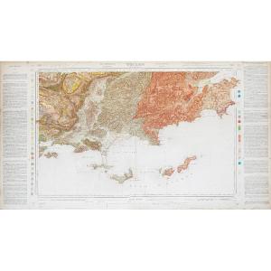
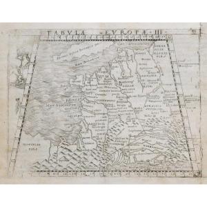
Old Geographical Map – Savoie - Alps
Artist: Nicolas De Fer
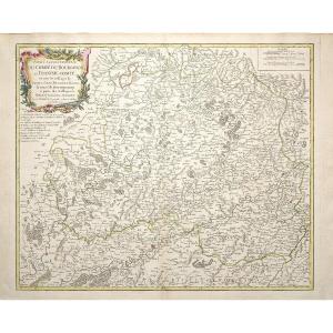
Epreuve originale réalisée en 1705. Nicolas De Fer cartographe.
Limites colorées de l’époque.
1 pincement de papier ancien dans le cartouche de titre.
Débord d’encre dans les légendes autour de la ville de Monaco.
Bon état.
Format feuille : 69,5 x 49,5 cm.
Format gravure : 65,5 x 45 cm.
Original antique map of 1705.
Carte peu courante qui s’étend de Milan, au lac de Côme et à l’est jusqu’aux régions de Nice, de Savoie, de Lyon et du lac Léman à l’ouest.
Large cartouche décoratif surmonté de scènes historiques illustrant les vallées de Perouse, De Pragelas, De St. Margtin, D’Angrogne et de Lucerne.
Vous pouvez consulter l’ensemble des cartes et gravures disponibles sur votre région en cliquant sur le lien de notre site internet spécialisé en archives anciennes géographiques : https://cartes-livres-anciens.com/categorie-produit/cartes-geographiques-anciennes-original-antique-maps/france/savoie/
Règlement sécurisé par carte bancaire sur notre site internet en cliquant sur le lien : https://cartes-livres-anciens.com/produit/cartes-geographiques-anciennes-original-antique-maps/europe/italie/carte-geographique-ancienne-savoie/
Toutes nos cartes et gravures sont accompagnées d’un certificat d’authenticité.
De Fer Nicolas 1647 – 1720
Géographe de Sa Majesté catholique 1702 et de Monseigneur le Dauphin 1690) et géographe des Enfants royaux.
Nicolas de Fer était Fils du marchand d’estampes Antoine de Fer. Il rentra en apprentissage à l’âge de 12 ans chez le graveur Louis Spirinx en mai 1659 puis travaille avec son père jusqu’à la mort de ce dernier en juin 1673, puis avec sa mère jusqu’en 1687, année où celle-ci lui cède son commerce (8 nov. 1687).
Ingénieur et cartographe, il emploiera plusieurs graveurs qui réaliseront ses cartes marines, la cartographie des conquêtes de Louis XIV, soit plus de 600 cartes ou plans dont la France politique, administrative, ecclésiastique, hydrographique, orographique, ainsi que divers pays limitrophes.
Son œuvre marquante résultera de la réunion des cartes dans l’Atlas Curieux où le Monde représenté dans les cartes générales et particulières du Ciel et de la Terre.
Original proof made in 1705. Nicolas De Fer cartographer. Coloured boundaries of the time. 1 pinch of old paper in the title cartouche. Ink overflow in the legends around the city of Monaco. Good condition. Sheet size: 69.5 x 49.5 cm. Engraving size: 65.5 x 45 cm. Original antique map of 1705. Uncommon map which extends from Milan, Lake Como and east to the regions of Nice, Savoy, Lyon and Lake Geneva to the west. Large decorative cartouche surmounted by historical scenes illustrating the valleys of Perugia, Pragelato, St. Margin, Angrogne and Lucerne. You can consult all the maps and engravings available on your region by clicking on the link of our website specializing in old geographical archives: https://cartes-livres-anciens.com/categorie-produit/cartes-geographiques-anciennes-original-antique-maps/france/savoie/ Secure payment by credit card on our website by clicking on the link: https://cartes-livres-anciens.com/produit/cartes-geographiques-anciennes-original-antique-maps/europe/italie/carte-geographique-ancienne-savoie/ All our maps and engravings are accompanied by a certificate of authenticity. Nicolas de Fer 1647 – 1720 Geographer of His Catholic Majesty 1702 and of Monseigneur the Dauphin 1690) and geographer of the Royal Children. Nicolas de Fer was the son of the print merchant Antoine de Fer. He entered an apprenticeship at the age of 12 with the engraver Louis Spirinx in May 1659 and then worked with his father until his death in June 1673, then with his mother until 1687, the year in which she sold him her business (8 November 1687). An engineer and cartographer, he employed several engravers who produced his nautical charts, the cartography of the conquests of Louis XIV, more than 600 maps or plans including political, administrative, ecclesiastical, hydrographic, orographic France, as well as various bordering countries. His significant work resulted from the collection of maps in the Atlas Curieux where the World represented in the general and particular maps of Heaven and Earth.
1 000 €
Period: 18th century
Style: Other Style
Condition: Good condition
Material: Paper
Reference (ID): 1595808
Availability: In stock
Print