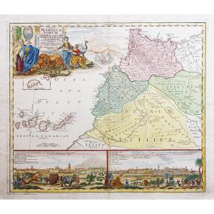


Old Map Of Morocco – Marrakech
Beaux coloris aquarelle.
Fine oxydation dans le pli central.
Très bon état.
Format feuille : 63,5 x 53 cm.
Format gravure : 58 x 49,5 cm.
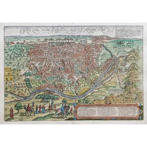
Original antique map of 1728.
Carte enluminée d’une vue de la ville de Marrakech et de Meknès avec renvois situant les principaux lieux et monuments de ces villes.
Large cartouche de titre et échelle des mesures.
Vous pouvez consulter l’ensemble des cartes et gravures disponibles sur votre région en cliquant sur le lien de notre site internet spécialisé en archives anciennes géographiques :
https://cartes-livres-anciens.com/categorie-produit/cartes-geographiques-anciennes-original-antique-maps/afrique/maroc/
Règlement sécurisé par carte bancaire sur notre site internet en cliquant sur le lien :
https://cartes-livres-anciens.com/produit/cartes-geographiques-anciennes-original-antique-maps/afrique/afrique-du-nord/carte-ancienne-du-maroc-marrakech/
Toutes nos cartes et gravures sont accompagnées d’un certificat d’authenticité.
Ses cartes feront de lui, l’un des cartographes allemands les plus renommés ; En 1715, il est nommé Géographe Impérial par l’empereur Charles VI.
En 1716, il publiera un ensemble de cartes sous le nom de Grosser Atlasüber die ganze Welt,« Grand atlas du Monde ».
Plusieurs de ces cartes seront réalisées avec la collaboration de graveur Christoph Weigel.
Homann meurt en 1824 à Nuremberg. Sa maison d’édition cartographique, Homann Héritiers, perdurera jusqu’en 1848.
Original proof made in 1728. Homann cartographer. Beautiful watercolor colors. Fine oxidation in the central fold. Very good condition. Sheet size: 63.5 x 53 cm. Engraving size: 58 x 49.5 cm. Original antique map of 1728. Illuminated map of a view of the city of Marrakech and Meknes with references locating the main places and monuments of these cities. Large title cartridge and scale of measurements. You can consult all the maps and engravings available on your region by clicking on the link of our website specialized in old geographical archives: https://cartes-livres-anciens.com/categorie-produit/cartes-geographiques-anciennes-original-antique-maps/afrique/maroc/ Secure payment by credit card on our website by clicking on the link: https://cartes-livres-anciens.com/produit/cartes-geographiques-anciennes-original-antique-maps/afrique/afrique-du-nord/carte-ancienne-du-maroc-marrakech/All our maps and engravings are accompanied by a certificate of authenticity. Johann Baptist Homann (1663-1724), a Protestant, founded his own publishing house for maps and engravings in 1702. His maps made him one of the most renowned German cartographers; in 1715, he was appointed Imperial Geographer by Emperor Charles VI. In 1716, he published a set of maps under the name Grosser Atlasüber die ganze Welt, "Great Atlas of the World". Several of these maps were produced with the collaboration of engraver Christoph Weigel. Homann died in 1824 in Nuremberg. His cartographic publishing house, Homann Héritiers, continued until 1848.
Period: 18th century
Style: Other Style
Condition: Excellent condition
Material: Paper
Reference (ID): 1607306
Availability: In stock