Epreuve originale réalisée vers 1780. Liébaux Henri Auteur.Beaux coloris anciens.Très bon état.Format feuille : 42 x 25 cm.Format gravure : 29,5 x 22,5 cm.Original map around 1780.Echelle des lieux. C[...]
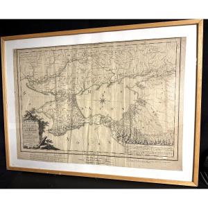
Large map of the government of Taurid, including Crimea and neighboring countries. Published by Dezauche in 1788 in Paris. Framed and under glass. Dimensions: 58.5 cm x 78.5 cm (framed). 47.5 cm x 67.[...]
Epreuve originale réalisée en 1720. Guillaume de Lisle cartographe.Beaux coloris anciens.2 petites déchirures sur 1cm dans les marges supérieures et inférieures du pli central restaurées anciennement.[...]
Epreuve originale réalisée en 1762. Jean Janvier cartographe.Limites colorées de l’époque.Très bon état.Format feuille : 51 x 38,5 cm.Format gravure : 46 x 32 cm.Original antique map of 1762.Echelle d[...]
Rare map of Brittany by Joannis Montecalerio, Milan 1712, "Choraphica descriptio Provincianum et Conventium Fratrum Minorum S Francisci Capucinorum". Beautiful colors and decorations of towns, a ship,[...]
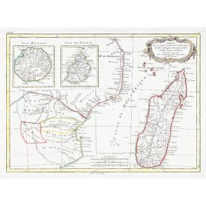
18th-century watercolor map of Bourbon Island, Réunion Island, circa 1750, by Bellin. Beautiful original colors from a Dutch edition with text in French and Dutch. Pitch pine frame with fillet, 35 cm [...]
Antonio Sandi(Puos d’Alpago, 1733 – 1817)The Ancient and Modern Venetian Lagoon, newly delineated and distinguished in its islands, valleys, and canals as they are todayCopper engraving, 47 x 64.5 cmS[...]
Epreuve originale réalisée en 1771. Rigobert Bonne géographe.Une signature manuscrite dans l’angle droit de la marge supérieure, loin de la carte.Limites colorées de l’époque.Très bon état.Format feui[...]
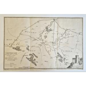
[NORMANDY]. BLONDEAU, Alexandre Jean Nicolas. Detailed map of the main roads around Falaise and Guibray, [Paris: ca. 1800]. Copper engraving. Sheet dimensions: 42 x 28 cm. Two contemporary handwritten[...]
Original print made in 1787. Author: Philippe de Pretot. Beautiful watercolor coloring. Very good condition. Sheet size: 50.5 x 33.5 cm. Image size: 44.5 x 30.5 cm. Original antique map of 1787. You c[...]
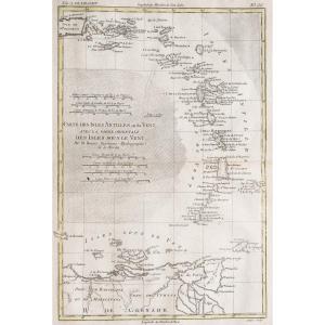
7 épreuves originales réalisées en 1775. Rigobert Bonne Auteur.Limites colorées de l’époque.Fines rousseurs claires dans les marges et traces de trous de ver rebouchées dans le bas des cartes de l’Amé[...]
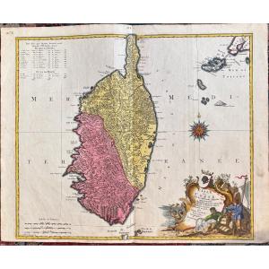
Lotter Tobias Conrad The island of Corsica with its various districts, belonging to the Republic of Genoa, but divided and in revolt for several years. Augsburg around 1740 49.5 X 57.5cm
Epreuve originale réalisée vers 1764. Roux graveur.Quelques rousseurs dans la marge inférieure.Bon état.Format feuille : 23 x 17 cm.Format gravure : 20,5 x 14 cm.Original antique engraving around 1764[...]
Plan de la ville et citadelle d’Anvers.Epreuve originale réalisée en 1711. Henri Fricz auteur.Belle impression bien contrastée.Très bon état.Format feuille : 58 x 42 cm.Format gravure : 53,5 x 39,5 cm[...]
Epreuve originale réalisée en 1705. Nicolas de Fer géographe.Rousseurs dans les marges n’atteignant pas le plan.Bon état.Format feuille : 42,5 x 30,5 cm.Format gravure : 39 x 28,5 cm.Original antique [...]
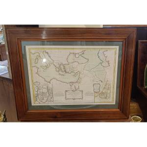
18th century watercolor map by Rigobert Bonne titled "Map of the Regions and Places spoken of in the New Testament" representing the entire Mediterranean basin at the time of the Gospels. Representati[...]
Epreuve originale réalisée en 1811. Chardin Jean auteur.Auréole et rousseur dans l’angle inférieur droit.Etat correct.Format feuille : 50 x 33,5 cm.Format gravure : 40 x 24 cm.Original antique engravi[...]
Epreuve originale réalisée en 1705. Nicolas De Fer cartographe.Rousseurs claires dans la marge latérale gauche.Bon état.Format feuille : 40 x 28 cm.Original antique map of 1705.Ile, rocher, ville, châ[...]
Epreuve originale réalisée en 1793. Faden éditeur.Beaux coloris aquarelle.2 mouillures dans la marge supérieure n’atteignant pas la carte.Très bon état.Format feuille : 37 x 27 cm.Format gravure : 35 [...]
Epreuve originale réalisée en 1728. Homann cartographe.Beaux coloris aquarelle.Fine oxydation dans le pli central.Très bon état.Format feuille : 63,5 x 53 cm.Format gravure : 58 x 49,5 cm.Original ant[...]
Nouvelle carte géographique des postes et autres routes d’Allemagne, poussées jusque dans les Pays-Bas, en Suisse, en Italie, en Hongrie, en Pologne, en Prusse, au Danemark…Grande épreuve originale gr[...]
Belle épreuve sur grand papier réalisée vers 1750. Bellin cartographe.Coloris aquarelle.Très bon état.Format feuille : 48,5 x 33,5 cm.Format gravure : 23 x 18 cm.Original antique map around 1750Vous p[...]
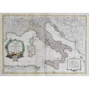
Carte d’Italie, assujettie aux observations astronomiques et aux itinéraires comprenant toutes les grandes routes qui traversent les différents états de cette région, avec les distances par postes.Gra[...]
Very beautiful map of Europe engraved in 1754 by Jean-Baptiste d'ANVILLE (1697-1782). These are 2 plates engraved with etching and enhanced with watercolor measuring 51 x 83 cm (copper) and 55.5 x 84 [...]
Very beautiful map from 1763 showing the "Known World of the Ancients" ("Orbis veteribus notus") by Jean-Baptiste d'ANVILLE (1697-1782). It is an etching enhanced with watercolor measuring 54.5 x 77.5[...]
Very beautiful map showing a view of the EUPHRATES and the TIGER in 1779 by Jean-Baptiste d'ANVILLE (1697-1782). It is an etching enhanced with watercolor measuring 44.5 x 53 cm (copper) and 51.5 x 68[...]
Very beautiful etching by Jean-Baptiste d'ANVILLE (1697-1782) depicting a view of Egypt and Saudi Arabia in 1765. The work measures 69 x 41.5 cm (copper) and 72.5 x 56.5 cm (sheet). Free delivery in P[...]
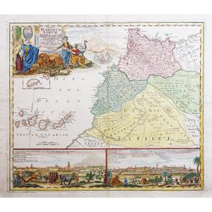
Very beautiful map of Africa engraved by Jean-Baptiste d'ANVILLE (1697-1782) in 1772. It is an etching enhanced with watercolor measuring 53.5 x 124 cm (copper) and 55 x 127 cm (sheet). Free delivery [...]
Epreuve originale réalisée en 1705. Nicolas De Fer cartographe.Limites colorées de l’époque.1 pincement de papier ancien dans le cartouche de titre.Débord d’encre dans les légendes autour de la ville [...]
Épreuve originale réalisée vers 1710 chez Pierre Mortier à Amsterdam. Nicolas de Fer cartographe.Rousseurs claires dans les marges.Coloris aquarelle.Très bon état.Format feuille : 33,5 x 27,5 cm.Forma[...]
Epreuve originale réalisée vers 1770. Lotter cartographe.Beaux coloris anciens.Rousseurs et renforts au dos des marges latérales n’atteignant pas la carteBon état.Format feuille : 65,5 x 53,5 cm.Forma[...]
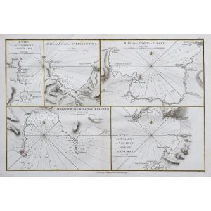
Giovanni Valle was a Venetian engraver and cartographer active in the late 18th and early 19th century. He is mainly known for his geographical engravings and maps that contributed to the great cartog[...]
This map is old, it was framed in the 60s with protective glass. We note that the map is stained in places, traces of wear on the small golden element which fixes the tile. Our numerous photos allow y[...]
Original proof made around 1790. Delamarche cartographer. Beautiful watercolor colors. A light foxing in the lower margin far from the map. Very good condition. Sheet size: 77 x 59 cm. Engraving size:[...]
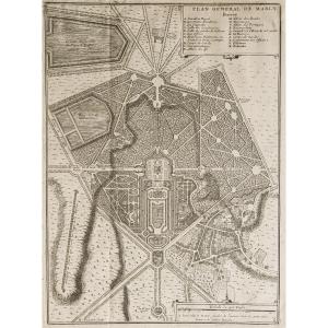
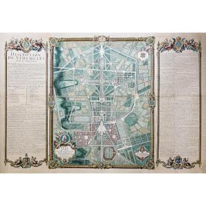
https://cartes-livres-anciens.com/produit/cartes-geographiques-anciennes-original-antique-maps/france/ile-de-france-78-versailles/plan-monumental-de-versailles-ville-et-chateau/Original plan from 1717[...]
Epreuve originale réalisée vers 1780. Denis et Patour éditeur.Fines traces de plis dans l’encadrement.Beaux coloris anciens.Bon état.Format feuille : 68 x 46 cm.Original antique map of 1780.Grande car[...]
Carte ancienne gouvernement du DauphinéEpreuve originale réalisée vers 1710. De Witt cartographe.Limites colorées de l’époque.Très bon état.Format feuille : 62,5 x 53,5 cm.Format gravure : 60,5 x 50 c[...]
This color map is from the 18th century. It was framed under glass in the 1960s. It is in generally acceptable condition, but not perfect, with some foxing. Our photos allow you to appreciate the qual[...]
Les élections de Tours, d’Amboise, de Loches, de Richelieu, de Chinon, de Bauge, de Montreuil Bellay et d’Angers, dans la généralité de Tours.Epreuve originale réalisée en 1711. Jaillot cartographe.Li[...]
Rare historical document: Handwritten letter signed in 1786 by José Moñino y Redondo, better known as the Count of Floridablanca, a prominent 18th-century Spanish political figure and Minister of Stat[...]
Carte géographique ancienne de la Perse – Iran Grande épreuve originale en seconde édition de 1785 par Dezauche.Limites colorées de l’époque.Très bon état.Format feuille : 82 x 57,5 cm.Format gravure[...]
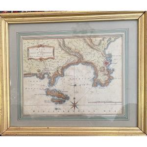
A significant historical episode of the city of Toulon, the 1707 siege took place in the context of England’s territorial expansion during the War of the Spanish Succession.Our map, has for legend : “[...]
Epreuve originale réalisée en 1771. Desnos géographe.Rousseurs claires dans les textes explicatifs.Bon état.Format feuille : 55,5 x 40 cm.Original antique map of 1771.Gouvernements d’Orléanois, de Tou[...]
Epreuve originale réalisée en 1787. Philippe de Pretot auteur.Beaux coloris aquarelle.Très bon état.Format feuille : 50,5 x 33 cm.Format gravure : 40 x 28 cm.Original antique map of 1787.Carte chorogr[...]
Epreuve originale réalisée au 18e siècle. D’après Merian auteur.Impression bien contrastée.2 plis anciens.Bon état.Format feuille : 16 x 13 cm.Format gravure : 15 x 11,5 cm.Petit plan de la ville de L[...]
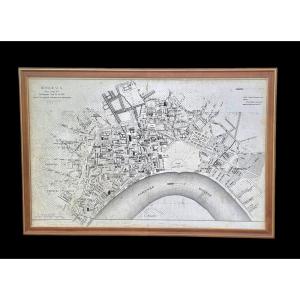
Old and very interesting map of the city of Bordeaux and its suburbs in 1775, under King Louis XVI after the major works of the intendants. Very detailed map, locating the main streets, avenues, squar[...]
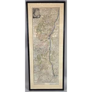
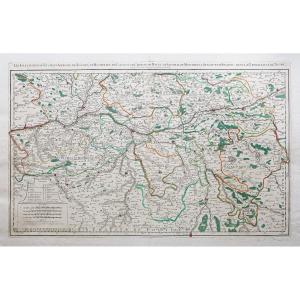
“Tabula Delphinatus et vicinarum regionnum” by Guillaume de L’Isle (Paris 1675-Paris1726). Copper engraving. In Amsterdam Covens and Mortier. Early 18th century. Sheet
54.5 x 65 cm
Proantic uses a cookie to analyze traffic and improve its service by using Google Analytics. Data sent to Google Analytics (frequency of visits to the site and pages visited) are anonymous. No other cookie tracks your activity, your personal data is not collected. Thank you for helping us to have better understanding how Proantic is used.


 Le Magazine de PROANTIC
 TRÉSORS Magazine
 Rivista Artiquariato