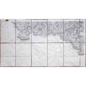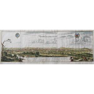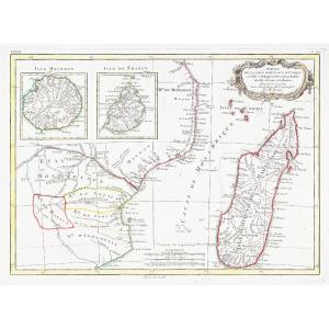

Old Map Of Madagascar – Réunion – Mauritius
Epreuve originale réalisée en 1771. Rigobert Bonne géographe.
Une signature manuscrite dans l’angle droit de la marge supérieure, loin de la carte.
Limites colorées de l’époque.
Très bon état.
Format feuille : 51,7 x 38,5 cm.
Format gravure : 42,7 x 31 cm.
Original antique map of 1771.
Echelle des lieux. Cartouche de titre décoratif. Supplément de l’île Bourbon et de l’île Maurice.
Vous pouvez consulter l’ensemble des cartes, livres et gravures disponibles sur votre région en cliquant sur le lien de notre site internet spécialisé en archives anciennes géographiques :
https://cartes-livres-anciens.com/categorie-produit/cartes-geographiques-anciennes-original-antique-maps/france/dom-tom/
Règlement sécurisé par carte bancaire sur notre site internet en cliquant sur le lien ci-dessous :
https://cartes-livres-anciens.com/produit/cartes-geographiques-anciennes-original-antique-maps/afrique/madagascar/carte-ancienne-de-madagascar-reunion-maurice/
Toutes nos cartes et gravures sont accompagnées d’un certificat d’authenticité.
Rigobert Bonne(1727-1795) est un ingénieur hydrographe et cartographe français du 18ème siècle.
Né dans les Ardennes à Raucourt en 1727, il succède en 1775 à Giovanni Rizzi-Zannoni comme cartographe du Roi de France au Service Hydrographique de la Marine (le Dépôt des cartes et plans de la Marine est créé sur ordre du Roi Louis XV en 1720).
Vers 1780, il définit précisément la projection qui portera alors son nom : la Projection de Bonne.
Il meurt à Paris en 1795, son fils Charles-Marie Rigobert dit le Chevalier Bonne (25 juin 1771 – 23 novembre 1839), poursuivra son œuvre.
Original map made in 1771. Rigobert Bonne, geographer. A handwritten signature in the upper right-hand margin, away from the map. Contemporary colored borders. Very good condition. Sheet size: 51.7 x 38.5 cm. Image size: 42.7 x 31 cm. Original antique map of 1771. Scale of locations. Decorative title cartouche. Supplement for Bourbon Island and Mauritius. You can view all the maps, books, and engravings available for your region by clicking on the link to our website specializing in antique geographical archives: https://cartes-livres-anciens.com/categorie-produit/cartes-geographiques-anciennes-original-antique-maps/france/dom-tom/ Secure payment by credit card on our website by clicking on the link below: https://cartes-livres-anciens.com/produit/cartes-geographiques-anciennes-original-antique-maps/afrique/madagascar/carte-ancienne-de-madagascar-reunion-maurice/ All our maps and engravings come with a certificate of authenticity. Rigobert Bonne (1727-1795) was an 18th-century French hydrographic engineer and cartographer. Born in Raucourt in the Ardennes in 1727, he succeeded in 1775 to Giovanni Rizzi-Zannoni as cartographer to the King of France at the Hydrographic Service of the Navy (the Depot of Maps and Plans of the Navy was created on the order of King Louis XV in 1720). Around 1780, he precisely defined the projection which would then bear his name: the Bonne Projection. He died in Paris in 1795, his son Charles-Marie Rigobert known as the Chevalier Bonne (June 25, 1771 – November 23, 1839), continued his work.
430 €
Period: 18th century
Style: Other Style
Condition: Excellent condition
Material: Paper
Reference (ID): 1665845
Availability: In stock
Print