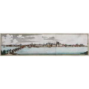
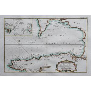
Nautical Chart Of Saint-jean-cap-ferrat
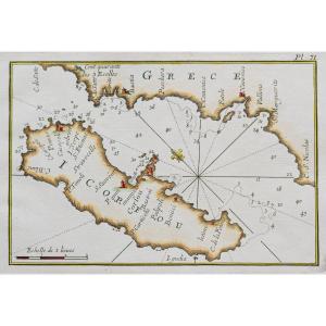
Epreuve originale réalisée vers 1764. Roux graveur.
Quelques rousseurs dans la marge inférieure.
Bon état.
Format feuille : 23 x 17 cm.
Format gravure : 20,5 x 14 cm.
Original antique engraving around 1764.
Epreuve illustrant Ville Franche et Saint-Jean-Cap-Ferrat.
Echelle de toises. Boussole. Relevés des fonds marins.
Vous pouvez consulter l’ensemble des cartes, livres et gravures disponibles sur votre région en cliquant sur le lien de notre site internet spécialisé en archives anciennes géographiques :
https://cartes-livres-anciens.com/categorie-produit/cartes-geographiques-anciennes-original-antique-maps/france/provence-cote-dazur/
Règlement sécurisé par carte bancaire sur notre site internet en cliquant sur le lien ci-dessous :
https://cartes-livres-anciens.com/produit/cartes-geographiques-anciennes-original-antique-maps/france/provence-cote-dazur/carte-marine-de-saint-jean-cap-ferrat/
Toutes nos cartes et gravures sont accompagnées d’un certificat d’authenticité.
Joseph Roux(1725-1793) était un hydrographe marseillais. Editeur et cartographe, il publia des cartes, des instruments de navigation et des équipements nautiques.
Vers le milieu du siècle, il reçut le titre « d’Hydrographe du Roy » et publia en 1764 une série de cartes de la Méditerranée. Il publia simultanément une collection de plus petit format de cartes marines.
Original proof made around 1764. Roux engraver. Some foxing in the lower margin. Good condition. Sheet size: 23 x 17 cm. Engraving size: 20.5 x 14 cm. Original antique engraving around 1764. Proof illustrating Ville Franche and Saint-Jean-Cap-Ferrat. Toise scale. Compass. Seabed surveys. You can consult all the maps, books and engravings available in your region by clicking on the link to our website specializing in old geographical archives: https://cartes-livres-anciens.com/categorie-produit/cartes-geographiques-anciennes-original-antique-maps/france/provence-cote-dazur/Secure payment by credit card on our website by clicking on the link below: https://cartes-livres-anciens.com/produit/cartes-geographiques-anciennes-original-antique-maps/france/provence-cote-dazur/carte-marine-de-saint-jean-cap-ferrat/All our maps and engravings are accompanied by a certificate of authenticity. Joseph Roux (1725-1793) was a hydrographer from Marseille. A publisher and cartographer, he published maps, navigational instruments, and nautical equipment. Around the middle of the century, he received the title of "Hydrographer to the King" and published a series of maps of the Mediterranean in 1764. He simultaneously published a smaller collection of nautical charts.
120 €
Period: 18th century
Style: Other Style
Condition: Good condition
Material: Paper
Reference (ID): 1629758
Availability: In stock
Print