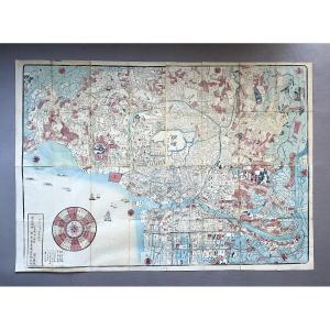
Large map of Tokyo. Printed in ink and color on paper, depicting the capital and its surroundings, oriented west, dated Meiji 3 (1870). Light stains, small tears along the folds. 69.5 x 99 cm. Shipped[...]
Epreuve originale réalisée en 1758. T. Jefferys Auteur.Beaux coloris aquarelle.Très bon état.Format feuille : 29 x 23,5 cm.Format gravure : 26 x 20 cm.Original antique plan of 1758.Cartouche de titre [...]
"Illustrated Map of Picturesque Views, Costumes and Coats of Arms of the Principal Provinces of France." "Drawn from the Post House Map and the most recent works of the Bridges and Roads Department, s[...]
Epreuve originale réalisée en 1827.Vandermaelen éditeur.Limites colorées de l’époque.Très bon état.Format feuille : 70 x 53 cm.Original antique engraving of 1827Echelle des lieux. Peu courant.Vous pou[...]
a set of four maps two maps of the Haut Rhin and two maps of Moselle a map of the Haut-Rhin department engraved by Barty and published in Paris by Combette in 1845 measuring 35x53 cm another map of th[...]
Carte originale gravée en 1870. Johnston cartographe.Belle impression en couleurs.Très bon état.Format feuille : 61,5 x 47,5 cm.Original antique map of 1870Vous pouvez consulter l’ensemble
des cartes[...]
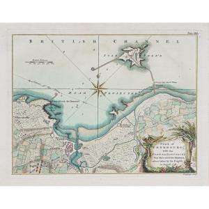
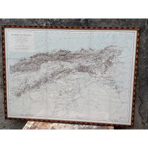
Original proof engraved in 1843. De Laroche Poncié hydrographe. Reinforcement on the back of the central fold in the left side margin. Fine oxidation in the center of the proof. Very nice impression. [...]
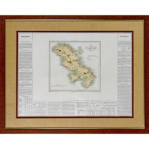
A VERY BEAUTIFUL and LARGE MAP OF MARTINIQUE, with a clear and legible map in the center, surrounded by economic, administrative, and historical information intended for an informed general public.Cen[...]
This 19th century map was framed in the 20th century. We note stains and folds on the map. Our photos allow you to appreciate the quality of this map. For the condition, please detail the photos. Do n[...]
Epreuve originale réalisée en 1890.Impression en couleurs.Rousseurs claires éparses.Bon état.Format feuille : 65 x 49 cm.Original antique chart of 1890.Rare collection illustrant les ports de France.I[...]
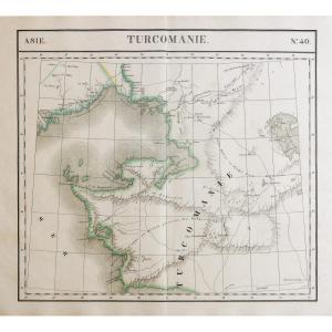
Petite carte d’Orient et de la Méditerranée.Epreuve originale réalisée en 1840. Ch. Avril graveur et Simon lithographe.Limites colorées de l’époque.Très bon état.Format feuille : 43,5 x 27,5 cm.Origin[...]
Epreuve originale réalisée vers 1820. Benedetto Bordiga auteur.Infime manque de papier dans l’angle inférieur droit.Fines rousseurs claires au-dessus du Mont Blanc.2 renforts sur 1 cm au dos de la pre[...]
This color engraving is old. It was framed under glass in the 1960s. We note some foxing on the engraving and various small stains. The engraving remains, however, in acceptable but not perfect condit[...]
Original folding map mounted on linenRare and highly detailed folding map of London published by George Frederick Cruchley, titled Cruchley’s New Plan of London, in the edition “Improved to 1st Januar[...]
Epreuve originale réalisée en 1898. Labouche frères éditeurs.Première édition.Impression en couleurs.1 rousseur dans la rue de la Chaine.Très bon état.Format feuille : 59 x 48,5 cm.Format replié : 13,[...]
Grand plan original réalisé en 1860.Entoilé d’époque et monté en 32 sections.Rousseurs claires éparses.Bon état.Format feuille : 111,5 x 94 cm.Format repliée : 24 x 14 cm.Original antique map of 1860.[...]
Epreuve originale réalisée en 1899. Lecocq graveur.Impression en couleurs.Très bon état.Format feuille : 39 x 29 cm.Original antique map of 1899.Edition de la fin du 19ème siècle agrémentée d’un carto[...]
Grande épreuve originale réalisée en 1873.Impression en couleurs.Rousseurs claires dans les marges.Bon état.Format feuille : 95,5 x 66,5 cm.Original antique chart of 1873.Rare collection illustrant le[...]
Large map of Gaul under the Romans produced in 1820 by Brué, Adrien-Hubert (1786-1832) to be used for reading the History of France before the establishment of the monarchy Desray bookseller publisher[...]
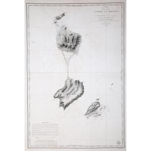
Situé à la partie septentrionale de l’ile de CorseEpreuve originale réalisée en 1851. Gauttier Duparc lithographe.Coloris aquarelle.Très bon état.Format feuille : 29 x 21 cm.Original antique chart of [...]
Carte gravée en 1895. L.Smith graveur.Coloris aquarelle.Bon état.Format : 52,5 x 39,5 cm.Original antique map of 1895.Edition de la fin du 19ème siècle, impression en couleurs. Cartouche aquarellé ill[...]
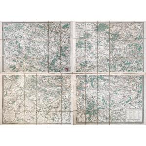
4 Plans entoilés d’époque montés en 18 sections.Coloris aquarelle.Emboitage avec traces de frottements, couvercle fendu.Très bon état.Format de chaque plan : 71 x 50,5 cm.Format assemblé : 145 x 105 c[...]
Carte gravée en 1894.Belle impression en couleurs.Très bon état.Format feuille : 67 x 49 cm.Original antique chart of 1894.Rare collection illustrant les ports de France.Institution qui modèle le litt[...]
Epreuve originale réalisée fin 19e siècle. Chez Rignoux imprimeur.Beaux coloris aquarelle.Rousseurs dans les marges et dans la partie latérale droite.1 petite restauration d’une ancienne déchirure au [...]
Carte gravée en 1898.Belle impression en couleurs.Très bon état.Format feuille : 67 x 49 cm.Original antique chart of 1898.Rare collection illustrant les ports de France.Institution qui modèle le litt[...]
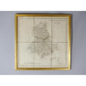
Framed map of the department of Haute Vienne 87 by AM Perrot and J Aupice printed in 1825 by the publisher Duprat Duverger. Originally folded map which was then flattened and framed. Gilded wooden fra[...]
Embroidered map representing the department of Drôme, made at the beginning of the 19th century. The composition follows a decorative grammar specific to this period, close to the ornaments visible on[...]
RAVENSTEIN (August) [Geographical Atlas for Primary Education] - 6 relief maps Set of 6 relief maps for educational use and for the visually impaired. The complete edition consisted of eight relief ma[...]
From the NEW GEOGRAPHY and STATISTICS of FRANCE. By J. HENRY. Each plate is presented in the same way: Famous person, presentation of the department, a part on the remarks and curiosities of the place[...]
Pretty little original polychrome engraving, representing the department of HAUT-RHIN with a small comment on the number of inhabitants, surface area… Hand-watercoloured. Dimension(s): Frame: Height. [...]
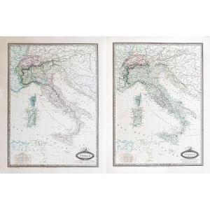
Antiquae and Novae map of Italy published in London in 1825. Entirely canvassed in two parts, North and South, this map is bilingual. The ancient places are associated with Italian names in order to g[...]
Carte originale gravée en 1880.
Très bon état.
Format feuille : 35 x 27 cm.
Format gravure : 26,5 x 21 cm.
Original antique plan of 1880.
Blasons décoratifs de Philippe Auguste, Hôtel Vauvert (Lu[...]
Tableau Sphéroïdal de la Terre ou Mappemonde en deux Hémisphères.
Grande épreuve originale réalisée en 1860. Garnier F.A cartographe.
Très belle impression en couleurs.
Infimes rousseurs.
Très bon[...]
Bouzigues, Balaruc-le-Vieux, Balaruc-les-bains.
Carte gravée en 1894.
Impression en couleurs.
Très bon état.
Format feuille : 66,5 x 49 cm.
Original antique chart of 1894.
Rare collection illust[...]
Epreuve originale réalisée en 1826.
Limites colorées de l’époque.
Excellent état
Format feuille : 51 x 41 cm.
Peu courante publication réalisée sous le règne de Charles X, illustrant les départem[...]
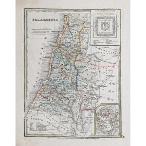
Epreuve originale réalisée en 1815. Charle auteur.
Quelques rousseurs claires.
Bon état.
Format feuille : 44 x 29 cm.
Vous pouvez consulter l’ensemble des cartes, livres et gravures disponibles [...]
Map made by the Geographer Victor Levasseur. Pélissier publisher, engraved by Smith and Burty in 1852 From the Atlas National Illustré between 1842 and 1872 This map shows the towns and villages of Av[...]
I offer you this beautiful card, dating from the middle of the 19th century, enhanced with watercolor and gouache, at the time. Pretty colors, a good mat, a lacquered baguette, all dated 1968 on the b[...]
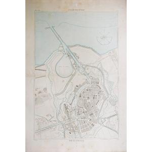
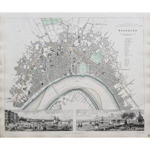
BORDEAUX – Map of the City of Bordeaux and its Suburbs Year XII, around 1803-1804 / sn Paris: at Jean. rue Jean de Bauvais Print on paper, black and white or color support: paper dimensions: 78 × 107 [...]
Epreuve originale réalisée en 1875.
Impression en couleurs.
Très bon état.
Format feuille : 65 x 49 cm.
Original antique chart of 1875.
Rare collection illustrant les ports de France.
Institutio[...]
Epreuve originale réalisée en 1810.
Très bon état.
Format feuille : 23 x 30 cm.
Encadrés avec renvois situant les monuments, places, édifices et rues du quartier.
Vous pouvez consulter l’ensembl[...]
Great map
"L'EMPIRE FRANÇAISE et de L'ALLEMAGNE"
dated 1810
It is in excellent condition, with visible signs of aging.
DIMENSIONS Map: Width 102 cm - Height 76 cm
DIMENSIONS Frame: Width 108[...]
Carte originale gravée en 1860.
Beaux coloris aquarelle.
Rousseurs claires.
Très bon état.
Format feuille : 53 x 36 cm.
Format gravure : 44 x 32 cm.
Original antique map of 1860.
Célèbre éditio[...]
Le dessin préparatoire de cette aquatinte à été réalisé lors du Voyage autour du monde à bord du navire La Favorite commandée par Cyrille Laplace en 1830 . Peu courant.
Laplace's journey. Aquatint en[...]
Epreuve originale réalisée en 1848. Editée à Edimbourg par Johnston.
Coloris aquarelle.
Mouillures claires et plis de papier ancien.
Bon état.
Format feuille : 68 x 55,5 cm.
Original antique map [...]
gravure de Lemercier tirée de l'atlas national français représentant le département français de l'Allier France milieru du XIX sec.
33 cm x 56 a encadrer
gravure de Lemercier tirée de l'atlas national français représentant le département français du Finistère France milieru du XIX sec.
33 cm x 56 a encadrer
Very beautiful map of Nice, The city and the castle, Watercolored, Work from the 18th/19th century. In very good condition, Weight: 1300 gr. Dimensions: Height: 34 cm, Width: 44 cm. At sight: Height: [...]
Italie, limites en 1859.
Italie, limites en 1861
2 épreuves originales réalisées en 1861. Garnier F.A cartographe.
Très belle impression en couleurs.
Infimes rousseurs.
Très bon état.
Formats fe[...]
Lithographie originale de 1870. Benoist dessinateur et lithographe.
Belle impression en couleurs.
Fines rousseurs du temps.
Très bon état.
Format feuille : 46 x 31 cm.
Vous pouvez consulter l’e[...]
Epreuve originale réalisée en 1832. J. Henshall graveur et Clarke dessinateur.
Fine consolidation dans la marge latérale droite n’atteignant pas la carte.
Bon état.
Format feuille : 41 x 34,5 cm.
[...]
Drawn and handwritten map from 1823 of the Kingdom of France (under the reign of Charles X). Very beautiful work of cartography signed and dated, recent framing.
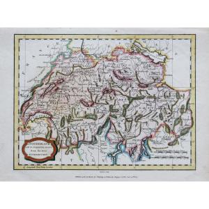
Switzerland with its subjects and allies from the best authorities.
Epreuve originale réalisée en 1807. J. Barlow graveur.
Coloris anciens.
2 rousseurs claires dans la marge supérieure n’atteignant[...]
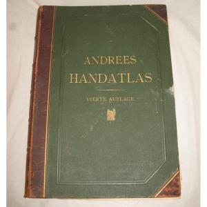
Handatlas de Andrees Collection of maps in German language dated 1899 Comprising 126 maps in plano and 137 side maps 4th edition by A. Scobel in Leipzig Drawing board type binding in strong cardboard [...]
Proantic uses a cookie to analyze traffic and improve its service by using Google Analytics. Data sent to Google Analytics (frequency of visits to the site and pages visited) are anonymous. No other cookie tracks your activity, your personal data is not collected. Thank you for helping us to have better understanding how Proantic is used.


 Le Magazine de PROANTIC
 TRÉSORS Magazine
 Rivista Artiquariato