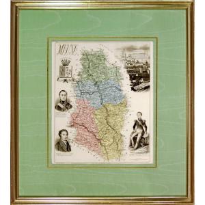
Framed Map Of Aveyron: Geographer Levasseur Published By Pélissier 1852
Artist: Victor Levasseur. Pélissier éditeur, Gravé Par Smith Et Burty
Map made by the Geographer Victor Levasseur. Pélissier publisher, engraved by Smith and Burty in 1852 From the Atlas National Illustré between 1842 and 1872 This map shows the towns and villages of Aveyron at the time with the layout of all the roads, railways and canals. But also illustrations representing specialities, statistical, historical and economic information. With the portraits of: on the right Jean de Pomairols (1592-1656) Lord of Gramond and La Pèze, President of the Presidial of Villefranche and Criminal Judge at the Seneschal of Rouergue, in Villefranche. And on the left Charles-Louis-Auguste Fouquet de Belle-Isle, (1684-1761), grandson of the superintendent of finances of Louis XIV, Nicolas Fouquet, French officer and diplomat, Marshal of France in 1740. (Thanks Wikipedia)
Dimension is 58 X 44 cm for the frame, old frame, molded baguette and approximately 50 x 36 cm for the engraving.
Some dirt under the glass (never unframed)
Dimension is 58 X 44 cm for the frame, old frame, molded baguette and approximately 50 x 36 cm for the engraving.
Some dirt under the glass (never unframed)
80 €
Period: 19th century
Style: Napoleon 3rd
Condition: Good condition
Material: Paper
Width: 58 cm
Height: 44 cm
Reference (ID): 1451440
Availability: In stock
Print