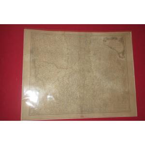
Old Geographic Map Of The United States
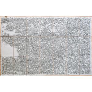
Epreuve originale réalisée en 1860. Garnier F.A cartographe.
Très belle impression en couleurs.
Infimes rousseurs.
Très bon état.
Format feuille : 61 x 42,5 cm.
Format gravure : 49 x 37 cm.
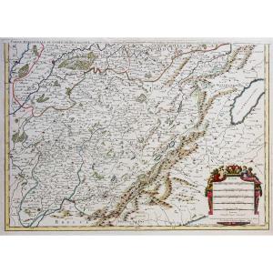
Original antique map of 1860.
Carte illustrée d’un cartouche de St. Pierre et Miquelon. Echelle des mesures.
Nouvelle géographie réalisée par le cartographe L.A Garnier en 1860, membre de la société de Géographie depuis 1850.
La parfaite netteté des coloris, le choix du papier et l’exécution typographique furent unanimement salués par la communauté scientifique de l’époque. Peu courant.
Vous pouvez consulter l’ensemble des cartes, livres et gravures disponibles sur votre région en cliquant sur le lien de notre site internet spécialisé en archives anciennes géographiques :
https://cartes-livres-anciens.com/categorie-produit/cartes-geographiques-anciennes-original-antique-maps/ameriques/etats-unis/
Règlement sécurisé par carte bancaire sur notre site internet en cliquant sur le lien ci-dessous :
https://cartes-livres-anciens.com/produit/cartes-geographiques-anciennes-original-antique-maps/ameriques/etats-unis/carte-geographique-ancienne-des-etats-unis-2/
Toutes nos cartes et gravures sont accompagnées d’un certificat d’authenticité.
Original proof made in 1860. Garnier FA cartographer. Very beautiful color print. Minor foxing. Very good condition. Sheet size: 61 x 42.5 cm. Engraving size: 49 x 37 cm. Original antique map of 1860. Map illustrated with a cartouche of St. Pierre and Miquelon. Scale of measurements. New geography produced by the cartographer LA Garnier in 1860, member of the Geographical Society since 1850. The perfect clarity of the colors, the choice of paper and the typographic execution were unanimously praised by the scientific community of the time. Uncommon. You can view all the maps, books and engravings available in your region by clicking on the link to our website specializing in old geographical archives: https://cartes-livres-anciens.com/categorie-produit/cartes-geographiques-anciennes-original-antique-maps/ameriques/etats-unis/Secure payment by credit card on our website by clicking on the link below: https://cartes-livres-anciens.com/produit/cartes-geographiques-anciennes-original-antique-maps/ameriques/etats-unis/carte-geographique-ancienne-des-etats-unis-2/All our maps and engravings are accompanied by a certificate of authenticity.
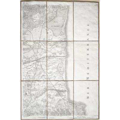
Très belle impression en couleurs.
Infimes rousseurs.
Très bon état.
Format feuille : 61 x 42,5 cm.
Format gravure : 49 x 37 cm.
Original antique map of 1860.
Carte illustrée d’un cartouche de St. Pierre et Miquelon. Echelle des mesures.
Nouvelle géographie réalisée par le cartographe L.A Garnier en 1860, membre de la société de Géographie depuis 1850.
La parfaite netteté des coloris, le choix du papier et l’exécution typographique furent unanimement salués par la communauté scientifique de l’époque. Peu courant.
Vous pouvez consulter l’ensemble des cartes, livres et gravures disponibles sur votre région en cliquant sur le lien de notre site internet spécialisé en archives anciennes géographiques :
https://cartes-livres-anciens.com/categorie-produit/cartes-geographiques-anciennes-original-antique-maps/ameriques/etats-unis/
Règlement sécurisé par carte bancaire sur notre site internet en cliquant sur le lien ci-dessous :
https://cartes-livres-anciens.com/produit/cartes-geographiques-anciennes-original-antique-maps/ameriques/etats-unis/carte-geographique-ancienne-des-etats-unis-2/
Toutes nos cartes et gravures sont accompagnées d’un certificat d’authenticité.
Original proof made in 1860. Garnier FA cartographer. Very beautiful color print. Minor foxing. Very good condition. Sheet size: 61 x 42.5 cm. Engraving size: 49 x 37 cm. Original antique map of 1860. Map illustrated with a cartouche of St. Pierre and Miquelon. Scale of measurements. New geography produced by the cartographer LA Garnier in 1860, member of the Geographical Society since 1850. The perfect clarity of the colors, the choice of paper and the typographic execution were unanimously praised by the scientific community of the time. Uncommon. You can view all the maps, books and engravings available in your region by clicking on the link to our website specializing in old geographical archives: https://cartes-livres-anciens.com/categorie-produit/cartes-geographiques-anciennes-original-antique-maps/ameriques/etats-unis/Secure payment by credit card on our website by clicking on the link below: https://cartes-livres-anciens.com/produit/cartes-geographiques-anciennes-original-antique-maps/ameriques/etats-unis/carte-geographique-ancienne-des-etats-unis-2/All our maps and engravings are accompanied by a certificate of authenticity.
375 €
Period: 19th century
Style: Other Style
Condition: Excellent condition
Material: Paper
Reference (ID): 1529403
Availability: In stock
Print