This antique map was framed in the 1960s. You will notice creases, marks, and yellowing. However, the map remains presentable, though not perfect. Our photos allow you to appreciate the quality of the[...]
Depuis la rivière de Bordeaux jusqu’à Saint Sébastien.Epreuve originale réalisée en 1693. Mortier Pierre et Romain de Hooghe éditeur.Très beaux coloris anciens de Van Santen avec rehauts d’or.Très bon[...]
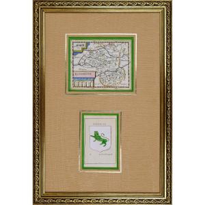
RARE MAP of MAINE (ANJOU / TOURAINE) accompanied by the COAT OF ARMS "Semé de France, à la bordure de Gueules, brisé au franc canton de pourpre au Lion d'Argent". By Pierre DU VAL D'ABBEVILLE, geograp[...]
Original steel engraving with a burin. Engraved by Tassin (Christophe), often mistakenly confused with Nicolas Tassin, he was in fact the King's engineer-geographer. Although his dates of birth and de[...]
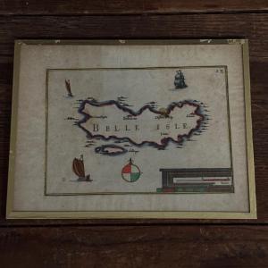
1634 map by Nicolas TASSIN of the Isle of Ré with various decorations: cartouche, 4 boats and compass rose. Beautiful 19th century frame in pitch pine with double fillets.
Grande épreuve originale réalisée vers 1690. Jaillot cartographe.Limites colorées de l’époque.Fines rousseurs claires dans les marges.Très bon état.Format feuille : 99,5 x 63,5 cmFormat gravure : 89,5[...]
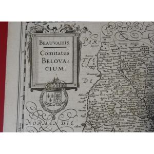
Magnificent old geographical map from the early 17th century. It represents a view of Beausaisis, the Beauvais region in Picardy. Period engraving by Jodocus Hondius (1593-1633). Good general conditio[...]
Rare and beautiful map circa 1679 of the bishopric of Luçon in Vendée, drawn up by Guillaume SANSON, son of Nicolas SANSON d'ABBEVILLE. It is decorated with three cartouches including a large title ca[...]
Original proof made around 1650. Jansson Johanne geographer. Antique colors. Explanatory text on the back in Spanish. Very good condition. Sheet size: 60 x 49.5 cm. Engraving size: 50 x 8.5 cm. Origin[...]
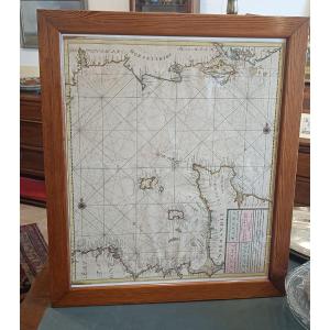
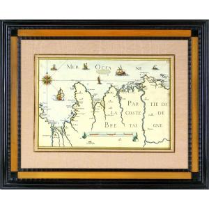
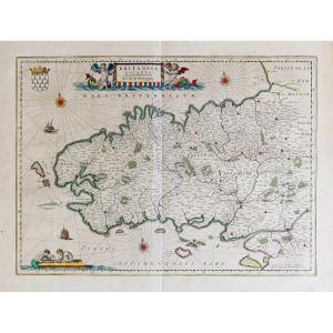
Large nautical chart "for the second part of the English Channel between England and France" circa 1680 by Van Keulen with: The French coasts of Normandy (Cotentin and Bessin) and northern Brittany (I[...]
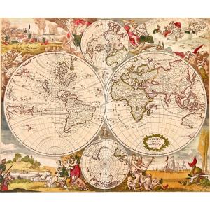
In Amsterdam in the late 1660s, Justus Danckerts created his first version of a decorative, double-page, double-hemisphere engraved world map, Nova Totius Terrarum Orbis Tabula. This finely colored ex[...]
Rare watercolor map of the island of Noirmoutier from 1634 by Christophe TASSIN. Beautiful old colors with Cartouche at the bottom right "Isle de Narmoustier" and many ships. Old walnut frame 31.5 cm [...]
Rare General Map of Poitou, Xaintonge, Angoulmois and the Aulnix region" by Christophe TASSIN from the 17th century around 1634. Map engraved on paper and watercolored from the period (foxing and fold[...]
Very beautiful map showing a view of ILLYRIA/DALMATIA by Nicolas SANSON (1600-1667). This is an etching enhanced with watercolor measuring 42 x 53 cm (copper) and 46 x 60.5 cm (sheet). Free delivery i[...]
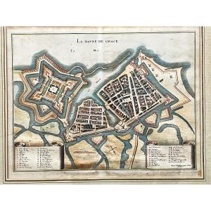
Rare 17th century print by Jacques Gomboust depicting the fortifications and port of Le Havre. In its original coloring. Taken from an atlas and therefore with an original fold in the middle of the ma[...]
Epreuve originale réalisée vers 1680. Cundier Louis Auteur.Fines traces de plis dans l’encadrement.Classiques renforts au dos de la marge inférieure.Bon état.Format feuille : 51 x 41,5cm.Orignal antiq[...]
Epreuve originale réalisée vers 1630. Johannes Jansson cartographe.Fines rousseurs dans la marge supérieure loin de la carte.Très beaux coloris anciensTexte explicatif au verso en vieux français.Très [...]
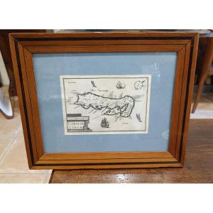
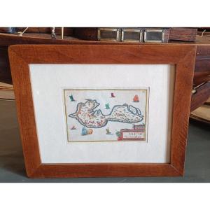
This color engraving is from the 17th century, it is authentic and old. It bears the inscription "Belle Isle" and the number 28 at the top right. It was framed under glass in the 1960s. You will notic[...]
Mercator color map of the County Carlow region in southeastern Ireland, with decorative cartouche at bottom left. Map engraved by Gerard MERCATOR, probably from the French edition of the atlas publish[...]
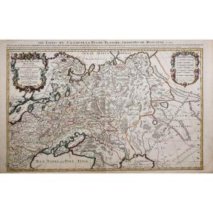
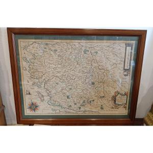
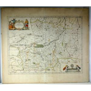
Beautiful colored engraving of Guyenne, one of the largest provinces of France under the Ancien Régime. It included various regions and provinces such as Périgord, Agenais, Quercy, and Rouergue. Very [...]
Gerardum Mercatorem Cum Privilegio. Map engraved by Gérard MERCATOR from the French edition of the atlas published by HONDIUS.Gerardi Mercatoris - The Atlas or Cosmographic Meditations of the Fabricat[...]
Geographical map BOHEMIA engraved by G MERCATOR between 1613 and 1616 (Czech Republic, Prague) map engraved by Gérard MERCATOR from the French edition of the atlas published by HONDIUS between 1613 an[...]
Original engraving paper from the time, framed, in excellent condition, size 53x42. . Decorative map of the Netherlands, published by Rossi in his Mercury geographical guide in all parts of the world [...]
RARE NAUTICAL CHART OF CANCALE TO THE POTERIEU ISLANDS - SAINT MALO BAY - POINTE SAINT CAST - HERQUY - SAINT BRIEUX - Ep. END OF THE 17TH CENTURY PART OF THE BRITTANY COAST - SAINT MALORARE BAY NAUTIC[...]
Watercolor map of Brittany by Tassin dating from 1634 with the towns, the islands of Groix, Belle Ile ... with decorations of cartouche, a compass rose and numerous boats. Very beautiful original colo[...]
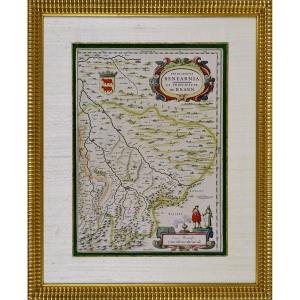
RARE MAP OF THE PRINCIPALITY OF BEARN (SOUTHWEST)Original intaglio engraving in period colors.It depicts the Principality of Béarn (Principatus Benearnia), a historical region located in the present-d[...]
Epreuve originale réalisée en 1632. Jean Leclerc éditeur.Rousseurs claires dans les marges.Texte en vieux Français au verso.Très bon état.Format feuille : 55 x 40 cm.Format gravure : 40,5 x 33 cm.Orig[...]
Engraving GOVERNMENT OF PROUINS (PROVINS - 77) RARE Burin engraving on steel, by Christophe TASSIN, born in the early 1600s and died in 1660, in France, also known as Nicolas Tassin, Christophe Nicola[...]
MAP AND GENERAL DESCRIPTION OF LANGUEDOC Drawn up by Jean Cavalier d'Agde, geographer to the king in 1621. In 1627, while he was 1st Consul of Agde, he married Dame d'Estienne at Notre-Dame du Grau. I[...]
Epreuve originale réalisée en 1630. Mercator/ Hondius cartographes.
Texte explicatif en latin au verso.
Beaux coloris anciens.
Fines rousseurs dans les marges.
Très bon état.
Format feuille : 57,[...]
Epreuve originale réalisée vers 1640. Jansson éditeur.
Beaux coloris anciens.
Texte explicatif en gothique au verso.
Renfort ancien au dos du pli central dans la marge inférieure.
Bon état.
Forma[...]
Plan of Montauban Attack by Louis 13 in 1621 The siege of Montauban pitted, from August to November 1621, the royal armies commanded by the King of France Louis XIII against the Protestants of Montaub[...]
MERIAN Matthäus (1593-1650) after Plan of La Rochelle (state of the city before the siege of 1628) Copper engraving Plate size: 10 x 14 cm Frame size: 27 x 30 cm tiny chip in the glass at the bottom l[...]
Epreuve originale réalisée en 1694. Merian graveur.
2 mouillures anciennes dans la marge supérieure loin du sujet.
Bon état.
Format feuille : 38 x 33,5 cm.
Format gravure : 34 x 22,5 cm.
Original[...]
Diocèse de Reims et le pays de Rethel.
Epreuve originale réalisée en 1645. Blaeu Guilem cartographe.
Texte explicatif en vieux français au verso.
Beaux coloris aquarelle.
Greffe de papier ancien s[...]
Epreuve originale réalisée en 1694. De Witt cartographe.
Belle épreuve bien contrastée.
Très bon état.
Format feuille : 62 x 43,5 cm.
Format gravure : 53,5 x 43,5 cm.
Original antique map of 1694[...]
Épreuve originale réalisée vers 1660. Duval cartographe.
Coloris aquarelle.
Texte en vieux français au verso.
Très bon état.
Format feuille : 57,5 x 42,5 cm.
Format gravure : 48,5 x 37,5 cm.
Ori[...]
Large engraved and watercolored map from the 17th century Lodun & Mirebalais (86)
Enhanced with watercolors in very fresh colors LA VIENNE. LOUDUN. (86) MIREBEAU (86) «LOUDONOIS. Laudunum.» (Loudun, [...]
17th century watercolor map of Tassin representing Belle Ile in a beautiful 19th century frame with fillet 28 cm x 22.3 cm Representation with compass rose and boats
Epreuve originale réalisée en 1690. Nicolas de Fer éditeur.
Beaux coloris aquarelle.
Très bon état.
Format feuille : 35 x 24,5 cm.
Original antique map of 1690.
Carte particulièrement décorative [...]
A rare color geographical map depicting the Papal State and the Grand Duchy of Tuscany, the work of Cornelius II Danckerts, dating back to around the end of the 17th century. It bears the Latin inscri[...]
Epreuve originale réalisée vers 1630.
Légende en latin et allemand.
Bon état.
Format feuille : 18,5 x 15 cm.
Format gravure : 14,5 x 10 cm.
Original antique engraving around 1630
Vous pouvez c[...]
1635 beautiful map of Geneva (Switzerland) Well colored map We can clearly see the watermark of the mill on the paper by transparency It is a castle located exactly at the level of the church to the r[...]
Epreuve originale réalisée vers 1640. Blaeu cartographe.
Beaux coloris anciens.
Texte explicatif en vieux français au verso.
Plusieurs villes ont été soulignées anciennement à l’encre noire.
Mouil[...]
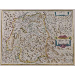
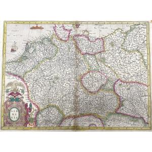
Grande épreuve originale réalisée en 1697. Joan Blaeu cartographe.
Beaux coloris aquarelle.
Classiques petites consolidations au dos des marges n’atteignant pas la carte.
Très bon état.
Format feu[...]
Very beautiful old map, Mercator, of Aquitaine and its neighboring regions, In used condition, it should be noted that the map has yellowed over time, See photos, Wooden frame and gilded and green stu[...]
Original proof made in 1627. Johannes Jansson cartographer. Explanatory text in Latin on the back. Beautiful old colors. Very good state. Sheet size: 56.5 x 44 cm. Engraving format: 50.5 x 39.5 cm. Or[...]
Giovanni Antonio Magini (en latin, Maginus) (Padoue, 13 juin 1555 – Bologne, 11 février 1617) était un astronome, un astrologue, un cartographe, un mathématicien et un universitaire italien.
Magini a[...]
RARE Chisel engraving on steel, by Christophe TASSIN, born in the early 1600s and died in 1660, in France, also known as Nicolas Tassin, Christophe Nicolas Tassin or Christophe Le Tassin, French carto[...]
Representing the map of the GOVERNMENT OF ANTIBES, GRASSE, VALBONNE, NICE, etc... Beautiful original engraving, on steel with a burin and laid paper, by Nicolas TASSIN Hand watercolored Dimension(s): [...]
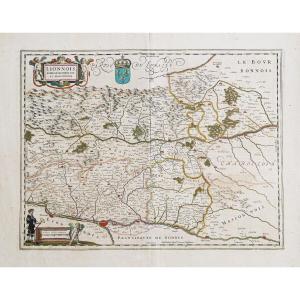
beautiful map, double page folded on middle, which was part of the great atlas of Blaeu, Wikipedia: The Atlas Maior, Atlas Blaeu or Theatrum Orbis Terrarum, is a collection of geographical maps, engra[...]
RARE MAP of ROUERGUE accompanied by the COAT OF “Leopard lion”. By Pierre DU VAL D'ABBEVILLE, geographer to His Majesty LOUIS XIV. ORIGINAL engraving with a chisel on steel. Beautiful hand watercolor [...]
Original engraving on steel with a chisel. Engraved by TASSIN (Christophe), known by mistake as Nicolas Tassin. He is in reality the King's geographical engineer. We do not know his dates of birth and[...]
Epreuve originale réalisée en 1648. Blaeu éditeur.
Coloris aquarelle.
Fine trace de pli au niveau du pli central.
Texte en gothique au verso.
Bon état.
Format feuille : 60,5 x 50 cm.
Format grav[...]
Epreuve originale réalisée en 1692. Rossi Domenico et Giacomo Cantelli auteurs.
Très belle épreuve sur papier fort.
Très bon état.
Format feuille : 62,5 x 47 cm.
Format gravure : 59 x 45,5 cm.
Or[...]
Proantic uses a cookie to analyze traffic and improve its service by using Google Analytics. Data sent to Google Analytics (frequency of visits to the site and pages visited) are anonymous. No other cookie tracks your activity, your personal data is not collected. Thank you for helping us to have better understanding how Proantic is used.


 Le Magazine de PROANTIC
 TRÉSORS Magazine
 Rivista Artiquariato