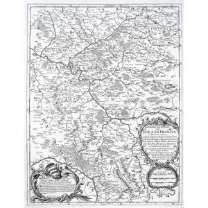
Epreuve originale réalisée en 1702. Nicolas de Fer graveur.
1 rousseur près du trait de cuivre dans la marge latérale gauche et 1 petit trou de ver dans la marge inférieure loin du sujet.
Bon état.
[...]
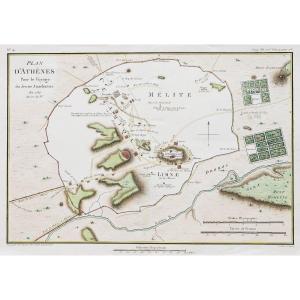
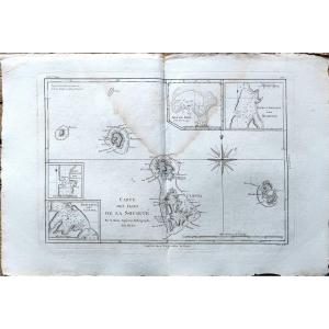
Le dessin préparatoire de cette aquatinte à été réalisé lors du Voyage autour du monde à bord du navire La Favorite commandée par Cyrille Laplace en 1830 . Peu courant.
Laplace's journey. Aquatint en[...]
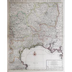
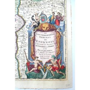
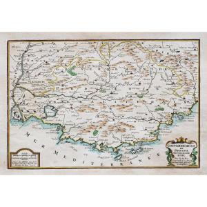
Representing the map of the GOVERNMENT OF ANTIBES, GRASSE, VALBONNE, NICE, etc... Beautiful original engraving, on steel with a burin and laid paper, by Nicolas TASSIN Hand watercolored Dimension(s): [...]
Original engraving on steel with a chisel and watermarked laid paper. Engraved by ROUX Antoine or Joseph Ange Antoine, (French -1765-1835). Marine painter. Hand watercolored. Dimensions: High. 29.5 cm[...]
Epreuve originale réalisée en 1848. Editée à Edimbourg par Johnston.
Coloris aquarelle.
Mouillures claires et plis de papier ancien.
Bon état.
Format feuille : 68 x 55,5 cm.
Original antique map [...]
gravure de Lemercier tirée de l'atlas national français représentant le département français de l'Allier France milieru du XIX sec.
33 cm x 56 a encadrer
gravure de Lemercier tirée de l'atlas national français représentant le département français du Finistère France milieru du XIX sec.
33 cm x 56 a encadrer
Original engraving on steel with a chisel. Engraved by JEFFERYS Thomas (1719 - 1771) - ENGLISH School - Engraver, son of a cutler. He became a cartographer around 1744. Bankrupt in 1766. Dimension(s):[...]
Very beautiful map of Nice, The city and the castle, Watercolored, Work from the 18th/19th century. In very good condition, Weight: 1300 gr. Dimensions: Height: 34 cm, Width: 44 cm. At sight: Height: [...]
Map of Asia, 2nd part
Second part of the map of Asia containing China and part of Tartary, India beyond the Ganges, the Isles of Sumatra, Java, Borneo, Moluccas, Philippines, and Japan.
Published un[...]
Map of Asia, 1st part
First part of the map of Asia containing Turkey, Arabia, Persia, India below the Ganges and Tartary which borders Persia and India.
Published under the auspices of Monsignor th[...]
Denmark and Sweden
18th c. map
dedicated to her majesty the King of Sweden, Gots and Vandals
by Guillaume Delisle, 1st geographer of the King, member of the Royal Academy of Sciences
completed by [...]
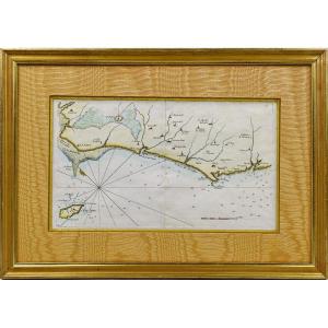
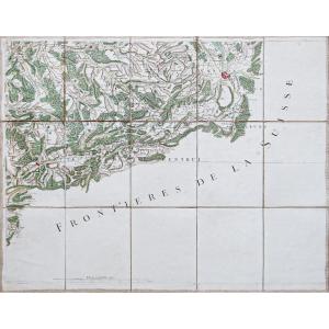
RARE NAVY MAP of VENDÉE - No. 27 - BEAUVOIR - L'ISLE D'YEU - SAINT HILAIRE - LES SABLES D'OLONNE - SAINT NICOLAS - Ep. 18th Original proof made in 1757 by Georges Louis Le ROUGE cartographer. Taken fr[...]
Original proof engraved in 1730. Mortier publisher. Colorful boundaries of the time. Oxidation in the right lateral margin not reaching the card. Good condition. Sheet size: 77.5 x 53.5 cm. Engraving [...]
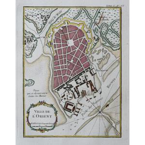
Epreuve originale réalisée en 1784. Tardieu graveur.
Beaux coloris aquarelle.
Très bon état.
Format feuille : 37,5 x 25,5 cm.
Format gravure : 32,5 x 21,5 cm.
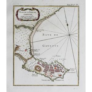
Original antique plan of 1784
Vou[...]
Marine map from the "Encyclopedic Atlas, containing ancient geography, and some maps on the geography of the Middle Ages, modern geography, and maps relating to physical geography", Paris, Hôtel de Th[...]
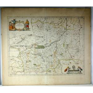
beautiful map, double page folded on middle, which was part of the great atlas of Blaeu, Wikipedia: The Atlas Maior, Atlas Blaeu or Theatrum Orbis Terrarum, is a collection of geographical maps, engra[...]
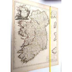
Beautiful large map : Kingdom of Ireland divided into provinces, counties and baronies, by Le Rouge, Georges-Louis (1712-1790). Cartographer, Edition date: 1745.
Decorated on top right with engraved [...]
RARE MAP of ROUERGUE accompanied by the COAT OF “Leopard lion”. By Pierre DU VAL D'ABBEVILLE, geographer to His Majesty LOUIS XIV. ORIGINAL engraving with a chisel on steel. Beautiful hand watercolor [...]
Marine map from the "Encyclopedic Atlas, containing ancient geography, and some maps on the geography of the Middle Ages, modern geography, and maps relating to physical geography", Paris, Hôtel de Th[...]
Epreuve originale réalisée en 1764. Bellin cartographe.
Coloris aquarelle.
Rousseurs claires dans les marges n’atteignant pas la carte.
Bon état.
Format feuille : 34 x 25,5 cm.
Format gravure : 2[...]
Original engraving on steel with a chisel. Engraved by TASSIN (Christophe), known by mistake as Nicolas Tassin. He is in reality the King's geographical engineer. We do not know his dates of birth and[...]
Grande Carta Corografica degli Stati di S.M. Re di Sardegna del 1772 di Stagnon e Borgonio
Large and Rare Chorographic Map of the States of H.M. the King of Sardinia in 1683 corrected and augmented[...]
Lithographie originale de 1870. Benoist dessinateur et lithographe.
Belle impression en couleurs.
Fines rousseurs du temps.
Très bon état.
Format feuille : 46 x 31 cm.
Vous pouvez consulter l’e[...]
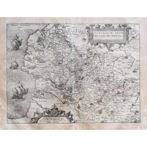
Epreuve originale réalisée en 1598. Abraham Ortelius cartographe.
Un pli ancien dans l’angle supérieur droit.
Texte en vieux français au verso.
1 petit trou de ver dans l’Andalousie.
Bon état.
Fo[...]
Epreuve originale réalisée en 1764. Bellin géographe.
Coloris aquarelle.
Rousseurs claires dans les marges.
Très bon état.
Format feuille : 34 x 24,5 cm.
Format gravure : 23 x 18 cm.
Original an[...]
This map is from the 18th century, no doubt about it. It is beautifully made. Unfortunately, we report numerous traces of humidity and spots of freckles, the card is a little warped at the bottom, a s[...]
Epreuve originale réalisée en 1760. Bellin géographe.
Coloris aquarelle.
Rousseurs claires dans les marges.
Très bon état.
Format feuille : 48 x 34 cm.
Format gravure : 24 x 18 cm.
Original anti[...]
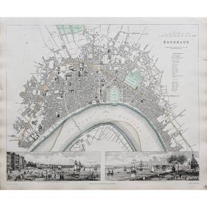
LA GUYENNE.
Large black and white lithographic map. Representation of this region of Gironde (Aquitaine), close to Bordeaux.
Period at the very end of the 19th century / beginning of the 20th centur[...]
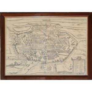
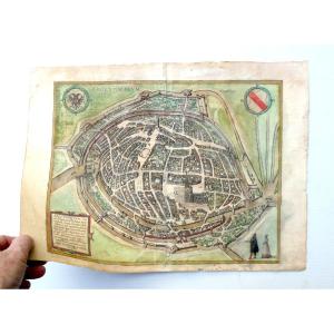
Plan of the city of Metz in 1572, taken from the book "Civitates Orbis Terrarum", and including 564 perspective views of the main cities of the world. The plan is framed in a pitch pine frame with ebo[...]
Epreuve originale réalisée en 1648. Blaeu éditeur.
Coloris aquarelle.
Fine trace de pli au niveau du pli central.
Texte en gothique au verso.
Bon état.
Format feuille : 60,5 x 50 cm.
Format grav[...]
Epreuve originale réalisée en 1760. Bellin géographe.
Coloris aquarelle.
Rousseurs claires dans les marges.
Très bon état.
Format feuille : 33,5 x 24 cm.
Format gravure : 23 x 19 cm.
Original an[...]
Epreuve originale réalisée en 1692. Rossi Domenico et Giacomo Cantelli auteurs.
Très belle épreuve sur papier fort.
Très bon état.
Format feuille : 62,5 x 47 cm.
Format gravure : 59 x 45,5 cm.
Or[...]
État : Excellent, la feuille a été doublée, ce qui la rendu solide. Les couleurs d’époque sont fraîches.
(Pour le texte suivant, je me suis largement inspiré d’une traduction d’un texte de Curtis Wri[...]
Due to the famous designer and cartographer Frans Hogenberg (1535-1590), published in famous 1584 work of Georg Braun (1541-1622), this copper engraving, perhaps not colored at period? engraved bowl: [...]
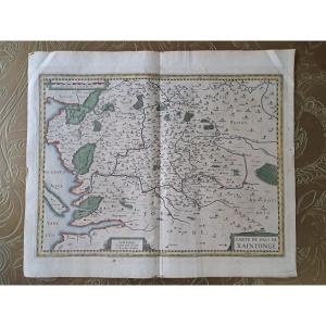
Very beautiful map of the Pais de Xaintonge, watercolor map, in good condition, presence of tape on the border, Map of the Pais de Xaintonge, Amstelodami Excusum apud Iudocum et Henricum Hondium. Arou[...]
Epreuve originale réalisée en 1638. Tassin géographe.
Coloris aquarelle.
2 petits trous de ver dans la marge supérieure loin du sujet.
Bon état.
Format feuille : 23 x 17 cm.
Format gravure : 15 x[...]
Epreuve originale réalisée en 1832. J. Henshall graveur et Clarke dessinateur.
Fine consolidation dans la marge latérale droite n’atteignant pas la carte.
Bon état.
Format feuille : 41 x 34,5 cm.
[...]
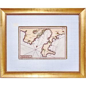
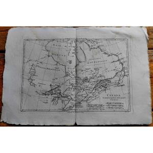
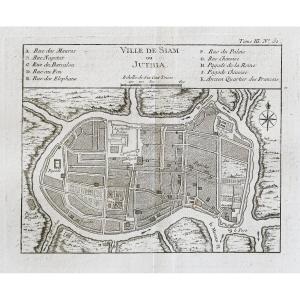
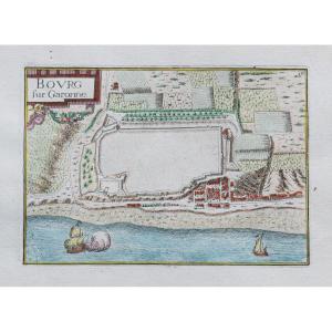
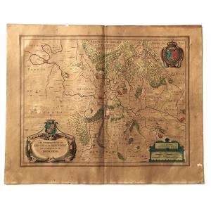
Epreuve originale réalisée en 1705. Nicolas de Fer géographe.
Beaux coloris aquarelle.
Très bon état.
Format feuille : 40,5 x 27,5 cm.
Format gravure : 34,5 x 23,5 cm.
Original antique map of 170[...]
Plan of the town and suburbs of Bourges, capital of the province of Berri. Original proof made in 1705. Nicolas de Fer cartographer. 1 small wormhole under the title block. Good condition. Sheet size:[...]
Epreuve originale réalisée vers 1750. Anonyme.
Une partie de la marge latérale gauche rapportée anciennement.
1 pli ancien dans l’angle inférieur gauche.
Bon état.
Format feuille : 46 x 38 cm.
Fo[...]
Drawn and handwritten map from 1823 of the Kingdom of France (under the reign of Charles X). Very beautiful work of cartography signed and dated, recent framing.
Epreuve originale réalisée vers 1760.
Coloris aquarelle.
Rousseurs éparses.
Bon état.
Format feuille : 35 x 25 cm.
Format gravure : 22 x 19,5 cm.
Original antique chart of 1760
Vous pouvez co[...]
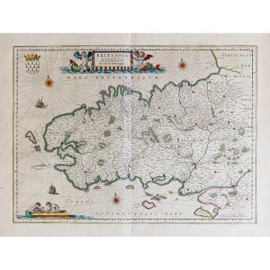
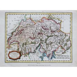
Switzerland with its subjects and allies from the best authorities.
Epreuve originale réalisée en 1807. J. Barlow graveur.
Coloris anciens.
2 rousseurs claires dans la marge supérieure n’atteignant[...]
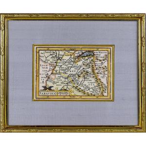
BEAUTIFUL and RARE regional map of SAVOIE - Beautiful ornamental title cartridge and a second cartridge with the scale of the map. The map was published around 1618 in a French edition of the work of [...]
Epreuve originale réalisée vers 1588. Guicciardini géographe.
Rousseurs uniformes sur la carte et quelques plis anciens dans les marges.
Etat correct.
Format feuille : 38,5 x 34 cm.
Format gravure[...]
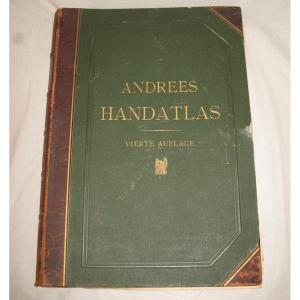
Handatlas de Andrees Collection of maps in German language dated 1899 Comprising 126 maps in plano and 137 side maps 4th edition by A. Scobel in Leipzig Drawing board type binding in strong cardboard [...]
RARE MAP of NIVERNOIS accompanied by the COAT OF COAT (Banded in gold and azure, with the engrailed border of Gueules) of this same region. By Pierre DU VAL D'ABBEVILLE, geographer to His Majesty LOUI[...]
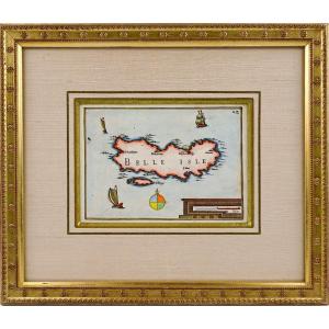
BEAUTIFUL and RARE engraving representing BELLE ISLE EN MER by TASSIN Nicolas. Original steel engraving with a chisel. Very decorative with boats, compass rose and cartouche. Dimension(s): Framing: Wi[...]
Epreuve originale gravée en 1750. Robert de Vaugondy cartographe.
Limites colorées de l’époque.
Légère oxydation classique dans les marges n’atteignant pas la carte.
Très bon état.
Format feuille [...]
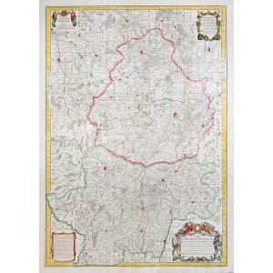
Grande épreuve originale réaliséeen 1720, datée 1780 lorsque Dezauche rachète les cuivres à la Maison Delisle.
Gravée sur 2 feuillets joints. Guillaume De L’Isle cartographe, Dezauche géographe succe[...]
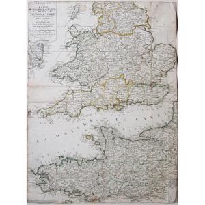
La Manche ou le Canal au septentrion duquel se trouve le Royaume d’Angleterre et au Midi les côtes de Bretagne et de Normandie.
Epreuve originale réalisée vers 1700. Nicolas de Fer cartographe.
Limi[...]
Lovely map from the beginning of the 17th century representing the sovereignties of Sedan, Raucourt and Doncheri, taken from the atlas of Guillaume Blaeuw published in Amsterdam. Period colors, very y[...]
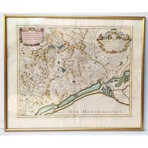
The diocese of Montpellier divided into nine archpriests, Hubert Jaillot, 53x43cm. Engraving dedicated “Monseigneur Charles Joachim Colbert, bishop of Montpellier (nephew of the great Colbert...) and [...]
Epreuve originale de Cassini réalisée en 1764. Editée chez Auvray en 1790.
Entoilées d’époque et montées en 15 sections.
Beaux coloris anciens.
1 rousseur dans la mer.
Très bon état.
Format feuil[...]
Original map engraved in 1760. Bellin geographer. Watercolor colors. Fine light foxing in the margins not reaching the map. Very good state. Sheet size: 48.5 x 33.5 cm. Engraving format: 34 x 25 cm. O[...]
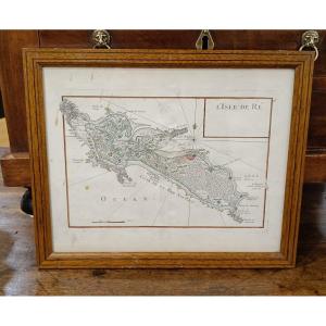
Lightly watercolored map from 1746 by Le Rouge, representing the Ile de Ré. Slight stains on the paper which do not affect the quality of this card. Pitchpin style oak frame with net 33 cm x 27 cm
Proantic uses a cookie to analyze traffic and improve its service by using Google Analytics. Data sent to Google Analytics (frequency of visits to the site and pages visited) are anonymous. No other cookie tracks your activity, your personal data is not collected. Thank you for helping us to have better understanding how Proantic is used.


 Le Magazine de PROANTIC
 TRÉSORS Magazine
 Rivista Artiquariato