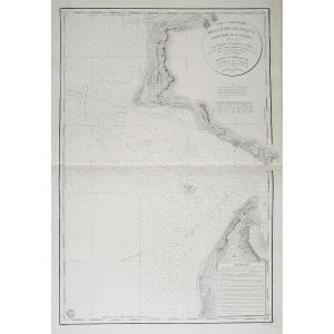
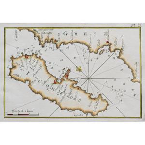
Carte originale levée en 1825 et gravée en 1831. Beautemps-Beaupré ingénieur hydrographe.
Infimes traces de rousseurs dans la marge droite. Très bon état.
Format feuille : 94,5 x 66,5 cm.
Original [...]
Original Cassini proof produced in 1784. Published by Auvray. Vintage canvas and mounted in 21 sections. Very good state. Sheet size: 93.5 x 60 cm. Folded format: 20 x 13 cm. You can consult all the m[...]
Diocèse du Mans divisée par Doyennés ruraux.
Epreuve originale réalisée en 1653. Sanson d’Abbeville cartographe.
Limites colorées de l’époque.
Très bon état.
Format feuille : 59 x 44 cm.
Format g[...]
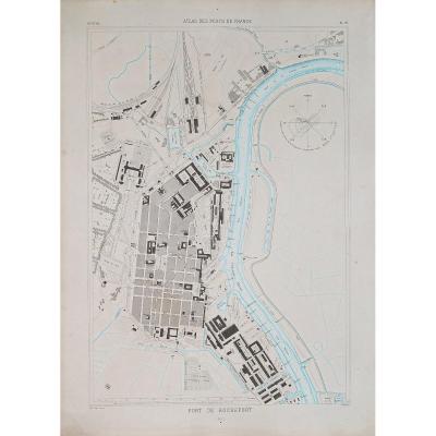
Environs du Fort St. Louis.
Epreuve originale réalisée en 1764. Bellin cartographe.
Coloris aquarelle.
Très bon état.
Format feuille : 34 x 25 cm.
Format gravure : 23,5 x 18,5 cm.
Original antiq[...]
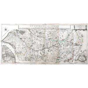
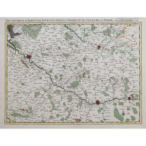
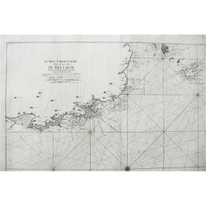
The course of the Somme around which are located the Ponthieu, the Amiénois, the Santerre and the Vermandois. Very large original proof made in 1709. Nicolas de Fer cartographer. Cards in 3 copper-cut[...]
Epreuve originale réalisée vers 1610. Gérard Mercator géographe.
Texte en latin au verso.
Mouillure fine dans la marge inférieure n’atteignant pas la carte, trace d’oxydation dans le pli central.
B[...]
Epreuve originale réalisée en 1745. Covens & Mortier éditeur.
Beaux coloris aquarelle.
Très bon état.
Format feuille : 64,5 x 55 cm.
Format gravure : 55,5 x 43 cm.
Original antique map of 1745.
[...]
Epreuve originale réalisée en 1650. Mariette éditeur.
Quelques rousseurs claires dans les marges n’atteignant pas la carte.
Bon état.
Format feuille : 52,5 x 37 cm.
Format gravure : 40,5 x 32,5 cm[...]
Gravées par les ordres de son altesse Le Duc d’Orléans
Sans date. Vers 1760. 1 volume grand in-folio, (56 x 42 cm).
Élégant cartonnage d’attente bleu de l’époque. Quelques rousseurs classiques sur [...]
Epreuve originale réalisée en 1650. Hondius éditeur.
Beaux coloris anciens.
Classique renfort de papier au dos de la carte au niveau du pli central dans la marge inférieure.
Bon état.
Format feuil[...]
Epreuve originale réalisée vers 1750. Bellin géographe.
Beaux coloris anciens.
Bon état.
Format feuille : 32 x 23,5 cm.
Format gravure : 23 x 18 cm.
Original antique map of 1750.
Jacques-Nicol[...]
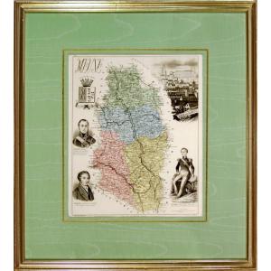
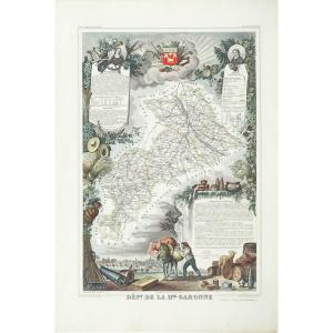
LA MEUSE (55) Departmental map Map from the book "New Illustrated Atlas, France and its Colonies by Migeon, Publisher. Dimension(s): Frame: Length 38 cm – Height 24 cm Width. Strip: 1.5 cm Condition: [...]
Epreuve originale réalisée en 1650. Hondius éditeur.
Beaux coloris anciens.
Très bon état.
Format feuille : 56,5 x 42cm.
Format gravure : 50 x 38 cm.
Original antique map of 1650.
Belle épreuve [...]
Canton de Neuilly.
2 grandes cartes originales éditées en 1874. Lefèvre cartographe.
Coloris aquarelle dans la Seine.
1 renfort au dos de la marge inférieure dans la carte 2.
Très bon état.
Forma[...]
Epreuve originale gravée en 1632. Leclerc éditeur & Jean Piquet dessinateur.
Rare édition française avec un texte explicatif au dos.
Belle impression bien gravée.
Très bon état.
Format feuille : 5[...]
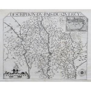
Epreuve originale gravée en 1594. Bougereau Maurice cartographe.
Première édition.
Belle impression bien contrastée.
Très bon état.
Format feuille : 54 x 40 cm.
Format gravure : 48,5 x 36 cm.
Ra[...]
Grande épreuve originale réalisée en 1719. Jaillot cartographe.
seconde édition.
Beaux coloris aquarelle.
Très bon état.
Format feuille : 106 x 72 cm.
Format gravure : 103,5 x 69 cm.
Original an[...]
Epreuve originale réalisée vers 1750. Bellin cartographe.
Beaux coloris aquarelle.
Très bon état.
Format feuille : 31,5 x 25 cm.
Format gravure : 28 x 19,5 cm.
Original antique plan of 1750.
Pla[...]
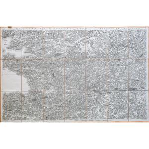
Epreuve originale de Cassini réalisée en 1759. Editée chez Dezauche en 1780.
Entoilées d’époque et montées en 21 sections.
Beaux coloris anciens.
Très bon état.
Format feuille : 92 x 59 cm.
Forma[...]
Découpée en 16 feuillets encollés sur une toile repliable pour faciliter sa consultation en voyage.
Le feuillet 152 de la carte correspond au nord de la Provence et au sud du Dauphiné. Il s'agit préc[...]
Epreuve originale réalisée en 1804. Joseph Roux cartographe.
Coloris aquarelle.
Très bon état.
Format feuille : 22 x 17 cm.
Format gravure : 21,5 x 14,5 cm.
Original antique map of 1804
Vous p[...]
Très grande épreuve originale gravée en 1696. Hubert Jaillot cartographe.
Très beaux coloris anciens.
Renfort au dos du centre de la marge supérieure.
Très bon état.
Format feuille : 94,5 x 60 cm.[...]
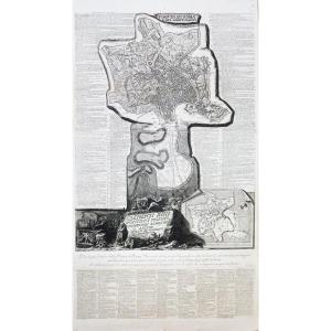
Giambattista Piranesi (1720-1778)
Pianta de Roma e del Campo Marzo.
Grande Epreuve originale réalisée en 1774. 1er tirage parisien. Eau-forte et burin.
Beau tirage gravée sur 3 feuillets joints à l[...]
Original proof engraved at the end of the 18th century. Very good state. Sheet size: 48 x 33.5 cm. Engraving format: 42 x 36.5 cm. You can consult all the maps and engravings available in your region [...]
Carte originale gravée en 1740.
Très bon état.
Coloris aquarelle.
Format feuille : 27 x 21,5 cm.
Format gravure : 26,5 x 20,5 cm.
Original antique map of 1740.
Carte illustrée d’un large cartouc[...]
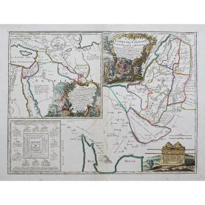
Land of Chanaan or Land Promised to Abraham and his posterity. Original proof made in 1790. Robert de Vaugondy geographer. At Delamarche. Colored boundaries of the time. Small stains in the top of the[...]
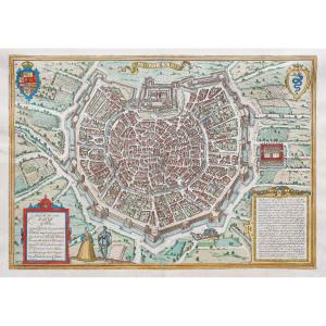
Plan original gravé en 1590. Braun et Hogenberg cartographes.
Beaux coloris aquarelle.
Texte explicatif en vieux français au verso.
Très bon état.
Format feuille : 53 x 39 cm.
Format gravure : 48[...]
Epreuve originale réalisée en 1849. Leménagev auteur.
Beaux coloris aquarelle.
Très bon état.
Format feuille : 45,5 x 35 cm.
Original antique plan of 1849.
Encart avec renvois de A à Z situant le[...]
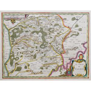
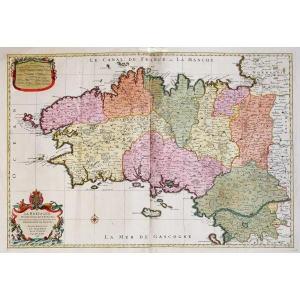
Les gouvernements de l’Ile de France et de la Champagne, et les généralités de Paris et de Chalons.
Epreuve originale réalisée en 1766. Desnos cartographe.
Petites rousseurs dans les marges n’atteig[...]
Carte originale de Cassini réalisée en 1779-1781, éditée chez Andriveau – Goujon vers 1815.
Entoilée d’époque et montée en 12 sections.
Format feuille : 72,5 x 40,5 cm.
Format repliée : 20 x 13,5 c[...]
Grande Carte du duché de Bourgogne, Comtés & pays adjacents dressée par les élus généraux de la Province.
Double cartes originales de Cassini réalisées en 1782.
Entoilées d’époque et montées en 21 s[...]
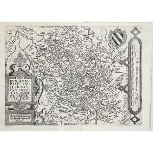
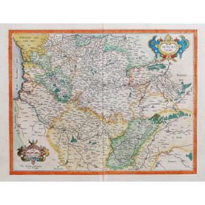
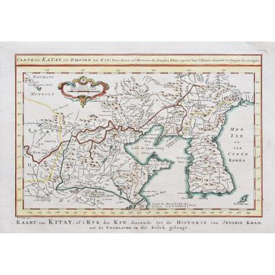
Alsace-Burgundiae in Ferioris Quae Ducatus
Carte originale gravée en 1596. Quad Matthias cartographe.
Texte explicatif en gothique au verso.
Très bon état.
Format feuille : 35 x 26 cm.
Format gra[...]
Original card engraved in 1860. Beautiful watercolor colors. Very good state. Sheet size: 53 x 36.5 cm. Famous mid-19th century edition published on rue Saint Jacques in Paris, illustrated with commen[...]
Beautiful color map of Beauce and its surroundings with the descriptive text in Dutch appearing on the back, after Joannes Blaeu (Amsterdam).
Copper: 385 x 500
Sheet: 495 x 590
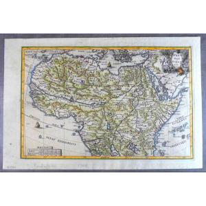
Beautiful map of the North of the African continent, due to the famous Jesuit cartographer Scherer, printed and nicely hand colored in Munich, who edited the Atlas Novus.
Nice cartridge with emblemat[...]
Epreuve originale réalisée en 1826.
Limites colorées de l’époque.
Excellent état
Format feuille : 51 x 41 cm.
Peu courante publication réalisée sous le règne de Charles X, illustrant les départem[...]
Epreuve originale gravée sur cuivre en 1660. Johanne Janson, d’après Samson.
Beaux coloris anciens.
Texte explicatif en latin au verso.
Format feuille : 60 x 47,5 cm.
Format gravure : 51 x 41 cm.[...]
Canton de Neuilly.
Grande carte originale réalisée en 1874. Lefèvre cartographe.
Coloris aquarelle dans la Seine.
Très bon état.
Format feuille : 95 x 64,5 cm.
Original antique map of 1874.
Larg[...]
Epreuve originale réalisée en 1630. Mercator géographe, Hondius éditeur.
Beaux coloris anciens.
Texte explicatif en latin au dos.
Trace de collage d’onglet dans les marges latérales, loin de la car[...]
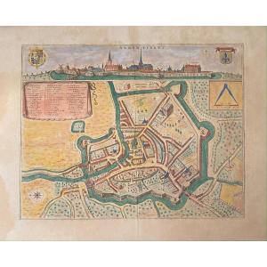
Plan original gravé en 1595. Braun et Hogenberg cartographes.
Beaux coloris aquarelle.
Texte explicatif en vieux français au verso.
Très bon état.
Format feuille : 52,5 x 38,5 cm.
Format gravure [...]
18th century maritime map.
Particular map of the Côtes de Bretagne from the Goulven cove to the Isle of Ouessant, probably by Le Rouge.
Dimensions: 58 x 80.3 cm 22.83 x 31.61 inches in the line
[...]
Original map from 1585. Ortelius Abraham cartographer & Simeoni Gabriel author. Very beautiful old colors. Explanatory text in Spanish on the back. Excellent condition. Sheet size: 48 x 31 cm. Origina[...]
From the Atlas: Novum Ac Magnum Theatrum Urbium Belgicae. Amsterdam, 1649
Etching in old colors on laid paper.
Descriptive text on the back in Latin.
At the subject: 390 x 490
Sheet: 485 x 595
Very beautiful geographical map representing the "General Governments of the March of Limosin and of Auvergne", dated 1751. - Dimensions: 67 x 53 cms. Note: there is a protective plastic on the card.
Épreuve originale gravée vers 1640. Hondius cartographe.
Beaux coloris aquarelle.
Chez Tavernier éditeur.
Très bon état.
Format feuille : 64,5 x 42 cm.
Format gravure : 50,5 x 38 cm.
Original [...]
Carte originale gravée sur en 1581. Abraham Ortelius cartographe.
Belle impression. Coloris aquarelle.
Explication de la carte en français au verso.
Format feuille : 61,5 x 43,5 cm.
Format cuivre[...]
Beautiful map of Beauvais and its surroundings with the descriptive text in Dutch appearing on the back, edited by Guiljelmum and Joannes Blaeu (Amsterdam).
Between 1631 and 1650.
Copper: 385 x 50[...]
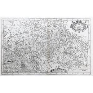
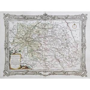
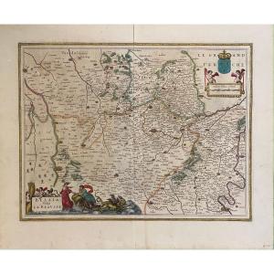
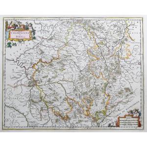
Gouvernement Général du Lyonnois comprenant les Provinces du Lyonnois, du Forez et du Beaujolois &c. sur les mémoires du P. Menestrier.
Epreuve originale réalisée en 1770. Pieter Mortier cartographe.[...]
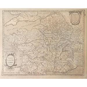
Epreuve originale réalisée en 1541. Laurent Fries cartographe.
Belle épreuve bien contrastée.
Texte explicatif en latin au verso.
Très bon état.
Format feuille : 52,5 x 38 cm.
Format gravure : 45[...]
Epreuve originale réalisée vers 1750.
Beaux coloris aquarelle.
Infime trace de rousseur dans le pli médian.
Très bon état.
Format feuille : 38,5 x 27,5 cm.
Format gravure : 32 x 23 cm.
Original [...]
Carte originale éditée en 1885.
Belle impression en couleurs.
Petites rousseurs éparses. Infime pincement de papier d’origine dans les deux angles supérieurs.
Très bon état.
Format feuille : 65,5 [...]
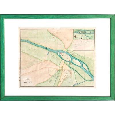
Map of Paris at the time of Julius Caesar.
Early 19th century colored print, c. 1825.
Anachronistic cartography of the city of Lutetia and its surroundings around 55 BC.
Indications:
"Plan of Lute[...]
Carte originale gravée en 1640. Johanne Jansson cartographe.
Beaux coloris anciens.
Texte explicatif en latin au verso.
Rousseur ancienne dans la marge droite, loin de l’encadrement.
Très bon état[...]
Epreuve originale réalisée en 1826.
Limites colorées de l’époque.
Excellent état
Format feuille : 51 x 41 cm.
Peu courante publication réalisée sous le règne de Charles X, illustrant les départem[...]
Map showing Franconia with the region of Heidelberg, Eichstätt, Cham and Schmalkalden.
circa 1627
Copper engraving in old color.
On the back, description in Latin.
Mercator, writer, astronomer a[...]
Proantic uses a cookie to analyze traffic and improve its service by using Google Analytics. Data sent to Google Analytics (frequency of visits to the site and pages visited) are anonymous. No other cookie tracks your activity, your personal data is not collected. Thank you for helping us to have better understanding how Proantic is used.


 Le Magazine de PROANTIC
 TRÉSORS Magazine
 Rivista Artiquariato