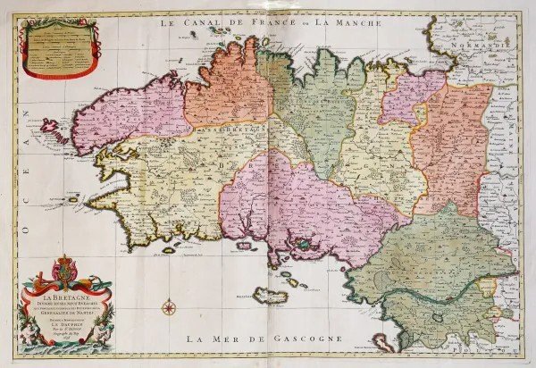
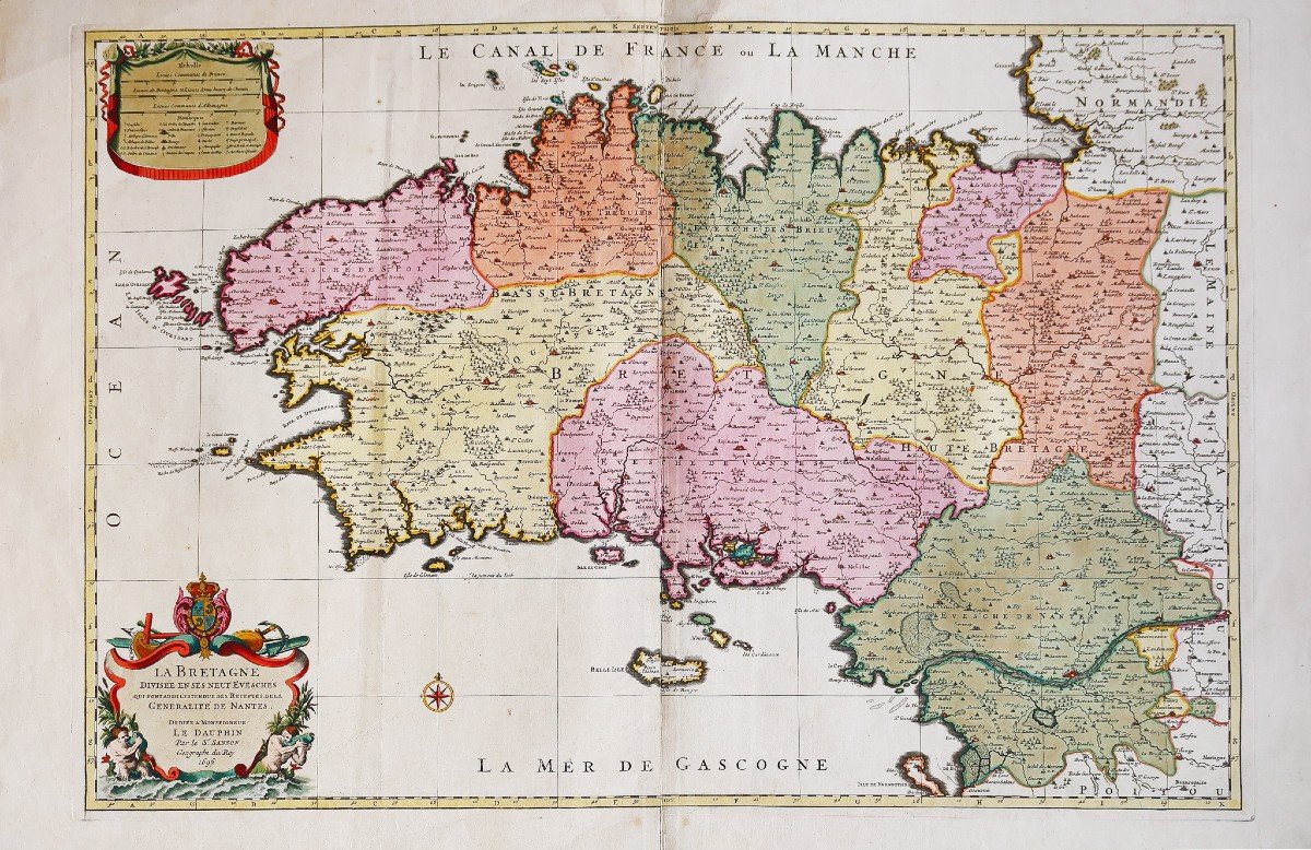
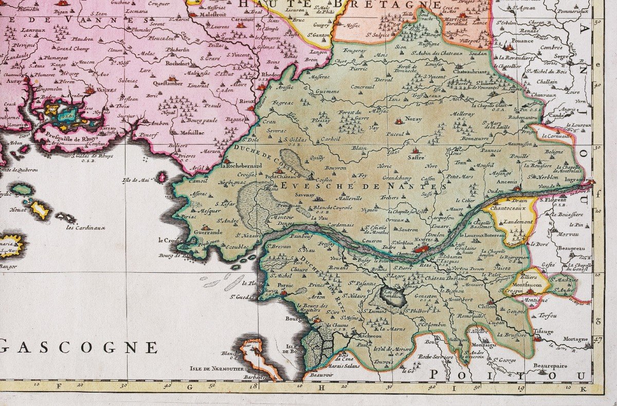
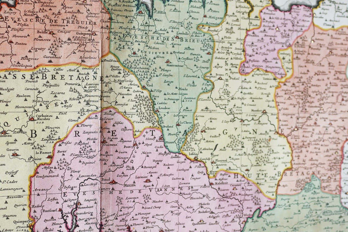
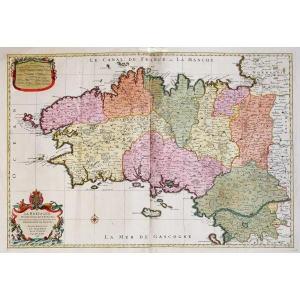


Old Geographical Map Of Brittany
Artist: Jaillot
Très grande épreuve originale gravée en 1696. Hubert Jaillot cartographe.
Très beaux coloris anciens.
Renfort au dos du centre de la marge supérieure.
Très bon état.
Format feuille : 94,5 x 60 cm.
Format gravure : 81 x 55 cm.
Original antique map of 1696.
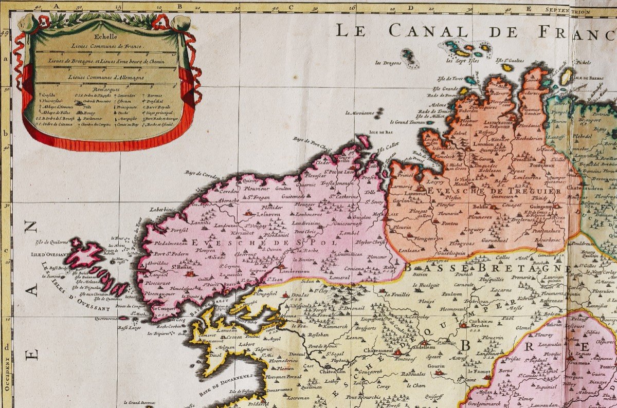
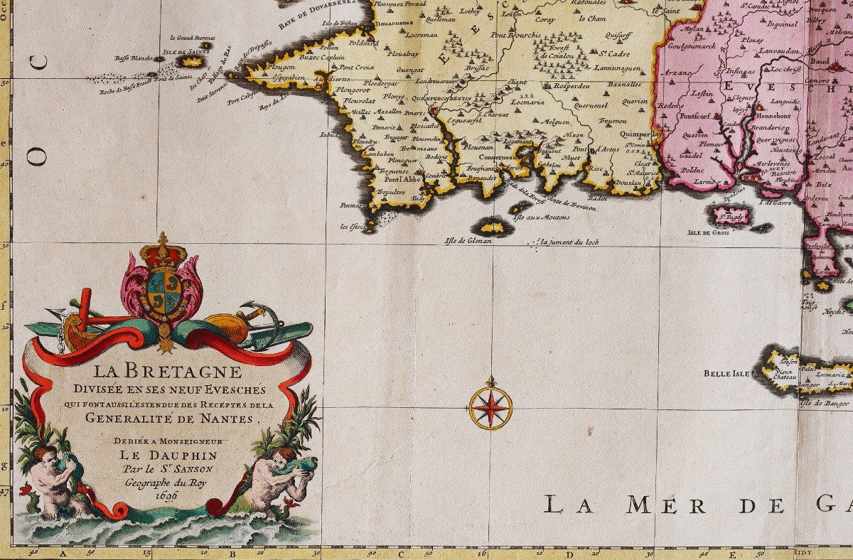
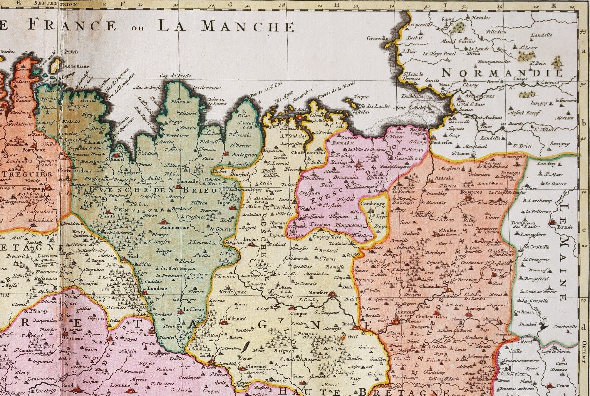
La plus grande carte de Bretagne réalisée au 17èmesiècle. Cartouche supérieur avec explications des symboles et remarques. Cartouche de titre avec une allégorie du monde de la mer. Rehaut de pigments or sur les principales villes et le cartouche de titre.
Vous pouvez consulter l’ensemble des cartes, livres et gravures disponibles sur votre région en cliquant sur le lien de notre site internet spécialisé en archives anciennes géographiques:
https://cartes-livres-anciens.com/categorie-produit/cartes-geographiques-anciennes-original-antique-maps/france/bretagne/
Règlement sécurisé par carte bancaire sur notre site internet en cliquant sur le lien ci-dessous:
https://cartes-livres-anciens.com/produit/cartes-geographiques-anciennes-original-antique-maps/france/bretagne/carte-geographique-ancienne-de-la-bretagne-10/
Toutes nos cartes et gravures sont accompagnées d’un certificat d’authenticité.
Alexis-Hubert Jaillot(1632-1712) est un ingénieur géographe et cartographe français, imprimeur à Paris, de la fin du XVIIe siècle et du début du XVIIIe siècle, au service du roi Louis XIV. « Les plus grandes cartes du 17èmesiècle »
Il publie de nombreux travaux de géographes contemporains ainsi que ses propres œuvres.
« L’Atlas François », Jaillot, 1692-1695, compilation des cartes de Nicolas Sanson (cartographe), Édité à Paris et à Amsterdam chez R et J Ottens.
Son travail sera continué par son fils, Bernard Jean Hyacinthe Jaillot (1673-1739), son petit-fils, Bernard Antoine Jaillot, ainsi que le beau-frère de celui-ci, Jean Baptiste-Michel Renou de Chauvigné dit Jaillot (1710-1780).
Very large original proof engraved in 1696. Hubert Jaillot cartographer. Very nice old colors. Reinforcement on the back of the center of the upper margin. Very good state. Sheet size: 94.5 x 60 cm. Engraving format: 81 x 55 cm. Original antique map of 1696. The largest map of Brittany made in the 17th century. Upper cartouche with explanations of symbols and remarks. Title cartouche with an allegory of the world of the sea. Enhanced with gold pigments on the main cities and the title cartouche. You can consult all the maps, books and engravings available in your region by clicking on the link of our website specializing in ancient geographical archives: https://cartes-livres-anciens.com/categorie-produit/cartes-geographiques -anciens-original-antique-maps/france/bretagne/ Secure payment by credit card on our website by clicking on the link below: https://cartes-livres-anciens.com/produit/cartes-geographiques-anciennes -original-antique-maps/france/bretagne/carte-geographique-ancienne-de-la-bretagne-10/ All our maps and engravings are accompanied by a certificate of authenticity. Alexis-Hubert Jaillot (1632-1712) was a French geographer and cartographer, printer in Paris, at the end of the 17th century and the beginning of the 18th century, in the service of King Louis XIV. “The greatest maps of the 17th century” He publishes numerous works by contemporary geographers as well as his own works. "L'Atlas François", Jaillot, 1692-1695, compilation of maps by Nicolas Sanson (cartographer), Published in Paris and Amsterdam by R and J Ottens. His work will be continued by his son, Bernard Jean Hyacinthe Jaillot (1673-1739), his grandson, Bernard Antoine Jaillot, as well as his brother-in-law, Jean Baptiste-Michel Renou de Chauvigné dit Jaillot (1710- 1780).
Très beaux coloris anciens.
Renfort au dos du centre de la marge supérieure.
Très bon état.
Format feuille : 94,5 x 60 cm.
Format gravure : 81 x 55 cm.
Original antique map of 1696.
La plus grande carte de Bretagne réalisée au 17èmesiècle. Cartouche supérieur avec explications des symboles et remarques. Cartouche de titre avec une allégorie du monde de la mer. Rehaut de pigments or sur les principales villes et le cartouche de titre.
Vous pouvez consulter l’ensemble des cartes, livres et gravures disponibles sur votre région en cliquant sur le lien de notre site internet spécialisé en archives anciennes géographiques:
https://cartes-livres-anciens.com/categorie-produit/cartes-geographiques-anciennes-original-antique-maps/france/bretagne/
Règlement sécurisé par carte bancaire sur notre site internet en cliquant sur le lien ci-dessous:
https://cartes-livres-anciens.com/produit/cartes-geographiques-anciennes-original-antique-maps/france/bretagne/carte-geographique-ancienne-de-la-bretagne-10/
Toutes nos cartes et gravures sont accompagnées d’un certificat d’authenticité.
Alexis-Hubert Jaillot(1632-1712) est un ingénieur géographe et cartographe français, imprimeur à Paris, de la fin du XVIIe siècle et du début du XVIIIe siècle, au service du roi Louis XIV. « Les plus grandes cartes du 17èmesiècle »
Il publie de nombreux travaux de géographes contemporains ainsi que ses propres œuvres.
« L’Atlas François », Jaillot, 1692-1695, compilation des cartes de Nicolas Sanson (cartographe), Édité à Paris et à Amsterdam chez R et J Ottens.
Son travail sera continué par son fils, Bernard Jean Hyacinthe Jaillot (1673-1739), son petit-fils, Bernard Antoine Jaillot, ainsi que le beau-frère de celui-ci, Jean Baptiste-Michel Renou de Chauvigné dit Jaillot (1710-1780).
Very large original proof engraved in 1696. Hubert Jaillot cartographer. Very nice old colors. Reinforcement on the back of the center of the upper margin. Very good state. Sheet size: 94.5 x 60 cm. Engraving format: 81 x 55 cm. Original antique map of 1696. The largest map of Brittany made in the 17th century. Upper cartouche with explanations of symbols and remarks. Title cartouche with an allegory of the world of the sea. Enhanced with gold pigments on the main cities and the title cartouche. You can consult all the maps, books and engravings available in your region by clicking on the link of our website specializing in ancient geographical archives: https://cartes-livres-anciens.com/categorie-produit/cartes-geographiques -anciens-original-antique-maps/france/bretagne/ Secure payment by credit card on our website by clicking on the link below: https://cartes-livres-anciens.com/produit/cartes-geographiques-anciennes -original-antique-maps/france/bretagne/carte-geographique-ancienne-de-la-bretagne-10/ All our maps and engravings are accompanied by a certificate of authenticity. Alexis-Hubert Jaillot (1632-1712) was a French geographer and cartographer, printer in Paris, at the end of the 17th century and the beginning of the 18th century, in the service of King Louis XIV. “The greatest maps of the 17th century” He publishes numerous works by contemporary geographers as well as his own works. "L'Atlas François", Jaillot, 1692-1695, compilation of maps by Nicolas Sanson (cartographer), Published in Paris and Amsterdam by R and J Ottens. His work will be continued by his son, Bernard Jean Hyacinthe Jaillot (1673-1739), his grandson, Bernard Antoine Jaillot, as well as his brother-in-law, Jean Baptiste-Michel Renou de Chauvigné dit Jaillot (1710- 1780).
1 850 €
Period: 17th century
Style: Other Style
Condition: Excellent condition
Material: Paper
Reference (ID): 909750
Availability: In stock
Print