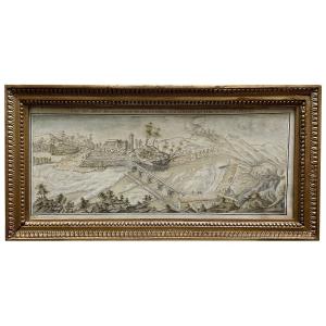
Ancient Plan Of Jerusalem
Original proof engraved at the end of the 18th century. Very good state. Sheet size: 48 x 33.5 cm. Engraving format: 42 x 36.5 cm. You can consult all the maps and engravings available in your region by clicking on the link of our website specializing in ancient geographical archives: https://cartes-livres-anciens.com/categorie-produit/cartes-geographiques-anciennes -original-antique-maps/moyen-orient/israel-palestine-jordanie/ Secure payment by credit card on our website by clicking on the link: https://cartes-livres-anciens.com/produit/cartes-geographiques- antique-original-antique-maps/middle-east/israel-palestine-jordan/ancient-map-of-jerusalem-3/ All our maps and engravings are accompanied by a certificate of authenticity.
220 €
Period: 18th century
Style: Other Style
Condition: Excellent condition
Material: Paper
Reference (ID): 896922
Availability: In stock
Print