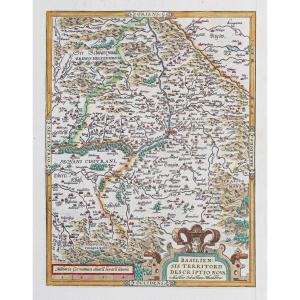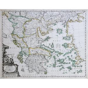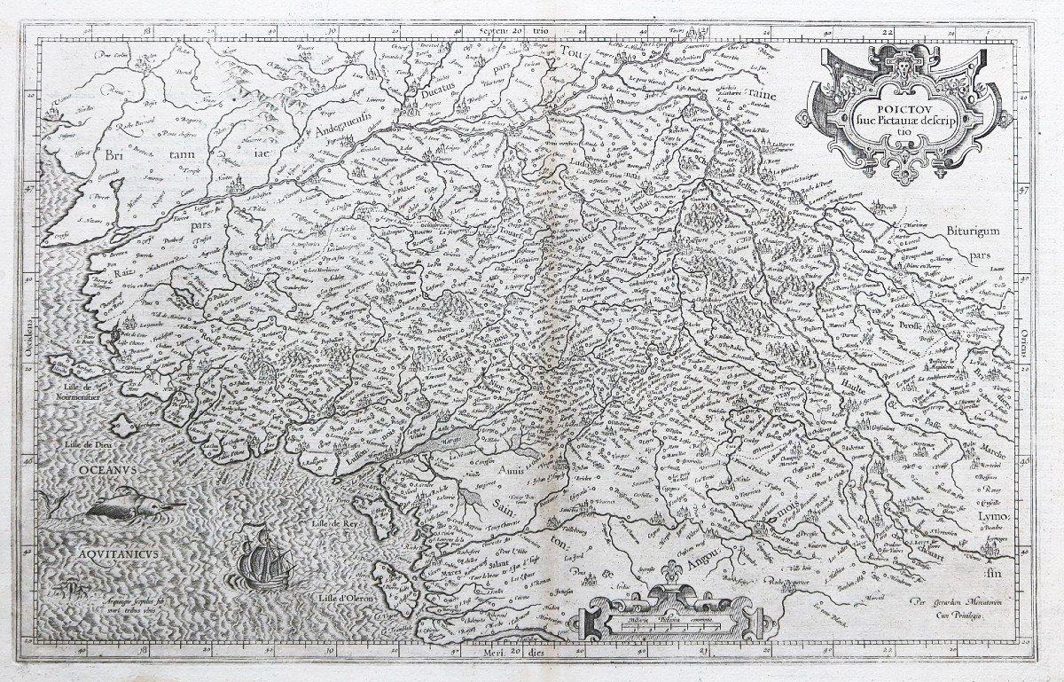
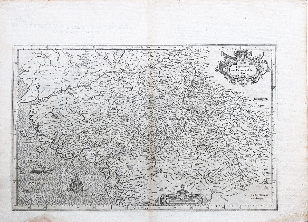
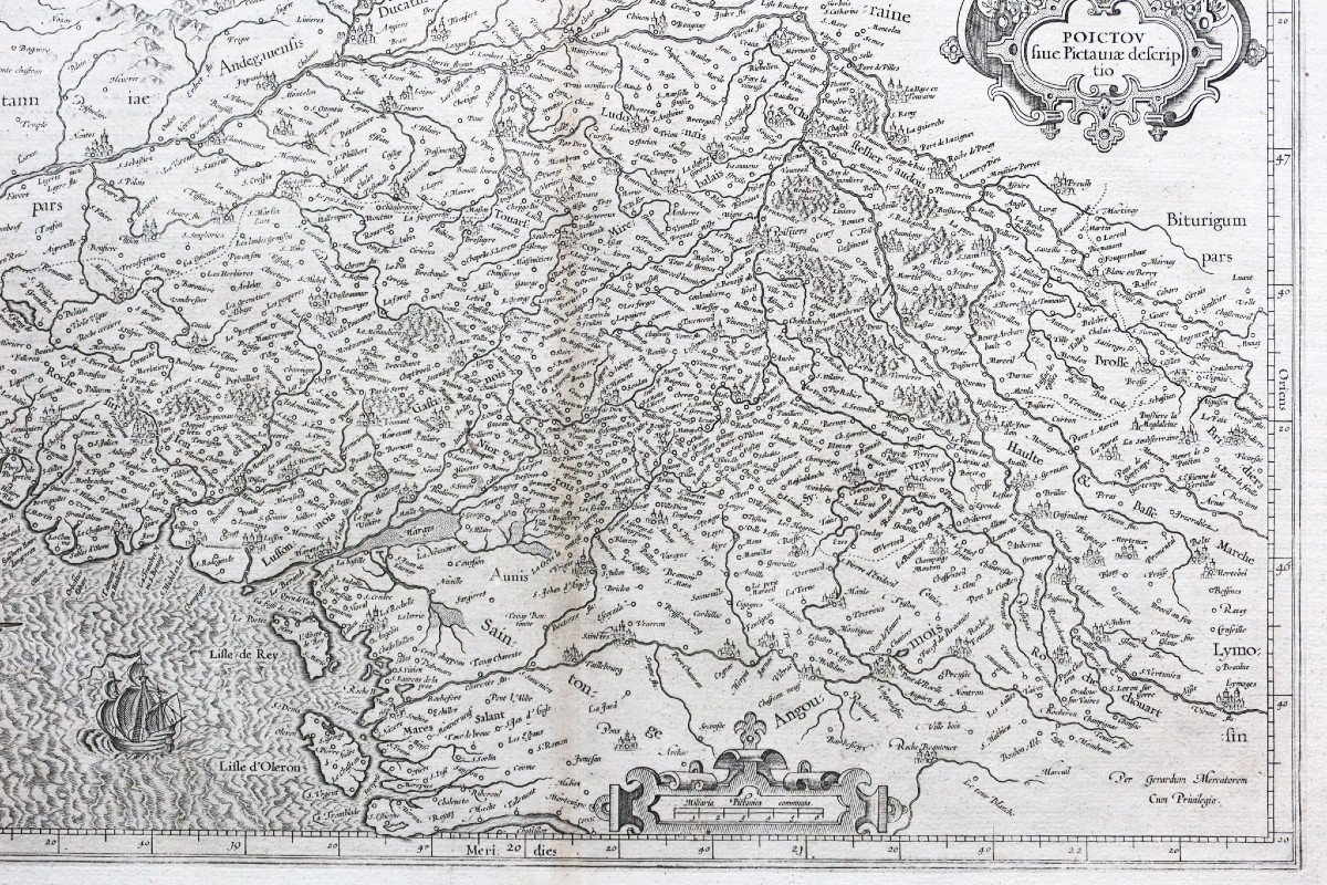
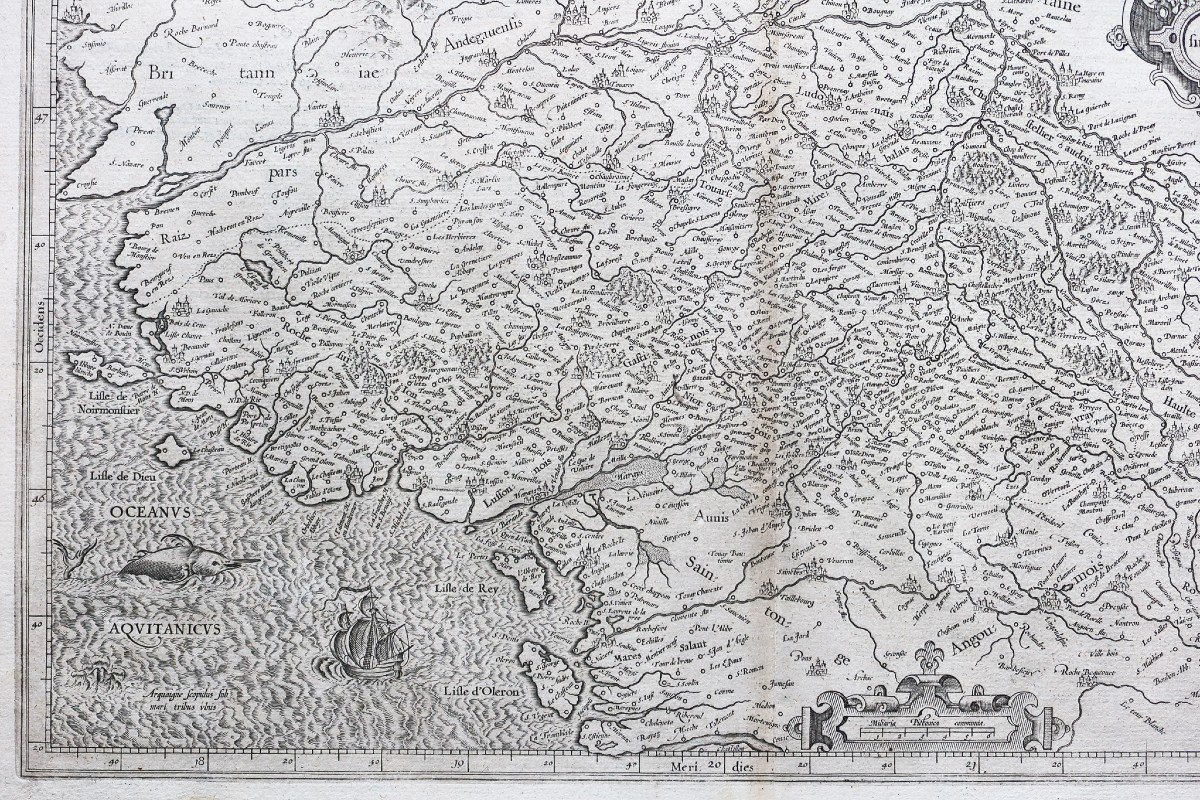
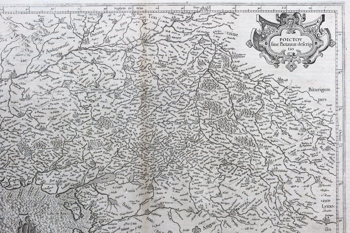
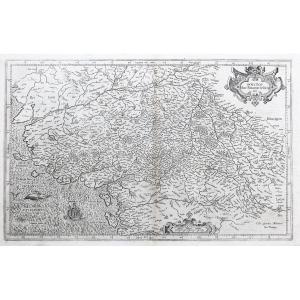


Old Geographical Map Of Poitou
Epreuve originale réalisée vers 1610. Gérard Mercator géographe.
Texte en latin au verso.
Mouillure fine dans la marge inférieure n’atteignant pas la carte, trace d’oxydation dans le pli central.
Bon état.
Format feuille: 54 x 39 cm.
Format gravure: 46,5 x 29 cm.
Original antique map around 1610.
Echelle des lieux, monstre marin et galion enluminent cette carte iconique du cartographe Gérard Mercator.
Vous pouvez consulter l’ensemble des cartes, livres et gravures disponibles sur votre région en cliquant sur le lien de notre site internet spécialisé en archives anciennes géographiques:
https://cartes-livres-anciens.com/categorie-produit/cartes-geographiques-anciennes-original-antique-maps/france/poitou-charentes/
Règlement sécurisé par carte bancaire sur notre site internet en cliquant sur le lien ci-dessous:
https://cartes-livres-anciens.com/produit/cartes-geographiques-anciennes-original-antique-maps/france/poitou-charentes/carte-geographique-ancienne-du-poitou-2/
Toutes nos cartes et gravures sont accompagnées d’un certificat d’authenticité.
Pendant près de soixante ans, au cours de la période la plus importante et la plus passionnante de l’histoire de la cartographie moderne,Gérard Mercatorfut le cartographe suprême.Son nom venait juste après Ptolémée, synonyme de la forme de projection cartographique encore utilisée aujourd’hui. Bien que n’étant pas l’inventeur de ce type de projection, il a été le premier à l’appliquer aux cartes de navigation sous une forme telle que les relèvements au compas puissent être tracés sur des cartes en ligne droite, offrant ainsi aux marins une solution à un problème de navigation de longue date en mer. Son influence transforma l’arpentage, et ses recherches et calculs le conduisirent à rompre avec la conception qu’avait laissé Ptolémée, de la taille et de la silhouette des continents, réduisant radicalement la longueur longitudinale de l’Europe et de l’Asie et modifiant la forme de l’Ancien Monde, telle que visualisée au début du XVIe siècle.
Mercator est né à Rupelmonde en Flandre et a étudié à Louvain auprès de Gemma Frisius, écrivaine, astronome et mathématicienne néerlandaise. Il s’y établit en tant que cartographe, créateur d’instruments et de globe, et à vingt-cinq ans, dessine et grave sa première carte (de Palestine) et produit ensuite une carte de Flandre (1540). L’excellence de son travail lui valut le patronage de Charles V pour lequel il construisit un globe. Malgré sa faveur auprès de l’empereur, il fut pris dans la persécution des protestants luthériens et accusé d’hérésie, heureusement sans conséquences graves. Nul doute que la crainte de nouvelles persécutions ait influencé son déménagement à Duisburg en 1552, où il poursuivit la production de cartes, de globes et d’instruments aboutissant aux cartes à grande échelle de l’Europe (1554), des îles Britanniques (1564) et de la célèbre Carte du monde 18 feuilles dessinées à sa nouvelle projection (1569). Toutes ces premières cartes sont extrêmement rares, certaines ne sont connues que par un seul exemplaire.
Plus tard, il se consacra à l’édition des cartes de Geographia de Ptolémée, reproduites aussi fidèlement que possible sous leur forme originale, et à la préparation de son recueil de cartes en trois volumes auquel, pour la première fois, le mot «Atlas» a été appliqué. Le mot a été choisi, a-t-il écrit, «pour honorer le Titan, Atlas, roi de Mauritanie, un philosophe savant, mathématicien et astronome». Les deux premières parties de l’Atlas ont été publiées en 1585 et 1589 et la troisième, les deux premières constituant une édition complète, en 1595, un an après le décès de Mercator. Les fils et les petits-fils de Mercator, nommés ci-dessus, étaient tous cartographes et contribuaient de diverses manières au grand atlas. Rumold, en particulier, fut responsable de l’édition complète en 1595. Après une seconde édition complète en 1602, les planches de cartes furent achetées en 1604 par Jodocus Hondius qui, avec ses fils, Jodocus II et Henricus, publia des éditions agrandies, qui dominèrent le marché de la carte pour les vingt à trente années suivantes.
Original proof produced around 1610. Gérard Mercator, geographer. Text in Latin on the back. Fine waterstaining in the lower margin not reaching the map, trace of oxidation in the central fold. Good condition. Sheet size: 54 x 39 cm. Engraving format: 46.5 x 29 cm. Original antique map around 1610. Scale of places, sea monster and galleon illuminate this iconic map by cartographer Gérard Mercator. You can consult all the maps, books and engravings available in your region by clicking on the link of our website specializing in ancient geographical archives: https://cartes-livres-anciens.com/categorie-produit/cartes-geographiques -anciens-original-antique-maps/france/poitou-charentes/ Secure payment by credit card on our website by clicking on the link below: https://cartes-livres-anciens.com/produit/cartes-geographiques -anciens-original-antique-maps/france/poitou-charentes/carte-geographique-ancienne-du-poitou-2/ All our maps and engravings are accompanied by a certificate of authenticity. For almost sixty years, during the most important and exciting period in the history of modern cartography, Gerard Mercator was the supreme cartographer. His name came just after Ptolemy, synonymous with the form of map projection still used today. Although not the inventor of this type of projection, he was the first to apply it to navigational charts in such a way that compass bearings could be plotted on maps in a straight line, thus providing sailors a solution to a long-standing navigational problem at sea. His influence transformed surveying, and his research and calculations led him to break with Ptolemy's conception of the size and shape of the continents, reducing radically the longitudinal length of Europe and Asia and altering the shape of the Old World, as visualized in the early 16th century. Mercator was born in Rupelmonde in Flanders and studied in Louvain with Gemma Frisius, a Dutch writer, astronomer and mathematician. He established himself there as a cartographer, creator of instruments and globes, and at the age of twenty-five, drew and engraved his first map (of Palestine) and then produced a map of Flanders (1540). The excellence of his work earned him the patronage of Charles V for whom he built a globe. Despite his favor with the emperor, he was caught up in the persecution of Lutheran Protestants and accused of heresy, fortunately without serious consequences. No doubt the fear of further persecution influenced his move to Duisburg in 1552, where he continued the production of maps, globes and instruments culminating in the large-scale maps of Europe (1554), the British Isles (1564 ) and the famous 18-sheet World Map drawn in its new projection (1569). All of these early cards are extremely rare, some are only known from a single copy. Later he devoted himself to publishing the maps of Ptolemy's Geographia, reproduced as faithfully as possible in their original form, and to the preparation of his collection of maps in three volumes in which, for the first time, the word "Atlas was applied. The word was chosen, he wrote, “to honor the Titan, Atlas, King of Mauritania, a learned philosopher, mathematician and astronomer.” The first two parts of the Atlas were published in 1585 and 1589 and the third, the first two constituting a complete edition, in 1595, a year after Mercator's death. Mercator's sons and grandsons, named above, were all cartographers and contributed in various ways to the great atlas. Rumold, in particular, was responsible for the complete edition in 1595. After a second complete edition in 1602, the map plates were purchased in 1604 by Jodocus Hondius who, together with his sons, Jodocus II and Henricus, published enlarged editions, who dominated the card market for the next twenty to thirty years.
290 €
Period: 17th century
Style: Other Style
Condition: Good condition
Material: Paper
Reference (ID): 944140
Availability: In stock
Print