THIS OBJECT WAS SOLD
Engraving - Rare Map Of Savoy "sabaudia" - Ep. Early 17th Century


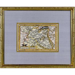


BEAUTIFUL and RARE regional map of SAVOIE - Beautiful ornamental title cartridge and a second cartridge with the scale of the map. The map was published around 1618 in a French edition of the work of Petrus Bertius. “Tabularum Geographicarum contractarum”, Amsterdam, publisher Jodocus Hondius. Dimension(s): Framing: High. 21.7 cm – Length. 26.5 cm - Width. Baguette: 1.4 cm, Condition: PERFECT CONDITION Period: EARLY 17th century (Circa 1618), Framing: CURRENT - Beveled gold fillet - Marie-Louise in blue wild silk and old gold fillet - Wooden baguette, water gilding, Observation (s): RARE & CURIOUS engraving. PAYMENT and TRANSPORT PAYMENTS ACCEPTED via PAYPAL / LYDIA / CB by VAD (distance selling) or by CHECK PACKAGES WILL BE POSTED WITHIN 3 DAYS. COMBINED SHIPPING POSSIBLE IF MULTIPLE ITEMS PURCHASED.
Explore similar pieces and discover your ideal find:
Old Maps