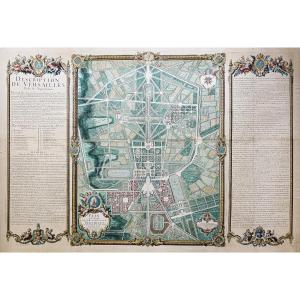
https://cartes-livres-anciens.com/produit/cartes-geographiques-anciennes-original-antique-maps/france/ile-de-france-78-versailles/plan-monumental-de-versailles-ville-et-chateau/Original plan from 1717[...]
Epreuve originale réalisée vers 1780. Denis et Patour éditeur.Fines traces de plis dans l’encadrement.Beaux coloris anciens.Bon état.Format feuille : 68 x 46 cm.Original antique map of 1780.Grande car[...]
Giovanni Maria Cassini 1745 – 1824
Six antique engravings from the "Nuovo Atlante Geografico Universale delineato sulle ultime osservazioni", published in Rome from 1792 to 1801: – World Map – Spheri[...]
Map of the French capital Paris and its environs published by cartographer Louis-Charles Desnos in 1787. Louis Charles Desnos (1725-1805) was the son of a cloth merchant from Pont-Sainte-Maxence and w[...]
Carte ancienne gouvernement du DauphinéEpreuve originale réalisée vers 1710. De Witt cartographe.Limites colorées de l’époque.Très bon état.Format feuille : 62,5 x 53,5 cm.Format gravure : 60,5 x 50 c[...]
This color map is from the 18th century. It was framed under glass in the 1960s. It is in generally acceptable condition, but not perfect, with some foxing. Our photos allow you to appreciate the qual[...]
Les élections de Tours, d’Amboise, de Loches, de Richelieu, de Chinon, de Bauge, de Montreuil Bellay et d’Angers, dans la généralité de Tours.Epreuve originale réalisée en 1711. Jaillot cartographe.Li[...]
LUTECE conquered by the French from the Romans; or Second Map of the City of Paris original old engraving, colored with watercolor, old colors 1705 by M.L.C.D.L.M. (meaning : Monsieur Le Commissaire D[...]
Rare historical document: Handwritten letter signed in 1786 by José Moñino y Redondo, better known as the Count of Floridablanca, a prominent 18th-century Spanish political figure and Minister of Stat[...]
Carte géographique ancienne de la Perse – Iran Grande épreuve originale en seconde édition de 1785 par Dezauche.Limites colorées de l’époque.Très bon état.Format feuille : 82 x 57,5 cm.Format gravure[...]
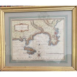
Map of the harbor of Brest and those of Bertheaume and Camaret, titled in a cartouche at the top left with the scale of the places, below, fleur-de-lis indicating the North. Original proof made around[...]
This rare map of ancient Greece depicts the region at the time of Agamemnon, Helen of Troy, and Homer. The map expands to show western Turkey. Decorated with an elaborate title cartouche symbolizing t[...]
Map of the Levant countries traveled by M Paul Lucas, drawn up on his memoirs and on some others by G De l'Isle of the Royal Academy – 1712 Paul Lucas (1664–1737) sculptor B. Ruyter Paul Lucas receive[...]
A significant historical episode of the city of Toulon, the 1707 siege took place in the context of England’s territorial expansion during the War of the Spanish Succession.Our map, has for legend : “[...]
Epreuve originale réalisée en 1771. Desnos géographe.Rousseurs claires dans les textes explicatifs.Bon état.Format feuille : 55,5 x 40 cm.Original antique map of 1771.Gouvernements d’Orléanois, de Tou[...]
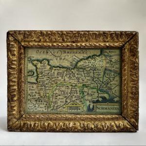
Map of Normandy (extending to Paris and Picardy in the East), in a very attractive little 18th-century carved and gilded wooden frame. Dimensions: height 12.8 cm - width 16.7 cm. Good overall conditio[...]
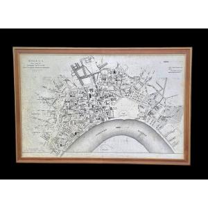
TURGOT (Michel-Etienne) . Louis BRETEZ. Map of Paris, begun in 1734, drawn and engraved under the orders of Turgot, 1739. Old part showing the center of Paris: Place Royale, Pont Marie, Rue Saint-Anto[...]
Pair of maps of Europe 18th century Cartographer R. Bonne "Orbis Vetus", The world in antiquity April 1781 Copper engraving Image 32 x 21 cm Full page: 37.5 x 26.5 cm Cartographer R. Bonne "General ma[...]
Map of the Kingdom of Naples divided into all its provinces Paris 1703 Map from the very beginning of the 18th century made by Hubert Jaillot, (1632- November 3, 1712) French geographer and cartograph[...]
Outstanding antique map of Asia by renowned cartographer Johann Baptist Homann, dated between 1720 and 1730, engraved in Nuremberg by the esteemed Homannische Erben workshop. This historical artifact [...]
Epreuve originale réalisée en 1787. Philippe de Pretot auteur.Beaux coloris aquarelle.Très bon état.Format feuille : 50,5 x 33 cm.Format gravure : 40 x 28 cm.Original antique map of 1787.Carte chorogr[...]
18th century map, geographical map of the southern part of Champagne, with Troyes in the center and Dijon at the lower limit. In a 20th century frame under glass, gilded and lacquered rod, professiona[...]
Epreuve originale réalisée en 1787. Vallet graveur.Beaux coloris aquarelle.2 rousseurs dans la marge inférieure n’atteignant pas la carte.Bon état.Format feuille : 50,5 x 33,5 cm.Format gravure : 40,5[...]
Epreuve originale réalisée au 18e siècle. D’après Merian auteur.Impression bien contrastée.2 plis anciens.Bon état.Format feuille : 16 x 13 cm.Format gravure : 15 x 11,5 cm.Petit plan de la ville de L[...]
MOITHEY (Maurille-Antoine) Historical map of the city and suburbs of Paris, its growth from Philippe Auguste to the reign of Louis XV. Paris, Moithey, 1774. In 24 sections mounted on canvas and folded[...]
Old and very interesting map of the city of Bordeaux and its suburbs in 1775, under King Louis XVI after the major works of the intendants. Very detailed map, locating the main streets, avenues, squar[...]
Map of the Diocese of Castres, dedicated to Messire Augustin de Maupéou, Advisor to the King in his councils, Bishop of Castres, by his very humble and very obedient servant HUBERT JAILLOT, Geographer[...]
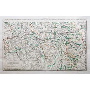
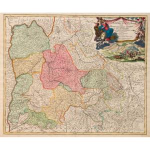
“Tabula Delphinatus et vicinarum regionnum” by Guillaume de L’Isle (Paris 1675-Paris1726). Copper engraving. In Amsterdam Covens and Mortier. Early 18th century. Sheet
54.5 x 65 cm
"Tabula Delphinatus vulgo, The General Government of DAUPHINÉ… Jo Baptista Homanno…" Edited by Johann HOMANN (1663-1724) German Geographer and Cartographer.
Copper engraving.
Printed in Nuremberg. E[...]
Et des mers voisines.
Epreuve originale réalisée en 1763. Bellin cartographe.
Coloris aquarelle.
Fines rousseurs claires éparses.
Très bon état.
Format feuille : 48 x 34 cm.
Format gravure : 47 [...]
Imperium Caroli magni, occidentis imperatoris complectens universam Galliam, in Hispania quidquid à Pyrenaeis jugis occurrit ad Iberum et Rubricatum usque fluvios, cum Balearibus insulis, in Italiã qu[...]
RARE Original proof made in 1757 by Georges Louis Le ROUGE cartographer. Nautical details: The half-fleur-de-lys indicating the north, the sandbanks, the currents and the sea depths are clearly indica[...]
Epreuve originale réalisée en 1705. Nicolas De Fer cartographe.
Limites colorées de l’époque.
Rousseurs claires dans les marges n’atteignant par la carte.
Bon état.
Format feuille : 40 x 28 cm.
O[...]
Epreuve originale réalisée en 1764. Bellin cartographe.
Coloris aquarelle.
Rousseurs claires éparses.
Très bon état.
Format feuille : 48 x 34 cm.
Format gravure : 30,5 x 25 cm.
Original antique [...]
Rare 18th century map from the second edition of Neptune François representing the "Map of the Costes de Poitou d'Aunis and Saintonge from the Isle of Noirmoustier to the mouth of the Bordeaux river" [...]
Epreuve originale réalisée en 1785. Bonne cartographe.
Beaux coloris aquarelle de l’époque.
Petit frottement de papier dans la partie gauche de la mer.
Très bon état.
Format feuille : 49,5 x 38,5 [...]
Epreuve originale réalisée vers 1760. Bellin cartographe.
Coloris aquarelle.
1 mouillure claire dans le haut de la marge supérieure loin de la carte.
Bon état.
Format feuille : 48 x 33,5 cm.
Form[...]
Epreuve originale réalisée en 1732. Homann héritier éditeur.
Coloris anciens.
Très bon état.
Format feuille : 62,5 x 54 cm.
Format gravure : 52 x 44 cm.
Belle carte de l’Île de la Corse. Un large[...]
Divisé en sept principales parties, et subdivisé en soixante six Royaumes.
Epreuve originale réalisée vers 1750. Seconde édition de 1790.
Robert de Vaugondy géographe.
Coloris aquarelle.
Très bon [...]
Carte des sept Îles à la côte de Bretagne.
Plan de l’Île aux Moines et ses mouillages.
Epreuve originale réalisée en 1764. Bellin cartographe.
Coloris aquarelle.
Très bon état.
Format feuille : 3[...]
Page 67 of a work from the beginning of the 18th century "Genesis"
Sheet 54 X 39 cm plate 19 X 30 cm
Very good condition
Date: 1704 or 1724
"Adjoining the Historical Table of the First Age of th[...]
Carte originale gravée en 1860.
Beaux coloris aquarelle.
Rousseurs claires.
Très bon état.
Format feuille : 52 x 37,5 cm.
Format gravure : 45 x 32 cm.
Original antique map of 1860.
Célèbre édit[...]
Epreuve originale réalisée vers 1792. Raymond géographe.
Coloris aquarelle.
Très bon état.
Format feuille : 41,5 x 33 cm.
Format gravure : 38,5 x 31 cm.
Original antique map of 1792.
L’une des p[...]
preuve originale réalisée vers 1760. Bellin cartographe.
Coloris aquarelle.
Fines rousseurs claires éparses.
Très bon état.
Format feuille : 47 x 33 cm.
Format gravure : 33 x 22 cm.
Original ant[...]
Epreuve originale réalisée en 1782. Pierre-François Tardieu graveur.
Très beaux coloris anciens.
Fines rousseurs claires dans les marges n’atteignant pas le plan.
Excellent état.
Format feuille : [...]
Family tree map Prince of Poland (18th century) Paper map representing the family tree of the Origin of the Princes and Dukes of the Family of Piaste and Origin of the First Princes and Dukes of Polan[...]
Map of the northern part of the United States, map by Pierre François Tardieu from 1792, published in Paris in the Atlas of Mentelle & Chanlaire in 1806. Double-page engraving, original coloring, all [...]
Original copperplate print, by JEFFERYS Thomas Hand-watercoloured. Dimension(s): Frame: Length 47.6 cm - Height 35.2 cm, condition(s): PERFECT CONDITION, Period: MID-18th century, Frame: CURRENT - Gol[...]
Epreuve originale réalisée en 1782. Antonio Zatta éditeur.
Beaux coloris aquarelle.
Légères rousseurs et marques du temps dans les marges.
Bon état.
Format feuille : 55,5 x 41,5 cm.
Format gravur[...]
Carte des Alpes Maritimes – Menton – Monaco – Nice
Epreuve originale réalisée en 1758. Villaret auteur.
Très bon état.
Format feuille : 67,5 x 46 cm.
Parfaite Impression cartographiant la vallée d[...]
Rare and Large 18th Century Map "The Western Coast of Louisiana and The Coast of New Leon" This is the 1794 edition by Laurie & Witthe of Thomas Jeffrys' map. Period proof Good general condition, some[...]
Proantic uses a cookie to analyze traffic and improve its service by using Google Analytics. Data sent to Google Analytics (frequency of visits to the site and pages visited) are anonymous. No other cookie tracks your activity, your personal data is not collected. Thank you for helping us to have better understanding how Proantic is used.


 Le Magazine de PROANTIC
 TRÉSORS Magazine
 Rivista Artiquariato