![Hand-drawn Map Of The French And Spanish Attack On Gibraltar In 1782. [circa 1782].](https://www.proantic.com/galerie/raphael-thomas/img/1812600-main-6a8f02136668c.jpg)
![Hand-drawn Map Of The French And Spanish Attack On Gibraltar In 1782. [circa 1782].-photo-2](https://www.proantic.com/galerie/raphael-thomas/img/1812600-6a8f02138743a.jpg)
![Hand-drawn Map Of The French And Spanish Attack On Gibraltar In 1782. [circa 1782].-photo-3](https://www.proantic.com/galerie/raphael-thomas/img/1812600-6a8f02138a8fc.jpg)
![Hand-drawn Map Of The French And Spanish Attack On Gibraltar In 1782. [circa 1782].-photo-4](https://www.proantic.com/galerie/raphael-thomas/img/1812600-6a8f02138c917.jpg)
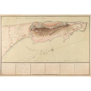


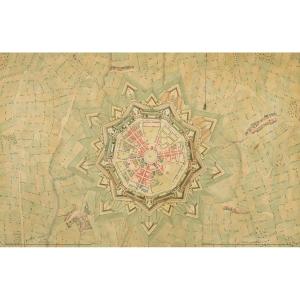
Hand-drawn Map Of The French And Spanish Attack On Gibraltar In 1782. [circa 1782].
Hand-drawn map. Pen, black ink, and colored wash. 63.1 x 92.7 cm. Minor wear along the lower edge, not extending to the caption.
Title at the bottom, above the caption: “Map of the attacks on the Fortress of Gibraltar in 1782, by the combined French and Spanish armies under the command of His Excellency Bishop the Duke of Crillon, Lieutenant General of the French Armies, and by the combined fleet of France and Spain under the command of Don Cordova, Lieutenant General of the Navy of His Catholic Majesty.” Below the caption: Scale of 1,000 toises.
An interesting map of Gibraltar from the late 18th century, showing the September 1782 attack by the French and Spanish armies against the British in Gibraltar, which they had been besieging since June 1779 as part of the American War of Independence. The attack, though massive, ended in a British victory. The siege of Gibraltar was finally lifted in February 1783, and British sovereignty over Gibraltar was confirmed by the Treaty of Versailles in September 1783, under which Spain, in turn, regained Menorca and Florida.
The legend at the bottom of the map identifies 42 locations within the British fortress of Gibraltar. It is preceded by a legend for land attacks and a legend for sea attacks, and followed by a topographical note on the Point of Europe and the Passage du Berger.
Excerpts:
“Legend of land attacks:
The areas shaded in yellow indicate the works carried out during the Blockade. Areas shaded in blue denote the batteries and communication lines constructed during the Siege of 1782. Areas shaded in both yellow and blue indicate the mortar batteries built behind and with the aid of the works constructed during the blockade.
The batteries in front of which is a bracket with an inscription indicating the number and type of gun barrels are those that fired during the Siege. The other batteries that were in the countervallation lines had been constructed during the Blockade. […]
The earthworks and batteries for the land attack began on the night of August 15–16 and were completed on the 31st. The batteries began firing on September 9. […] A total of 187 guns supported the attack from the sea. The siege was once again converted into a blockade on August 18, after supplies had been delivered to the 30,000 men—including 4,000 French soldiers—who made up the army; 17,000 of them were sent to garrisons and encampments.
Legend of the Sea Attacks:
[…] Total number of guns in the naval attack: 224. The combined naval force, anchored in the roadstead of Algeciras to blockade the fortress and intercept enemy reinforcements and supplies, consisted of: French ships: 15 / Spanish ships: 34 / 49 ships of the line, frigates, corvettes, and fire ships.
The British fleet consisted of 34 ships of the line, 8 frigates, and 4 fire ships, all copper-plated, escorting 8 large supply ships that they brought to the fortress on the 12th, 13th, and 18th. August 8, 1782.
Summary of firepower during the attack:
In the land-based batteries: 185. In the floating batteries, bomb galleys, and rowboats: 224. = 409 gun barrels.
Note: The floating batteries in the planned position are shaded in yellow, and those in the actual position are shaded in red.”
“Note: […] The British rendered this location impassable by making it sheer.” The British garrison numbered about 7,000 men, with approximately 600 gun barrels, including 50 or 60 mortars; when the fortress was resupplied, it lacked ammunition and had barely enough provisions for two months. All unnecessary guns had been removed from the fortress during the blockade.”
Ref. A14-79
Period: 18th century
Style: Louis 16th, Directory
Condition: Good condition
Reference (ID): 1812600
Availability: In stock