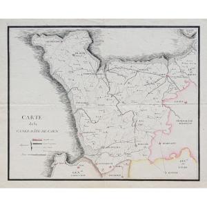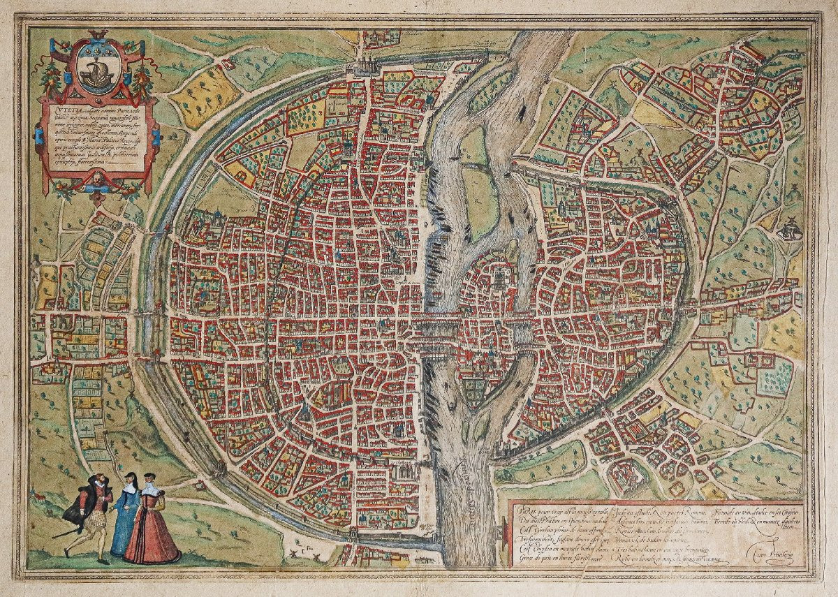

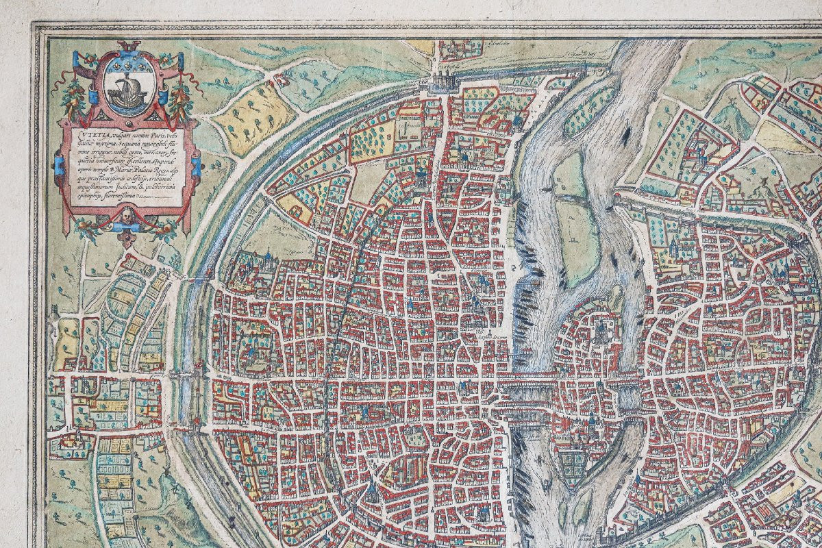


Antique Map Of Paris - Lutecia
Plan original gravé en 1583. Braun et Hogenberg cartographes.
Beaux coloris anciens.
Texte explicatif en latin au verso.
Doublé au verso sur papier japon pour préservation des coloris anciens.
Pincement de papier ancien dans le cartouche explicatif. Fine oxydation homogène.
Bon état.
Format feuille : 54 x 41 cm.
Format gravure : 49 x 34 cm.
Original antique map of 1583.
Les indications topographiques sont en français. Le champ est identique à celui du plan de Munster en 1550.
Il s’étend à l’est jusqu’à l’Abbaye Saint - Antoine, au nord jusqu’au Gibet de Monfaucon et à l’église de Montmartre, à l’ouest jusqu’au Faubourg Saint Honoré et à l’Abbaye de Saint Germain des Prés, au sud jusqu’au Gobelins.
Il représente l’état de Paris vers 1530. L’enceinte de Philippe Auguste et ses portes, qui seront abattues après 1530, sont très nettement visibles sur la rive droite.
Braun Georg & Franz
Hogenberg
Le Civitates
Orbis Terrarum de Georg Braun et Frans Hogenberg, collection d’une infinie
richesse, est une célébration de la cité européenne.
Cette œuvre procure à
l’amateur d’aujourd’hui autant de plaisir que lors de sa parution.
L’édition de ces gravures fut répartie sur 45
ans. Elles dépeignent avec force détails, quelques
530 villes d’Europe et d’ailleurs, sous leur
aspect d’il y a 400 ans.
L’intérêt de ces vues est considérable, conjuguant
les talents d’artistes de premier plan, de graveurs et de cartographes, dans
une succession de perspectives horizontales, de plans obliques ou verticaux.
Georg Braun, co-compilateur avec Franz Hogenberg,
préférait la vue oblique, car selon lui, « les villes doivent être
dessinées de telle façon que l’observateur puisse voir chaque route et chaque
rue, ainsi que tous les bâtiments et espaces libres ».
Détails curieux, rarement signalé, les plans et
vues du Civitates, dans la majorité
des cas, dépeignent une scène relativement sereine, une activité quotidienne et
paisible : agriculture, viticulture, pêche, commerce ou tout simplement
description de costumes locaux.
Les villes d’Autriche, de Hongrie ou des Pays-Bas
espagnols ne font pas exception, alors que pendant la compilation de cette
publication, elles furent toutes, à un moment ou à un autre, assourdies par le
vacarme de guerres civiles ou internationales.
Il suffit de comparer ces scènes tranquilles avec
la description violente des événements de l’époque qu’en donne Hogenberg et
d’autres, dans des Geschichtsblätter témoignant
des horreurs perpétuées au cours des guerres de religions, dans la lutte pour
la libération des Pays-Bas du joug espagnol, à partie de 1561, pour juger du
contraste entre ces deux approches.
Il n’est pas surprenant que de nombreux
collectionneurs considèrent ces gravures comme la plus précieuse édition du 16ème
siècle.
Son responsable d’édition, Georg Braun (1541 -
1622), ecclésiastique à Cologne, où il passa l’essentiel de sa vie, il fut
fortement influencé par Ortelius.
On sait peu de chose sur lui, si ce n’est qu’il
écrivit divers textes théologiques, aujourd’hui oubliés.
Au cours de la compilation du Civilates, il entretint une
correspondance avec les élus des villes, des artistes, ainsi que des
cartographes et les graveurs les plus importants de son temps.
On pense également que Braun a rédigé, ou tout du
moins supervisé, la plupart des textes imprimés au verso des gravures.
Parmi les graveurs sollicités par Braun, le plus
important est sans doute Frans Hogenberg (1535 - 1590), de Malines, en
Belgique. Après sa mort, en 1590, nombre de planches furent exécutées par
Abraham Hogenberg, son fils présumé.
C’est de son amitié avec Ortelius qui permit à
Georg Braun de faire la connaissance d’Hoefnagel (1542 – 1600), artiste
d’Anvers.
Celui-ci allait
jouer un rôle capital dans l’illustration des gravures. Hoefnagel, issu d’une
riche famille, voyagea partout en Europe. Il vécut à Anvers jusqu’en 1576.
S’établit ensuite à Cologne et travailla également en Bohème, Bavière et Tyrol
en compagnie du cartographe Ortelius.
Le talent d’Hoefnagel reposait sur sa soif de
connaissances, et c’est grâce à son observation des détails, qu’il put reproduire les structures de ces
cités, ainsi que le mode de vie de leurs habitants.
(John Goss).
Original plan engraved in 1583. Braun and Hogenberg cartographers.
Fine antique colors.
Explanatory text in Latin on verso.
Doubled on verso on japon paper for preservation of antique colors.
Pinch of antique paper in explanatory cartouche. Fine even oxidation.
Good condition.
Sheet size: 54 x 41 cm.
Engraving size: 49 x 34 cm.
Original antique map of 1583.
The topographical indications are in French. The field is identical to that of the Munster map of 1550.
It extends east to the Abbaye Saint - Antoine, north to the Gibet de Monfaucon and the church of Montmartre, west to the Faubourg Saint Honoré and the Abbey of Saint Germain des Prés, south to the Gobelins.
It represents the state of Paris around 1530. Philippe Auguste's enceinte and its gates, which were demolished after 1530, are clearly visible on the right bank.
Braun Georg & FranzHogenbergThe CivitatesOrbis Terrarum by Georg Braun and Frans Hogenberg, a collection of infiniteis a celebration of the European city.
This work providesas much pleasure as when it was first published.These engravings were published over a period of 45years. They depict some530 cities in Europe and beyond, as they looked400 years ago.
The interest of these views is considerable, combining the talentsthe talents of leading artists, engravers and cartographers, in a succession of horizontalin a succession of horizontal perspectives, oblique and vertical planes.
Georg Braun, co-compiler with Franz Hogenberg,preferred the oblique view, because in his view, "cities should be designeddrawn in such a way that the observer can see every road and streetstreet, as well as all buildings and open spaces". A curious detail, rarely reported, are the plans andCivitates plans and views, in the majoritydepict a relatively serene scene of peaceful, everyday activity: agricultureactivity: agriculture, viticulture, fishing, commerce or simplydescription of local costumes.
Towns in Austria, Hungary or the Spanish NetherlandsSpanish Netherlands are no exception, while during the compilation of thiswere all, at one time or another, deafened by the din of civil warsby the din of civil or international war.Compare these tranquil scenes with the violentthe violent description of the events of the time given by Hogenberg and othersin Geschichtsblätter, which bear witness to the horrorshorrors perpetuated during the Wars of Religion, in the struggle to liberate theliberation of the Netherlands from the Spanish yoke, from 1561 onwards, to judge thecontrast between these two approaches.It's hardly surprising that many collectorsconsider these engravings to be the most valuable edition of the 16th century.century.
Its publisher, Georg Braun (1541 -1622) was a clergyman from Cologne, where he spent most of his life.influenced by Ortelius.Little is known about him, except that he wrote various theologicaltheological texts, now forgotten.In the course of compiling the Civilates, he maintainedcorrespondence with elected city officials, artists, cartographers andcartographers and engravers of his time.
It is also believed that Braun wrote, or at least supervisedor at least supervised, most of the texts printed on the reverse of the engravings.Among the engravers Braun commissioned, the most importantmost important was Frans Hogenberg (1535 - 1590), from Mechelen, Belgium.Belgium. After his death in 1590, a number of plates were executed byAbraham Hogenberg, his presumed son.It was through his friendship with Ortelius thatGeorg Braun to meet the Antwerp artist Hoefnagel (1542 - 1600).artist.
Hoefnagel was to playplay a key role in the illustration of the engravings. Hoefnagel came from a wealthy familyfamily, traveled all over Europe. He lived in Antwerp until 1576.He then settled in Cologne, and also worked in Bohemia, Bavaria and Tyrolwith cartographer Ortelius.Hoefnagel's talent lay in his thirst for knowledgeHoefnagel's talent was based on his thirst for knowledge, and it was thanks to his observation of detail that he was able to reproduce the structures of these cities, as well as their way of life.and the way of life of their inhabitants.(John Goss).
Period: 16th century
Style: Other Style
Condition: Good condition
Material: Paper
Reference (ID): 1737738
Availability: In stock