

Large Old Wall Map Of Paris
Epreuve originale réalisée en 1811. Chamot Cartographe.
Limites colorées de l’époque.
Traces anciennes de punaises dans les marges n’atteignant pas la carte.
Format feuille : 157 x 108,5 cm.
Original antique map of 1811.
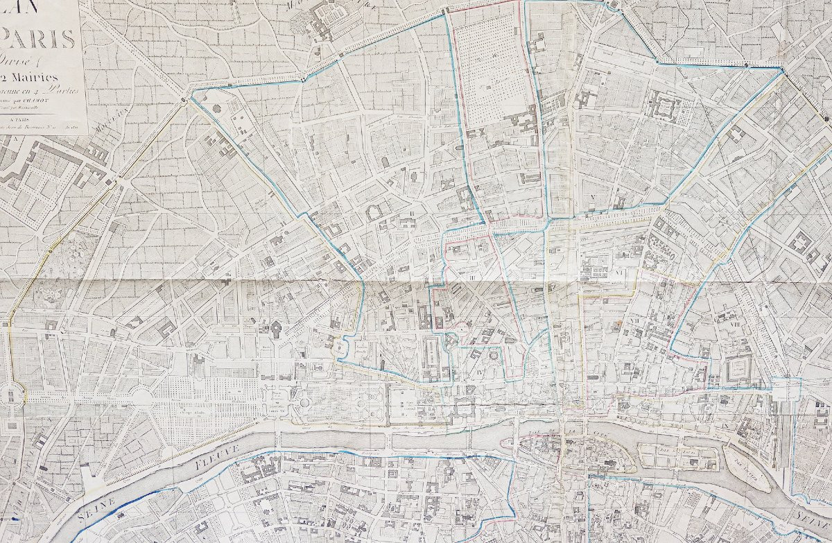
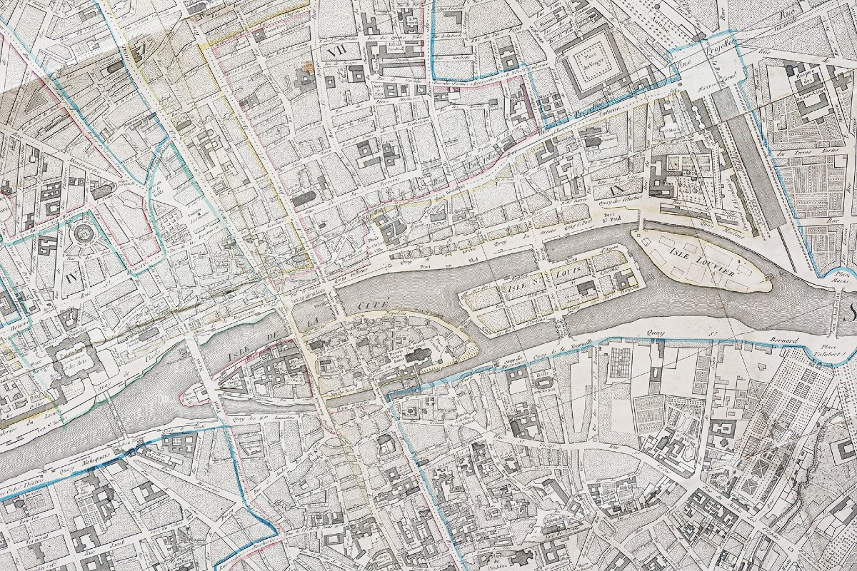
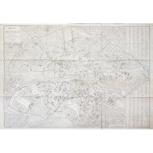
Plan de Paris divisé en 12 mairies subdivisées chacune en 4 parties. Dessiné par Chamot. Gravé par Bonnisselle. Edité à Paris chez Jean en 1811.
Le plan montre les premiers travaux d’embellissement et d’aménagement de voirie de Paris sous Napoléon, parmi lesquels figurent le pont des Arts, le pont d’Austerlitz et la nouvelle Morgue place du Marché-Neuf ou encore le quai d’Orsay.Le plan est accompagné d’une table alphabétique des rues, ponts, barrières, et des 12 mairies.
Vous pouvez consulter l’ensemble des cartes, livres et gravures disponibles sur votre région en cliquant sur le lien de notre site internet spécialisé en archives anciennes géographiques : https://cartes-livres-anciens.com/categorie-produit/cartes-geographiques-anciennes-original-antique-maps/france/paris-plans-maps/
Règlement sécurisé par carte bancaire sur notre site internet en cliquant sur le lien ci-dessous : https://cartes-livres-anciens.com/produit/cartes-geographiques-anciennes-original-antique-maps/france/paris-plans-maps/grand-plan-mural-ancien-de-paris/
Toutes nos cartes et gravures sont accompagnées d’un certificat d’authenticité.
Original proof produced in 1811. Chamot Cartographe.
Colored borders of the period.
Ancient thumbtack marks in the margins not reaching the map.
Sheet size: 157 x 108.5 cm.
Original antique map of 1811.
Plan de Paris divisé en 12 mairies subdivisées chacun en 4 parties. Drawn by Chamot. Engraved by Bonnisselle. Published in Paris by Jean in 1811.
The plan shows the first embellishments and roadworks in Paris under Napoleon, including the Pont des Arts, the Pont d'Austerlitz and the new Morgue on the Place du Marché-Neuf, as well as the Quai d'Orsay.The map is accompanied by an alphabetical table of streets, bridges, barriers, and the 12 town halls.
You can consult allmaps, books and engravings available for your region by clicking on thelink to our website specializing in old geographical archivesarchives: https://cartes-livres-anciens.com/categorie-produit/cartes-geographiques-anciennes-original-antique-maps/france/paris-plans-maps/
Secure payment by credit cardon our website by clicking on the link below: https://cartes-livres-anciens.com/produit/cartes-geographiques-anciennes-original-antique-maps/france/paris-plans-maps/grand-plan-mural-ancien-de-paris/
Allcards and engravings come with a certificate of authenticity.
Limites colorées de l’époque.
Traces anciennes de punaises dans les marges n’atteignant pas la carte.
Format feuille : 157 x 108,5 cm.
Original antique map of 1811.
Plan de Paris divisé en 12 mairies subdivisées chacune en 4 parties. Dessiné par Chamot. Gravé par Bonnisselle. Edité à Paris chez Jean en 1811.
Le plan montre les premiers travaux d’embellissement et d’aménagement de voirie de Paris sous Napoléon, parmi lesquels figurent le pont des Arts, le pont d’Austerlitz et la nouvelle Morgue place du Marché-Neuf ou encore le quai d’Orsay.Le plan est accompagné d’une table alphabétique des rues, ponts, barrières, et des 12 mairies.
Vous pouvez consulter l’ensemble des cartes, livres et gravures disponibles sur votre région en cliquant sur le lien de notre site internet spécialisé en archives anciennes géographiques : https://cartes-livres-anciens.com/categorie-produit/cartes-geographiques-anciennes-original-antique-maps/france/paris-plans-maps/
Règlement sécurisé par carte bancaire sur notre site internet en cliquant sur le lien ci-dessous : https://cartes-livres-anciens.com/produit/cartes-geographiques-anciennes-original-antique-maps/france/paris-plans-maps/grand-plan-mural-ancien-de-paris/
Toutes nos cartes et gravures sont accompagnées d’un certificat d’authenticité.
Original proof produced in 1811. Chamot Cartographe.
Colored borders of the period.
Ancient thumbtack marks in the margins not reaching the map.
Sheet size: 157 x 108.5 cm.
Original antique map of 1811.
Plan de Paris divisé en 12 mairies subdivisées chacun en 4 parties. Drawn by Chamot. Engraved by Bonnisselle. Published in Paris by Jean in 1811.
The plan shows the first embellishments and roadworks in Paris under Napoleon, including the Pont des Arts, the Pont d'Austerlitz and the new Morgue on the Place du Marché-Neuf, as well as the Quai d'Orsay.The map is accompanied by an alphabetical table of streets, bridges, barriers, and the 12 town halls.
You can consult allmaps, books and engravings available for your region by clicking on thelink to our website specializing in old geographical archivesarchives: https://cartes-livres-anciens.com/categorie-produit/cartes-geographiques-anciennes-original-antique-maps/france/paris-plans-maps/
Secure payment by credit cardon our website by clicking on the link below: https://cartes-livres-anciens.com/produit/cartes-geographiques-anciennes-original-antique-maps/france/paris-plans-maps/grand-plan-mural-ancien-de-paris/
Allcards and engravings come with a certificate of authenticity.
1 500 €
Period: 19th century
Style: Other Style
Condition: Good condition
Material: Paper
Reference (ID): 1734273
Availability: In stock
Print