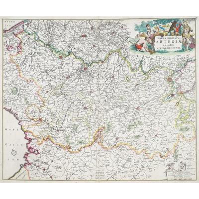
Old Map Of Brittany
Grande épreuve originale réalisée vers 1790. Robert de Vaugondy géographe.
Limites aquarellées de l’époque.
Fine oxydation dans les marges.
Très bon état.
Format feuille : 67 x 50,5 cm.
Format gravure : 62,5 x 49 cm.
Original antique map around 1790.
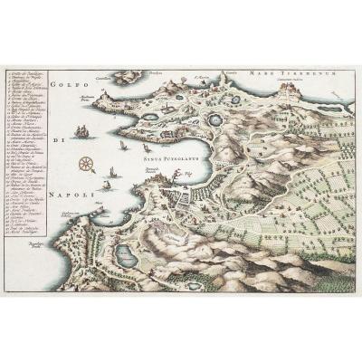
Grande carte du gouvernement général de Bretagne réalisée en seconde édition par Robert de Vaugondy. Large cartouche de titre décoratif avec allégories de la marine. Echelle des lieux.
Vous pouvez consulter l’ensemble des cartes, livres et gravures disponibles sur votre région en cliquant sur le lien de notre site internet spécialisé en archives anciennes géographiques :
https://cartes-livres-anciens.com/categorie-produit/cartes-geographiques-anciennes-original-antique-maps/france/bretagne/
Règlement sécurisé par carte bancaire sur notre site internet en cliquant sur le lien ci-dessous :
https://cartes-livres-anciens.com/produit/cartes-geographiques-anciennes-original-antique-maps/france/bretagne/carte-geographique-ancienne-de-la-bretagne-9/
Toutes nos cartes et gravures sont accompagnées d’un certificat d’authenticité.
Large original impression made around 1790. Robert de Vaugondy, geographer. Contemporary watercolor borders. Minor oxidation in the margins. Very good condition. Sheet size: 67 x 50.5 cm. Image size: 62.5 x 49 cm. Original antique map circa 1790. Large map of the General Government of Brittany, second edition, by Robert de Vaugondy. Large decorative title cartouche with allegories of the navy. Scale of locations. You can view all the maps, books, and engravings available for your region by clicking on the link to our website specializing in antique geographical archives: https://cartes-livres-anciens.com/categorie-produit/cartes-geographiques-anciennes-original-antique-maps/france/bretagne/ Secure payment by credit card on our website by clicking on the link below: https://cartes-livres-anciens.com/produit/cartes-geographiques-anciennes-original-antique-maps/france/bretagne/carte-geographique-ancienne-de-la-bretagne-9/ All our maps and engravings come with a certificate of authenticity. Gilles Robert de Vaugondy, known as Robert de Vaugondy, born in 1688 and died in 1766, was a French geographer and cartographer. In 1757, they produced the Universal Atlas, considered an authority for many years. The grandson of Nicolas Sanson, he was appointed geographer to the King. He was the father of the geographer and cartographer Didier Robert de Vaugondy (1723-1786), with whom he compiled a collection of world maps, published in 1757.
Limites aquarellées de l’époque.
Fine oxydation dans les marges.
Très bon état.
Format feuille : 67 x 50,5 cm.
Format gravure : 62,5 x 49 cm.
Original antique map around 1790.
Grande carte du gouvernement général de Bretagne réalisée en seconde édition par Robert de Vaugondy. Large cartouche de titre décoratif avec allégories de la marine. Echelle des lieux.
Vous pouvez consulter l’ensemble des cartes, livres et gravures disponibles sur votre région en cliquant sur le lien de notre site internet spécialisé en archives anciennes géographiques :
https://cartes-livres-anciens.com/categorie-produit/cartes-geographiques-anciennes-original-antique-maps/france/bretagne/
Règlement sécurisé par carte bancaire sur notre site internet en cliquant sur le lien ci-dessous :
https://cartes-livres-anciens.com/produit/cartes-geographiques-anciennes-original-antique-maps/france/bretagne/carte-geographique-ancienne-de-la-bretagne-9/
Toutes nos cartes et gravures sont accompagnées d’un certificat d’authenticité.
Gilles Robert de Vaugondy,ditRobert de Vaugondy, né en 1688 et mort en 1766, est un géographe et cartographe français. En 1757, ils réalisent l’Atlas Universel, considéré comme une autorité pendant de nombreuses années.
Petit-fils de Nicolas Sanson, il est nommé géographe du Roi. Il est le père du géographe et cartographe Didier Robert de Vaugondy (1723-1786), avec lequel il compose une collection de carte sur le Monde, parue en 1757.
Large original impression made around 1790. Robert de Vaugondy, geographer. Contemporary watercolor borders. Minor oxidation in the margins. Very good condition. Sheet size: 67 x 50.5 cm. Image size: 62.5 x 49 cm. Original antique map circa 1790. Large map of the General Government of Brittany, second edition, by Robert de Vaugondy. Large decorative title cartouche with allegories of the navy. Scale of locations. You can view all the maps, books, and engravings available for your region by clicking on the link to our website specializing in antique geographical archives: https://cartes-livres-anciens.com/categorie-produit/cartes-geographiques-anciennes-original-antique-maps/france/bretagne/ Secure payment by credit card on our website by clicking on the link below: https://cartes-livres-anciens.com/produit/cartes-geographiques-anciennes-original-antique-maps/france/bretagne/carte-geographique-ancienne-de-la-bretagne-9/ All our maps and engravings come with a certificate of authenticity. Gilles Robert de Vaugondy, known as Robert de Vaugondy, born in 1688 and died in 1766, was a French geographer and cartographer. In 1757, they produced the Universal Atlas, considered an authority for many years. The grandson of Nicolas Sanson, he was appointed geographer to the King. He was the father of the geographer and cartographer Didier Robert de Vaugondy (1723-1786), with whom he compiled a collection of world maps, published in 1757.
400 €
Period: 18th century
Style: Other Style
Condition: Excellent condition
Material: Paper
Reference (ID): 1717557
Availability: In stock
Print