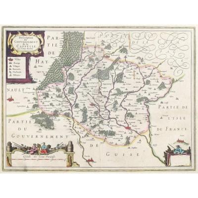
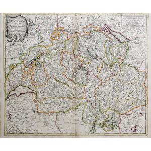
Old Map Of The Rhône Valley
Epreuve originale réalisée en 1670. P. Du Val géographe.
Trou dans la marge inférieure et traces de collages dans la frise inférieure avec léger manque d’impression.
Rousseur sous la ville de Dijon.
Limites colorées de l’époque.
Etat correct.
Format feuille : 60,5 x 43 cm.
Format gravure : 54,4 x 40,5 cm.
Original antique map of 1670.
Echelle des lieux. Cartouches nommant les comtés de Bourgogne et du sud de la France. Carte peu courante avec privilèges du roi.
Vous pouvez consulter l’ensemble des cartes, livres et gravures disponibles sur votre région en cliquant sur le lien de notre site internet spécialisé en archives anciennes géographiques :
https://cartes-livres-anciens.com/categorie-produit/cartes-geographiques-anciennes-original-antique-maps/france/rhone-alpes/
Règlement sécurisé par carte bancaire sur notre site internet en cliquant sur le lien ci-dessous :
https://cartes-livres-anciens.com/produit/cartes-geographiques-anciennes-original-antique-maps/france/bourgogne-franche-comte/carte-geographique-ancienne-de-la-vallee-du-rhone/
Toutes nos cartes et gravures sont accompagnées d’un certificat d’authenticité.
Né à Abbeville le 19 mai 1619, Pierre Duval est le fils d’un marchand consul et le neveu du célèbre cartographe Nicolas Sanson (1600-1667) qui lui transmet sa passion pour les cartes. Nommé « géographe ordinaire du Roy » dès 1650, Pierre Duval s’installe à Paris comme marchand éditeur. C’est un auteur très productif qui réalise plusieurs centaines de cartes gravées.
Original proof made in 1670. P. Du Val, geographer. Hole in the lower margin and traces of pasting in the lower border with slight printing loss. Foxing below the city of Dijon. Contemporary colored borders. Fair condition. Sheet size: 60.5 x 43 cm. Image size: 54.4 x 40.5 cm. Original antique map of 1670. Scale of locations. Cartouches naming the counties of Burgundy and southern France. Uncommon map with royal privileges. You can view all the maps, books, and engravings available for your region by clicking on the link to our website specializing in antique geographical archives: https://cartes-livres-anciens.com/categorie-produit/cartes-geographiques-anciennes-original-antique-maps/france/rhone-alpes/ Secure payment by credit card on our website by clicking on the link below: https://cartes-livres-anciens.com/produit/cartes-geographiques-anciennes-original-antique-maps/france/bourgogne-franche-comte/carte-geographique-ancienne-de-la-vallee-du-rhone/ All our maps and engravings come with a certificate of authenticity. Born in Abbeville on May 19, 1619, Pierre Duval was the son of a merchant consul and the nephew of the famous cartographer Nicolas Sanson (1600-1667), who passed on his knowledge to him. A passion for maps. Appointed "ordinary geographer to the King" in 1650, Pierre Duval settled in Paris as a merchant and publisher. He was a very prolific author who produced several hundred engraved maps.
300 €
Period: 17th century
Style: Other Style
Condition: En l'etat
Material: Paper
Reference (ID): 1673960
Availability: In stock
Print