Monumental Map Of Versailles – City And Palace
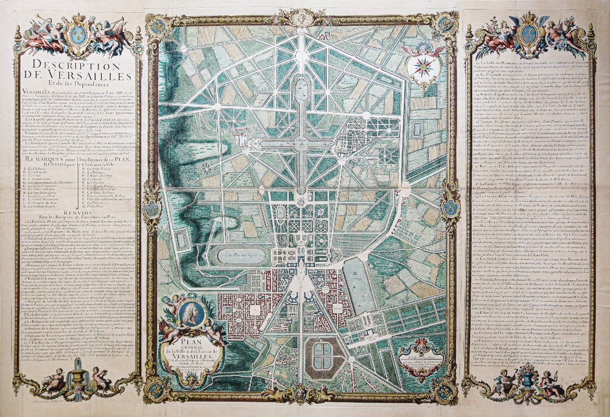
Original map from 1717. Pierre Lepautre, Architect.
Beautiful watercolor hues.
Slight traces of old creases.
Very good condition.
Sheet size: 124.5 x 85.55 cm.
Engraving size: 118 x 80 cm.
Antique original map from 1717.
Rare monumental map depicting Versailles and its outbuildings. Wide explanatory bands frame the map, featuring cross-references and notes to aid in understanding the map, including references to the Palace and the town, as well as to the groves and fountains in the park.
Scale of the sites, compass, with privilege, dated 1717 by Demortain, Paris, at the shop “Des Belles Estampes.”
Dedicated to the King by Pierre Lepautre, architect and official engraver to His Majesty.
You can view allthe maps, books, and engravings available for your region by clicking on thelink on our website specializing in historicalgeographic archives: https://cartes-livres-anciens.com/categorie-produit/cartes-geographiques-anciennes-original-antique-maps/france/ile-de-france-78-versailles/
Secure credit card paymenton our website by clicking the link below: https://cartes-livres-anciens.com/produit/cartes-geographiques-anciennes-original-antique-maps/france/ile-de-france-78-versailles/plan-monumental-de-versailles-ville-et-chateau/
Allof our maps and engravings come with a certificate of authenticity.
Pierre Lepautre (1652–1716) was a royal engraver and architectural draftsman, a leading figure in French ornamentation during the late reign of Louis XIV. His work, at the intersection of architecture, engraving, and ornamentation, marks a pivotal step toward the Rococo style.
Beautiful watercolor hues.
Slight traces of old creases.
Very good condition.
Sheet size: 124.5 x 85.55 cm.
Engraving size: 118 x 80 cm.
Antique original map from 1717.
Rare monumental map depicting Versailles and its outbuildings. Wide explanatory bands frame the map, featuring cross-references and notes to aid in understanding the map, including references to the Palace and the town, as well as to the groves and fountains in the park.
Scale of the sites, compass, with privilege, dated 1717 by Demortain, Paris, at the shop “Des Belles Estampes.”
Dedicated to the King by Pierre Lepautre, architect and official engraver to His Majesty.
You can view allthe maps, books, and engravings available for your region by clicking on thelink on our website specializing in historicalgeographic archives: https://cartes-livres-anciens.com/categorie-produit/cartes-geographiques-anciennes-original-antique-maps/france/ile-de-france-78-versailles/
Secure credit card paymenton our website by clicking the link below: https://cartes-livres-anciens.com/produit/cartes-geographiques-anciennes-original-antique-maps/france/ile-de-france-78-versailles/plan-monumental-de-versailles-ville-et-chateau/
Allof our maps and engravings come with a certificate of authenticity.
Pierre Lepautre (1652–1716) was a royal engraver and architectural draftsman, a leading figure in French ornamentation during the late reign of Louis XIV. His work, at the intersection of architecture, engraving, and ornamentation, marks a pivotal step toward the Rococo style.
4 800 €
Period: 18th century
Style: Other Style
Condition: Excellent condition
Material: Paper
Reference (ID): 1815997
Availability: In stock
Print