


Old Map Of The Poles - Arctic - Antarctic
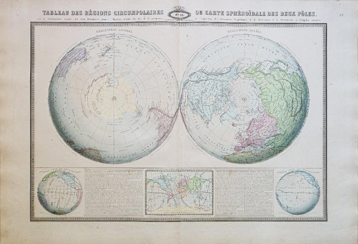
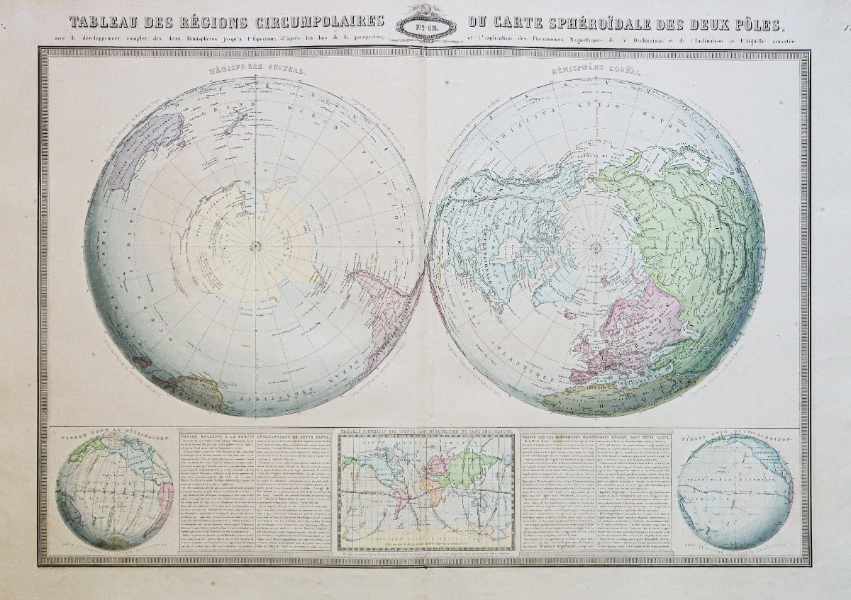
he circumpolar regions or spheroidal map of the two poles.
Large original proof produced in 1860. Garnier F.A cartographe.
Very fine color printing.
Sparse light brown spots.
Good condition.
Sheet size: 87 x 61 cm.
Engraving size: 78.5 x 52.5 cm.
Original antique map of 1860.
You can view all the maps and engravings available for your region by clicking here.consult all the maps and engravings available for your region byclicking on the link to our website specializing ingeographical archives: https://cartes-livres-anciens.com/categorie-produit/cartes-geographiques-anciennes-original-antique-maps/monde-cartes-marines/cartes-polaires/
Secure paymentby credit card on our website by clicking on the link: https://cartes-livres-anciens.com/produit/cartes-geographiques-anciennes-original-antique-maps/monde-cartes-marines/mappemonde/carte-ancienne-des-poles/
AllOur maps and engravings are accompanied by a certificate of authenticity.
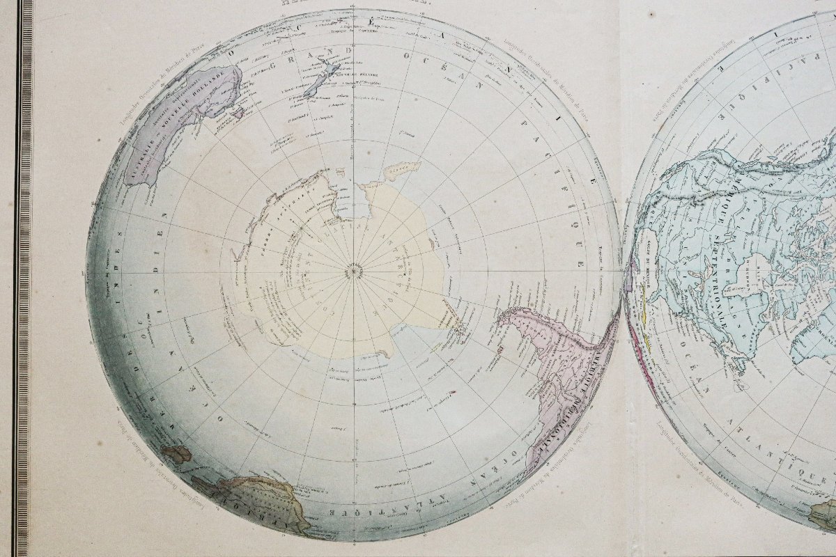
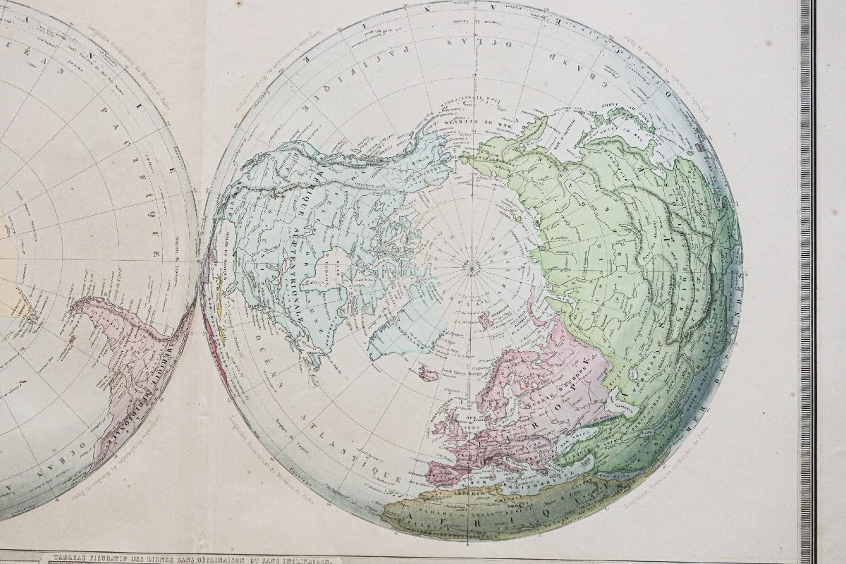
This map presents the Earth in a striking new way, in the form of two Hemispheres. The plane that crosses it perpendicular to its axis follows the line of the Equator. The two Poles appear at the centers: the North Pole shows the belt of land that radiates around it, and gives free rein to the imagination as to the true make-up of these vast, unexplored regions. The South Pole would seem to offer nothing but an immense expanse of water, were it not for the fact that the sparse land surrounding it indicates, on the contrary, the existence of a new Continent covered in ice, and whose details geography will perhaps one day have to record in its annals...
New geography produced by cartographer L.A Garnier in 1860, a member of the Société de Géographie since 1850.
The perfect sharpness of the colors, the choice of paper and the typographic execution were unanimously praised by the scientific community of the time. Uncommon.
Large original proof produced in 1860. Garnier F.A cartographe.
Very fine color printing.
Sparse light brown spots.
Good condition.
Sheet size: 87 x 61 cm.
Engraving size: 78.5 x 52.5 cm.
Original antique map of 1860.
You can view all the maps and engravings available for your region by clicking here.consult all the maps and engravings available for your region byclicking on the link to our website specializing ingeographical archives: https://cartes-livres-anciens.com/categorie-produit/cartes-geographiques-anciennes-original-antique-maps/monde-cartes-marines/cartes-polaires/
Secure paymentby credit card on our website by clicking on the link: https://cartes-livres-anciens.com/produit/cartes-geographiques-anciennes-original-antique-maps/monde-cartes-marines/mappemonde/carte-ancienne-des-poles/
AllOur maps and engravings are accompanied by a certificate of authenticity.
This map presents the Earth in a striking new way, in the form of two Hemispheres. The plane that crosses it perpendicular to its axis follows the line of the Equator. The two Poles appear at the centers: the North Pole shows the belt of land that radiates around it, and gives free rein to the imagination as to the true make-up of these vast, unexplored regions. The South Pole would seem to offer nothing but an immense expanse of water, were it not for the fact that the sparse land surrounding it indicates, on the contrary, the existence of a new Continent covered in ice, and whose details geography will perhaps one day have to record in its annals...
New geography produced by cartographer L.A Garnier in 1860, a member of the Société de Géographie since 1850.
The perfect sharpness of the colors, the choice of paper and the typographic execution were unanimously praised by the scientific community of the time. Uncommon.
480 €
Period: 19th century
Style: Other Style
Condition: Excellent condition
Material: Paper
Reference (ID): 1773389
Availability: In stock
Print