Beautiful colored engraving of Guyenne, one of the largest provinces of France under the Ancien Régime. It included various regions and provinces such as Périgord, Agenais, Quercy, and Rouergue. Very [...]
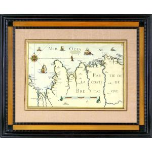
RARE NAUTICAL CHART OF CANCALE TO THE POTERIEU ISLANDS - SAINT MALO BAY - POINTE SAINT CAST - HERQUY - SAINT BRIEUX - Ep. END OF THE 17TH CENTURY PART OF THE BRITTANY COAST - SAINT MALORARE BAY NAUTIC[...]
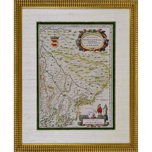
RARE MAP OF THE PRINCIPALITY OF BEARN (SOUTHWEST)Original intaglio engraving in period colors.It depicts the Principality of Béarn (Principatus Benearnia), a historical region located in the present-d[...]
Engraving GOVERNMENT OF PROUINS (PROVINS - 77) RARE Burin engraving on steel, by Christophe TASSIN, born in the early 1600s and died in 1660, in France, also known as Nicolas Tassin, Christophe Nicola[...]
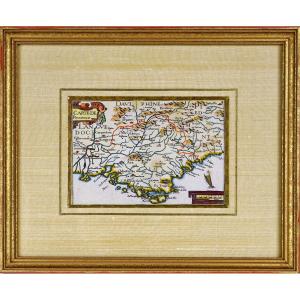
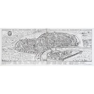
MAP AND GENERAL DESCRIPTION OF LANGUEDOC Drawn up by Jean Cavalier d'Agde, geographer to the king in 1621. In 1627, while he was 1st Consul of Agde, he married Dame d'Estienne at Notre-Dame du Grau. I[...]
Original steel engraving with a burin. Engraved by Tassin (Christophe), often mistakenly confused with Nicolas Tassin, he was in reality the King's engineer-geographer. Although his dates of birth and[...]
Original engraving on steel with a chisel. Engraved by TASSIN (Christophe), known by mistake as Nicolas Tassin. He is in reality the King's geographical engineer. We do not know his dates of birth and[...]
RARE MAP of ROUERGUE accompanied by the COAT OF “Leopard lion”. By Pierre DU VAL D'ABBEVILLE, geographer to His Majesty LOUIS XIV. ORIGINAL engraving with a chisel on steel. Beautiful hand watercolor [...]
Original engraving on steel with a chisel. Engraved by TASSIN (Christophe), known by mistake as Nicolas Tassin. He is in reality the King's geographical engineer. We do not know his dates of birth and[...]
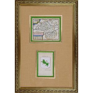
RARE MAP of NIVERNOIS accompanied by the COAT OF COAT (Banded in gold and azure, with the engrailed border of Gueules) of this same region. By Pierre DU VAL D'ABBEVILLE, geographer to His Majesty LOUI[...]
PERSOY, P.Britanniae, Amstedam, 1694. Richly enhanced print on paper. Rare map probably published in a composite atlas. It is dedicated to Jean SIX, Dutch poet and writer by Petrus PERSOY in the year [...]
Epreuve originale gravée en 1645 sur 2 feuillets joints. Jean Boisseau éditeur.
Renfort de papier japon au dos des grandes marges bien conservées, fines traces de plis.
Bon état.
Format feuille : [...]
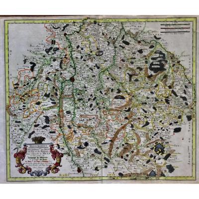
serious geographical map and dating from 1656 by Nicolas SANSON (1600-1667) titled: mediomatrici Archidiac of METZ of VIC and MARSAL in the eveche of METZ at the author 1656 in paris card named mediom[...]
Here is the beautiful celestial planisphere of Eimmart, one of the most sought after engravings in astronomy. Our engraving is identical to that of the National Library, same colors and dimensions, or[...]
Proantic uses a cookie to analyze traffic and improve its service by using Google Analytics. Data sent to Google Analytics (frequency of visits to the site and pages visited) are anonymous. No other cookie tracks your activity, your personal data is not collected. Thank you for helping us to have better understanding how Proantic is used.


 Le Magazine de PROANTIC
 TRÉSORS Magazine
 Rivista Artiquariato