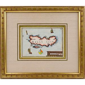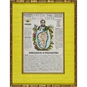


Engraving - Large Departmental Map "corsica" - By J. Henry - Ep. Early 19th
Artist: J. Henry
From NEW GEOGRAPHY and STATISTICS of FRANCE. By J. HENRY. Each page is presented in the same way: Famous person, presentation of the department, a part on the remarks and curiosities of the place - A presentation of the city and the Chief Lieu. RARE GEOGRAPHIC MAP. Dimension(s): Framing: High. 47 cm – Width. 36.7 cm - Width. Baguette: 1.5 cm, Condition: INTACT, Period: 1st HALF 19th century (Circa 1835), Framing: CURRENT - Beveled gold fillet - Marie-Louise in wild water green silk - Wooden baguette, water gilding aged, Observation(s): RARE & CURIOUS engraving. PAYMENT and TRANSPORT PAYMENTS ACCEPTED via PAYPAL / LYDIA / CB by VAD (distance selling) or by CHECK PACKAGES WILL BE POSTED WITHIN 3 DAYS. COMBINED SHIPPING POSSIBLE IF MULTIPLE ITEMS PURCHASED.
250 €
Period: 19th century
Style: Louis Philippe, Charles 10th
Condition: Perfect condition
Material: Paper
Width: 36.7 cm
Height: 47 cm
Reference (ID): 1275682
Availability: In stock
Print