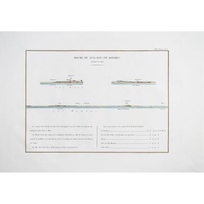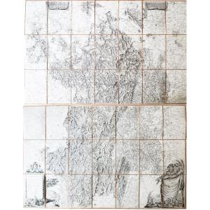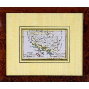
Cassini - Aubusson - Old Map
Artist: Cassini
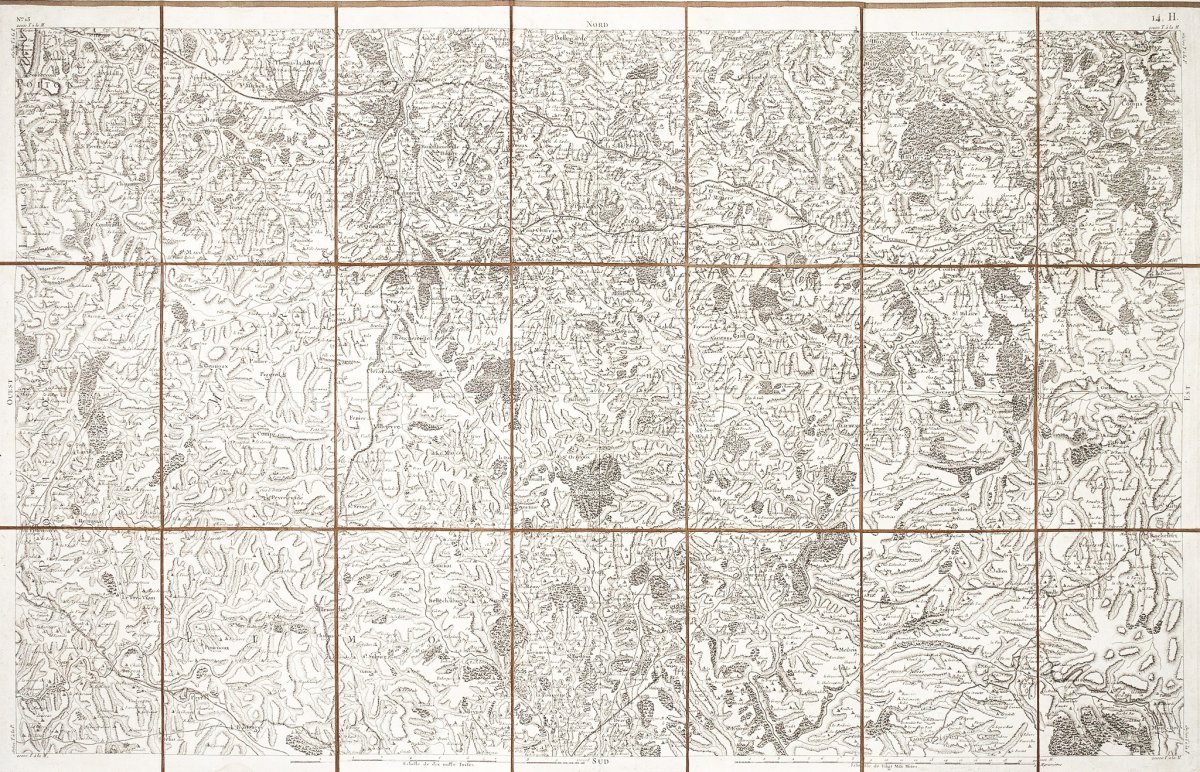
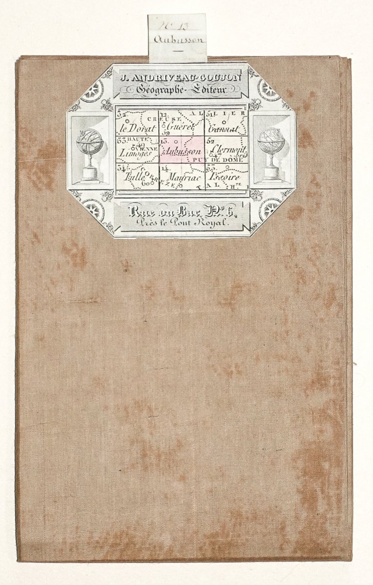
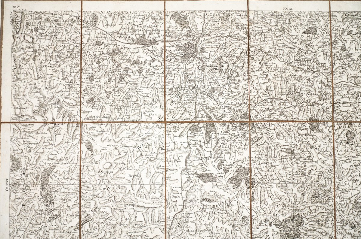
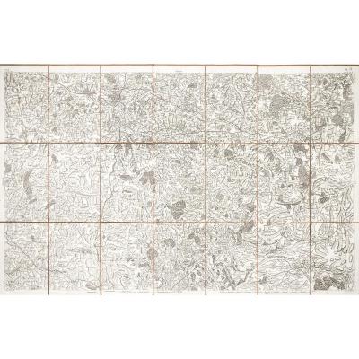
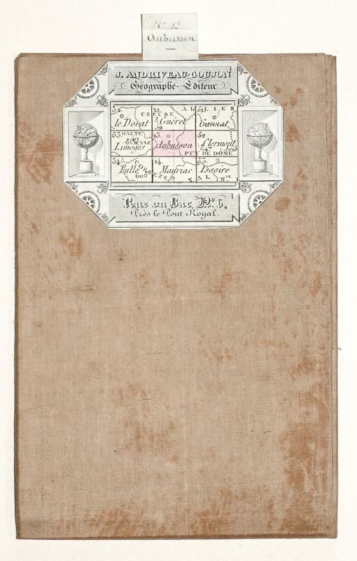
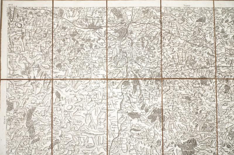
Old geographic map of Cassini de Thury - N ° 13 Aubusson -
Original antique map
Original map of Cassini produced in 1763, published by Andriveau - Goujon around 1815.
Stacked at the time and mounted in 21 sections.
Sheet format: 93 x 60 cm.
Folded format: 20 x 13.5 cm.
Very good state.
You can consult all the maps and engravings available in your region by clicking on the link of our website specializing in ancient geographic archives: https://cartes-livres-anciens.com/categorie-produit/cartes-geographiques-anciennes-original-antique-maps/france/auvergne-limousin/
Possibilities of secure payment by bank card on our website: https://cartes-livres-anciens.com/produit/cartes-geographiques-anciennes-original-antique-maps/france/auvergne-limousin/carte-ancienne-de-cassini-de-thury-aubusson/
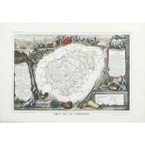
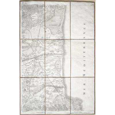
The map of Cassini, which it would be more correct to name the map of Cassini since it takes its name from a family of four Italian geographers installed in the kingdom at the end of 17th century, is the first large cartographic enterprise covering the whole of French territory. It consists of 180 sheets, the surveys of which began in 1756 and were completed in 1789. They were engraved on copper plates and then printed at the Paris Observatory from 1757 to 1790. Intended for sale to a rich audience, some editions have also been watercolored. Cassini's map owes its extraordinary precision to the method of triangulation, used for its development. This method consists in measuring the distance between two points B and C then, from a reference point A, in measuring the angles of the lines BA and CA. The geographer then only has to apply the trigonometry formulas in order to know the distances BA and CA. This method was used by the Dutchman Snellius in 1615, then by Father Picard in 1670 and, finally, from 1683 to 1718, for the measurement of a large meridian going from Dunkirk to Perpignan. The corners of each sheet of Cassini's map show the distances in toises to the meridian of Paris and its perpendicular (which joins Saint-Malo and Strasbourg). In addition to this main triangulation, each board has nearly 300 landmarks (buildings, heights), useful for establishing a secondary triangulation. In fact, the mentions on the card are many and varied. There are thus information relating to the relief (forests, marshes, rivers, ponds), communication routes (roads, canals, bridges), administrative and religious organization (the provincial limits, diocese, parishes) or civil and religious buildings (churches, abbeys, priories, mills, castles). Cassini's map is still used today by many researchers, amateurs or professionals, attached to the study of toponyms, archeology, historical geography or even the history of the environment. (Departmental Archives) The canvas maps Originally reserved for wall maps, the canvas, whose function is to consolidate the paper, is gradually used for other types of maps such as those drawn up and used in the 17th century by military engineers . […] This technique will experience a considerable development in the 18th century and in particular from 1740-1750, date on which the editors and merchants of geography systematically distribute maps "glued on canvas" or "mounted on canvas" or even "folding" " Because it can be folded in different ways, the card becomes more manageable and consultation easier. The merchant Julien offers the interlining of the cards "to be able to fold them in all directions, and to have in front of only the necessary part" or even "so as to use them on a desk without causing them least embarrassment ”. He finally indicates that "these cards, or cut sheets, still have the advantage, being pasted on canvas, of not spoiling". Desnos, on the other hand, sells the leaves of the Cassini Card "glued on canvas & folded for the pocket". In the 18th century, the interlining was made in the publisher's shop, sometimes even by him […]. In the 19th century, interlining became a specialty of certain publishers and merchants of cards. Goujon announces itself as a "Colleur et Marchand de Cartes Géographiques", rue de Savoie then quai des Augustins. The War Depot, a major producer of maps, did not always make the interlining and frequently entrusted it to Goujon and Vignon. In 1802-1803, the expenses of supplies and interfacing by the care of these publishers were such that the production of maps (drawing and engraving) was slowed down. It is true that the interlining sometimes considerably increases the price of the card […] all the more since the card, then folded, is very often offered in a case. (Media Library Apostrophe-Espace Patrimoine May-June 2014)
Original antique map
Original map of Cassini produced in 1763, published by Andriveau - Goujon around 1815.
Stacked at the time and mounted in 21 sections.
Sheet format: 93 x 60 cm.
Folded format: 20 x 13.5 cm.
Very good state.
You can consult all the maps and engravings available in your region by clicking on the link of our website specializing in ancient geographic archives: https://cartes-livres-anciens.com/categorie-produit/cartes-geographiques-anciennes-original-antique-maps/france/auvergne-limousin/
Possibilities of secure payment by bank card on our website: https://cartes-livres-anciens.com/produit/cartes-geographiques-anciennes-original-antique-maps/france/auvergne-limousin/carte-ancienne-de-cassini-de-thury-aubusson/
The map of Cassini, which it would be more correct to name the map of Cassini since it takes its name from a family of four Italian geographers installed in the kingdom at the end of 17th century, is the first large cartographic enterprise covering the whole of French territory. It consists of 180 sheets, the surveys of which began in 1756 and were completed in 1789. They were engraved on copper plates and then printed at the Paris Observatory from 1757 to 1790. Intended for sale to a rich audience, some editions have also been watercolored. Cassini's map owes its extraordinary precision to the method of triangulation, used for its development. This method consists in measuring the distance between two points B and C then, from a reference point A, in measuring the angles of the lines BA and CA. The geographer then only has to apply the trigonometry formulas in order to know the distances BA and CA. This method was used by the Dutchman Snellius in 1615, then by Father Picard in 1670 and, finally, from 1683 to 1718, for the measurement of a large meridian going from Dunkirk to Perpignan. The corners of each sheet of Cassini's map show the distances in toises to the meridian of Paris and its perpendicular (which joins Saint-Malo and Strasbourg). In addition to this main triangulation, each board has nearly 300 landmarks (buildings, heights), useful for establishing a secondary triangulation. In fact, the mentions on the card are many and varied. There are thus information relating to the relief (forests, marshes, rivers, ponds), communication routes (roads, canals, bridges), administrative and religious organization (the provincial limits, diocese, parishes) or civil and religious buildings (churches, abbeys, priories, mills, castles). Cassini's map is still used today by many researchers, amateurs or professionals, attached to the study of toponyms, archeology, historical geography or even the history of the environment. (Departmental Archives) The canvas maps Originally reserved for wall maps, the canvas, whose function is to consolidate the paper, is gradually used for other types of maps such as those drawn up and used in the 17th century by military engineers . […] This technique will experience a considerable development in the 18th century and in particular from 1740-1750, date on which the editors and merchants of geography systematically distribute maps "glued on canvas" or "mounted on canvas" or even "folding" " Because it can be folded in different ways, the card becomes more manageable and consultation easier. The merchant Julien offers the interlining of the cards "to be able to fold them in all directions, and to have in front of only the necessary part" or even "so as to use them on a desk without causing them least embarrassment ”. He finally indicates that "these cards, or cut sheets, still have the advantage, being pasted on canvas, of not spoiling". Desnos, on the other hand, sells the leaves of the Cassini Card "glued on canvas & folded for the pocket". In the 18th century, the interlining was made in the publisher's shop, sometimes even by him […]. In the 19th century, interlining became a specialty of certain publishers and merchants of cards. Goujon announces itself as a "Colleur et Marchand de Cartes Géographiques", rue de Savoie then quai des Augustins. The War Depot, a major producer of maps, did not always make the interlining and frequently entrusted it to Goujon and Vignon. In 1802-1803, the expenses of supplies and interfacing by the care of these publishers were such that the production of maps (drawing and engraving) was slowed down. It is true that the interlining sometimes considerably increases the price of the card […] all the more since the card, then folded, is very often offered in a case. (Media Library Apostrophe-Espace Patrimoine May-June 2014)
115 €
Period: 19th century
Style: Louis 16th, Directory
Condition: Excellent condition
Material: Paper
Reference (ID): 579620
Availability: In stock
Print