
Geographical Map Of The World Continents
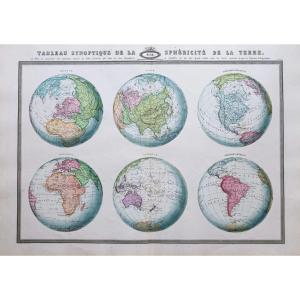
Tableau synoptique de la sphéricité de la Terre.
Grande épreuve originale réalisée en 1860. Garnier F.A cartographe.
Très belle impression en couleurs.
Infimes rousseurs.
Très bon état.
Format feuille : 87 x 61 cm.
Format gravure : 78,5 x 52,5 cm.
Original antique map of 1860.
Cette carte est le tableau synoptique de six aspects différents qu’auraient la Terre pour un observateur qui, pouvant l’embrasser d’un coup d’œil, quoiqu’à une distance infinie, lui ferait prendre à son gré la position la plus convenable pour étudier spécialement chacune des principales divisions adoptées par la géographie. Ce tableau remplacera avec avantage les sphères en usage dans les collèges.
Nouvelle géographie réalisée par le cartographe L.A Garnier en 1860, membre de la société de Géographie depuis 1850.
La parfaite netteté des coloris, le choix du papier et l’exécution typographique furent unanimement salués par la communauté scientifique de l’époque. Peu courant.
Vous pouvez consulter l’ensemble des cartes et gravures disponibles sur votre région en cliquant sur le lien de notre site internet spécialisé en archives anciennes géographiques :
https://cartes-livres-anciens.com/categorie-produit/cartes-geographiques-anciennes-original-antique-maps/monde-cartes-marines/mappemonde/
Règlement sécurisé par carte bancaire sur notre site internet en cliquant sur le lien :
https://cartes-livres-anciens.com/produit/cartes-geographiques-anciennes-original-antique-maps/monde-cartes-marines/mappemonde/carte-geographique-ancienne-des-continents/
Toutes nos cartes et gravures sont accompagnées d’un certificat d’authenticité.
Synoptic table of the sphericity of the Earth. Large original proof made in 1860. Garnier FA cartographer. Very nice color print. Minor foxing. Very good state. Sheet size: 87 x 61 cm. Engraving format: 78.5 x 52.5 cm. Original antique map of 1860. This map is the synoptic table of six different aspects that the Earth would have for an observer who, being able to embrace it at a glance, although at an infinite distance, would make him take in his according to the most suitable position for the special study of each of the principal divisions adopted by geography. This table will advantageously replace the spheres in use in colleges. New geography produced by the cartographer LA Garnier in 1860, member of the Geographical Society since 1850. The perfect sharpness of the colours, the choice of paper and the typographic execution were unanimously praised by the scientific community of the time. Uncommon. You can consult all the maps and engravings available in your region by clicking on the link of our website specializing in ancient geographical archives: https://cartes-livres-anciens.com/categorie-produit/cartes-geographiques-anciennes -original-antique-maps/monde-cartes-marines/mappemonde/ Secure payment by credit card on our website by clicking on the link: https://cartes-livres-anciens.com/produit/cartes-geographiques-anciennes- original-antique-maps/world-marine-maps/world-map/old-geographical-map-of-continents/ All our maps and engravings are accompanied by a certificate of authenticity.
650 €
Period: 19th century
Style: Other Style
Condition: Excellent condition
Material: Paper
Reference (ID): 1064890
Availability: In stock
Print